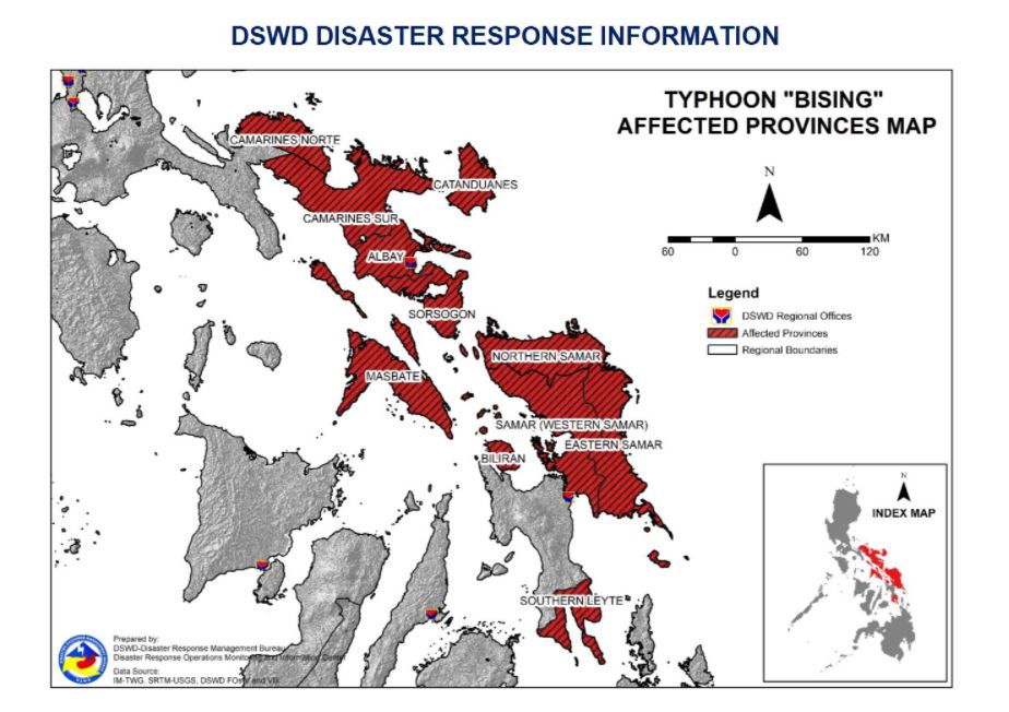
Philippines, Typhoon Surigae (Bising)
Description
Issued at 11:00 PM, 19 April 2021, TYPHOON "BISING" SLIGHTLY WEAKENS AS IT MOVES NORTHWARD OVER THE PHILIPPINE SEA.
• Hazards affecting land areas
• Heavy Rainfall:
• Tonight through tomorrow (20 April), moderate to heavy with at times intense rains will be experienced over Bicol Region and Northern Samar. Under these conditions and considering the antecedent rainfall over the aforementioned areas, flooding (including flashfloods) and rain-induced landslides are highly likely to occur especially in areas identified in hazard maps as highly or very highly susceptible to these hazards.
• PAGASA Regional Services Divisions may issue local thunderstorm/rainfall advisories and heavy rainfall warnings while the Hydrometeorology Division and River Basin Flood Forecasting and Warning Centers may issue General Flood Advisories and Basin Flood Bulletins as appropriate.
• Severe Winds:
• Tropical cyclone winds of at least strong breeze to near gale in strength extend outward up to 500 km from the center of the typhoon. Destructive typhoon-force winds extend outward up to 110 km from the center of the typhoon.
• In the next 24 hours, the northeasterly wind flow enhanced by the typhoon will also bring strong breeze to near gale conditions with higher gusts over the rest of Northern Luzon and the rest of Aurora and Quezon that are not under any Tropical Cyclone Wind Signal (TCWS). Such conditions are more likely to occur in the coastal and mountainous areas.
• Hazards affecting coastal waters
• In the next 24 hours, under the influence of Typhoon “BISING” and an enhanced northeasterly wind flow, the following sea conditions will be experienced over the coastal waters of the country:
• Very rough to high seas over the northern and eastern seaboards of Luzon (4.5 to 10.0 m), and rough to high seas over the northern and eastern seaboards of Eastern Visayas (3.0 to 7.0 m) Sea travel is risky for all types of seacrafts over these waters.
• Rough to very rough seas over the northern and western seaboards of Northern Luzon (2.8 to 4.5 m), and rough seas over the eastern seaboards of Caraga and Davao Oriental and the remaining seaboards of areas under TCWS (2.5 to 4.0 m) Sea travel is risky for small seacrafts over these waters. Mariners without the proper experience should immediately seek safe harbor.
• Moderate to rough seas over the western seaboard of Central Luzon (1.2 to 3.0 m). Mariners of small seacrafts are advised not to venture out over these waters. Inexperienced mariners of these vessels should avoid navigating in these conditions.
• Track and Intensity Outlook
• On the forecast track, Typhoon “BISING” will move generally northward or north northwestward until Wednesday evening (21 April) or Thursday (22 April) early morning. Afterwards, the typhoon will move northeastward from the landmass of Luzon throughout Thursday and east northeastward to eastward on Friday (23 April) and Saturday (24 April). The typhoon is projected to exit the Philippine Area of Responsibility on Sunday (25 April).
• The typhoon is forecast to maintain its current intensity in the next 12 to 24 hours before gradually weakening throughout the remainder of the forecast period.
At 10:00 PM today, the center of the eye of Typhoon "BISING" was located based on all available data at 500 km East of Infanta, Quezon (14.9 °N, 126.3 °E )
A total of 40,658 families or 158,112 persons were affected in 758 barangays in Regions V and VIII
There are 8,585 families or 34,560 persons currently taking temporary shelter in 456 evacuation centers in Region
There are 10,515 families or 40,522 persons temporarily staying with their relatives and/or friends in Region V
There are 520 damaged houses; of which, 52 are totally damaged and 468 are partially damaged
A total of ₱1,680.00 worth of assistance was provided by LGUs to the affected
Status of Prepositioned Resources: Stockpile and Standby Funds
The DSWD Central Office (CO), Field Offices (FOs), and National Resource Operations Center (NROC) have stockpiles and standby funds amounting to ₱1,599,209,936.49 with breakdown as follows (see Table 2):
a. Standby Funds
A total of ₱556,438,277.65 standby funds in the CO and FOs. Of the said amount, ₱517,992,176.43 is the available Quick Response Fund (QRF) in the CO.
b. Stockpiles
A total of 375,862 family food packs (FFPs) amounting to ₱191,218,897.77, other food items amounting to ₱328,782,370.91 and non-food items (FNIs) amounting to ₱522,770,390.16 are available.
Detail Event
- Maximum Sustained Wind Speed (km/h)
- 215
URL News
- No News Link
URL Videos
- No Video Link
Supported Files

Highest Impact
0
Dead
1
Missing
13
Injured
408.1K
Affected Person
58.4K
Displaced