Affected Area/s
- Magelang
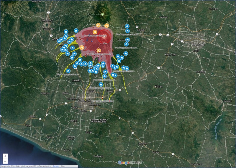
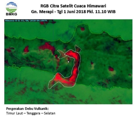
Update between 28 May - 3 June 2018 = 1. On 1 June 2018, Mount Merapi erupted three times at 0820 hrs, 2024 hrs and 2100hrs (UTC+7). The one in the morning released a column of ash cloud up to 6000 m with ash shower observed in Semarang city, Semarang Regency, Ungaran, Salatiga, Boyolali, Solo city, Karanganyar, Klaten, Demak, Kendal, Sleman and Magelang. Eruption on 2024 hrs released an ash column with the height of 2500 meters and followed by a 1000 meters ash column at 2100 hrs. 2. Ahmad Yani Ariport and Adi Sumarmo Airport were temporarily shut down on 1 June 2018. At least 25 flights have been canceled / delayed. 3. Mount Merapi Alert Status maintained at Level II with 3 km permanent danger zone. 4. 570 people were displaced and forced to evacuate at Tlogolele, reported by BNPB spokeperson. = Update between 21-27 May 2018 = Mount Merapi increased its volcanic activities and saw phreatic eruptions occurred on 21, 22 and 23 2018. 1. BNPB advised general public to stay away from community activities and maintain a 3 km safety distance radius from Mount Merapi. 2. Climbing activities are temporarily prohibited except for investigation and research activities related to disaster mitigation. 3. The volcanic ash rain fell around Mount Merapi as the area of Sleman Regency covers the Cangkringan District (Glagaharjo Village, Kepuharjo Village, Umbulharjo Village), Pakem Sub-district (Purwobinangun Village, Hargobinangun Village, Kaliurang Village), and Ngemplak Sub-District (Widomartani Village). In Klaten district, volcanic ash rain falls in Kemalang Sub-district (Balerante Village and Panggang Village). 4. About 298 residents from Kalitengah Lor, Kalitengah Kidul, and Srunen sub-districts in Cangkringan subdistrict of Sleman District evacuate independently to Glagaharjo Village Hall. 5. A total of 362 residents of Hamlet Takeran and Dukuh Stabelan in Tlogolele Village Boyolali District evacuate independently in the refuge Tologolele Village. The number of independent refugees continues to grow. BPBD has distributed the aid and is still carrying out data collection. 6. There were 4 records of phreatic eruption accompanied by a roar between Monday (21/5/2018) and Tuesday (22/05/2018) at 0330 hrs. UTC+7. The phreatic eruption was on 21/5/2018 at 0125 hrs. UTC+7 with a duration of 19 minutes reaching a height of 700m, at 0938 hrs. UTC+7 with a duration of 6 minutes reaching an eruption column height of 1200m, at 1750 hrs. UTC+7 with a duration of 3 minutes at an unexamined eruption column height, and on 22/5/2018 at 0147 hrs. UTC+7 with a duration of 3 minutes reaching a column height of 3,500m 7. PVMBG raised to ALERT Level II (WASPADA) for Mount Merapi after the unsteady eruption. 8. With the increasing activities of Merapi Volcano, BNPB and PVMBG released the “Check Position” tool as part of increasing preparedness of the general public. AHA Centre is monitoring closely the situation and will provide updates if additional information becomes available
Dead
Missing
Injured
Affected Person
Displaced