Philippines, Landslide in Naga City, Cebu
Sep 20, 2018 15:00
Sep 27, 2026 15:17
Location
Coordinate:
10.208899, 123.745359
Administrative:
Cebu, Philippines
Affected Area:
Cebu
Hazard
Main : Landslide- Inundated Area (km) = fill value here
- Maximum Flood Depth (cm) = fill value here
Description
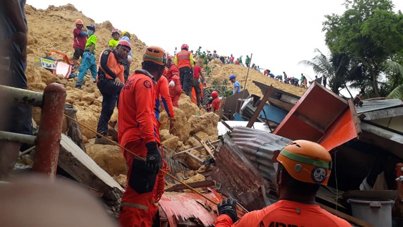
MANILA, Philippines – At least 897 families, or 2,836 individuals were affected bt the landslide in Naga City, Cebu that killed at least 29 and buried homes in two different barangays. The Department of Social Welfare and Development (DSWD) said in a statement on Saturday, September 22, that 5 evacuation centers are currently catering to the affected families, namely: Naga Central Elementary School Enan Chiong Activity Center (ECAC) Naalad Elementary School Apo Cement Gym Naga High School. ECAC has the highest number of evacuees, with around 500 families. Mayor Kristine Chiong said on Friday, September 21, that at least 57 households were directly affected by the landslide which was triggered by days of heavy monsoon rains. As of Friday, 9 people have been rescued, while 67 were still missing or unaccounted for. At least 11 bereaved families each received P25,000 burial assistance from the DSWD. "Makaka-asa po kayo nang patuloy na ayuda mula sa ahensiya hanggang sa kayo ay muling makabangon at makapag-simulang muli (You can expect continuous support from the DSWD until you can recover and start anew.)," DSWD Secretary Virgina Orogo said. The DSWD Field Office 7 continues to provide food and non-food items to the affected families. To date it has already extended relief support worth P2.02 million. Since Thursday‘ landslide, Chiong has already requested the Sangguniang Panglungsod (city council) to place the whole Naga City under a state of calamity. Environment Secretary Roy Cimatu has also suspended quarry operations in Central Visayas and 7 other regions pending their safety assessment.
Impact Statistic
77
Dead
57
Missing
7
Injured
8.7K
Affected Person
8.7K
Displaced
Human SADDD
- Dead 77
- Missing 57
- Injured 7
- Affected Person 8,655
- Affected Family 2,087
- Internaly Displaced People 8,655
- Refugees 0
- Evacuation Center (in Country) -
- Evacuation Center (out Of Country) 0
House
- Affected Houses 83
- Damage Partial 6
- Totally Damage 77
Infrastructure
- Bridges 0
- Number of Roads 0
- Road Distance (km) 0.00
Public
- Schools -
- Health -
- Government Office / Public Facilities 0
- Settlements 0
- Worship Places 0
- Others 0
General
Cost
- Local Currency 0.00
- Cost of Damages 0.00
- Cost of Damages (USD) -
- Cost of Assistance 80,476,000.00
- Cost of Assistance (USD) 1,453,921.00
Agricultural
- Rice Field 0.00
- Other Crops 0.00
- Fish Ponds 0
- Cattle 0
- Poultries 0
- Livestock 0
Relevant Disasters
The ASEAN Disaster Information Network (ADINet) is a repository of information concerning hazards and disasters that have happened in the region. The platform is open for public, which means that the public can submit information about any hazard and disaster to the AHA Centre. Thereafter, the AHA Centre will verify and validate any submitted information to ensure the accuracy of the data inputs. The AHA Centre can also add new information when relevant and as necessary. ADINet has been recording disaster information in the region since the AHA Centre was operational in 2012.

Supported by :