Philippines - Tropical Storm Sanba (Basyang)
Feb 12, 2018 01:09
Sep 27, 2026 15:11
Location
Coordinate:
9.95972, 124.127626
Administrative:
Bohol, Philippines
Affected Area:
Surigao del Sur, Agusan del Sur, Agusan del Norte, Dinagat Islands, Surigao del Norte
Hazard
Main : Tropical Cyclone- Maximum Sustained Wind Speed (km/h) = fill value here
Description
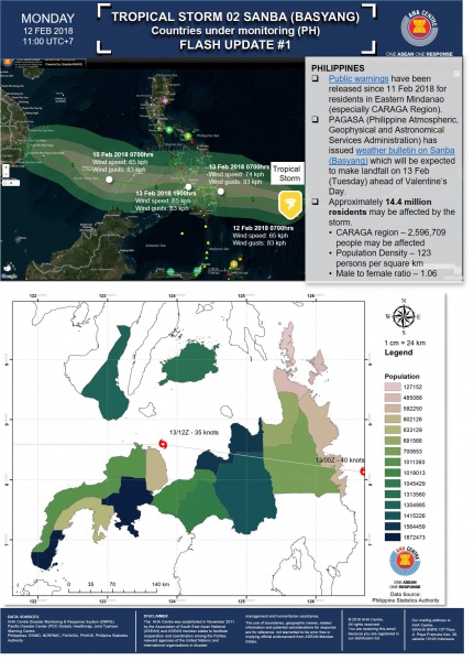
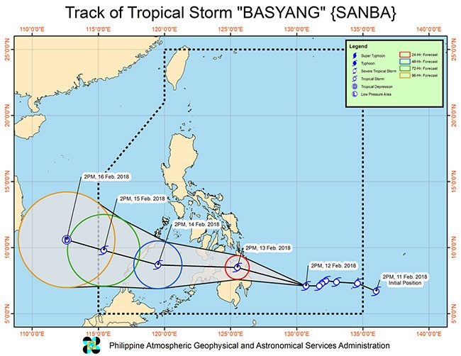
Update 18 Feb 2018 = Tropical Storm Sanba (Basyang) felt Philippines Areas of Responsibility on 16 Feb 2018. 1) A total of 57,192 families / 238,068 persons were affected in 517 barangays in Regions MIMAROPA, VI, VII, VIII and CARAGA. 2) A total of 844 families or 3771 persons are staying inside 19 evacuation centers in Regions MIMAROPA, VII and CARAGA. According to the affected population data, the most affected province was Bohol Province. 3) A total of 21 road sections and 7 bridges were affected in Regions VI, VII, VIII and CARAGA. 4) There was no indication that international assistance needed. = Update 13 Feb 2018 = Tropical depression Basyang is now traversing the Sulu Sea after making landfall in Dumaguete City, Negros Oriental, state weather bureau PAGASA said Wednesday. In its 5 a.m. advisory, PAGASA said Basyang, with international name Sanba, has maintained its west northwest direction and is forecast to make a possible landfall over Southern Palawan Wednesday night. Basyang had maximum sustained winds of 45 kilometers per hour near the center, with gusts of up to 60 kph. It is forecast to move west southwest at a speed of 26 kph. Tropical cyclone warning signal no. 1 remains hoisted over the following areas: Northern section of Zamboanga del Norte Palawan, including Calamian and Cuyo groups of islands Southern section of Negros Occidental Southern section of Negros Oriental Scattered to widespread moderate to heavy rains will prevail over Palawan and Western Visayas in the next 24 hours. The Visayas, Bicol, Zamboanga Peninsula, Northern Mindanao and Caraga will experience scattered light to moderate with at times heavy rains. As of 4 a.m., the eye of the tropical depression was located 185 kilometers west southwest of Dumaguete City, Negros Oriental. Basyang is expected to leave the Philippine area of responsibility on Friday. = Update 12 Feb 2018 = Issued at 5:00 PM today, "BASYANG" has slightly accelerated while moving closer towards eastern Mindanao. Scattered to widespread moderate to heavy rains will prevail in the next 24 hours over Visayas, Caraga, Northern Mindanao, Zamboanga Peninsula and the provinces of Davao del Norte, Davao del Sur, Davao Oriental, Compostela Valley, North Cotabato, Maguindanao and Lanao del Sur. Residents of these areas must continue monitoring for updates, take precautionary measures against possible flooding and landslides, and coordinate with their respective local disaster risk reduction and management offices. Expected to make landfall in Caraga Region tomorrow morning or afternoon (February 13). Sea travel remains risky over the seaboards of areas under Tropical Cyclone Warning Signal (TCWS), the seaboard of Northern Luzon, and the eastern seaboards of Central Luzon, Southern Luzon and Eastern Visayas due to the approaching Tropical Storm and the surge of the Northeast Monsoon. Possible raising of TCWS #1 over Aklan, Capiz, Antique, Zamboanga Sibugay and the rest of Zamboanga del Norte and of Zamboanga del Sur in the next bulletin.
Impact Statistic
0
Dead
0
Missing
0
Injured
255.5K
Affected Person
146.4K
Displaced
Human SADDD
- Dead -
- Missing -
- Injured -
- Affected Person 255,470
- Affected Family 61,273
- Internaly Displaced People 146,407
- Refugees 0
- Evacuation Center (in Country) 19
- Evacuation Center (out Of Country) 0
House
- Affected Houses 2,102
- Damage Partial 1,666
- Totally Damage 436
Infrastructure
- Bridges 8
- Number of Roads 22
- Road Distance (km) 0.00
Public
- Schools -
- Health -
- Government Office / Public Facilities 0
- Settlements 0
- Worship Places 0
- Others 0
General
Cost
- Local Currency 0.00
- Cost of Damages 167,955,031.00
- Cost of Damages (USD) 3,046,000.00
- Cost of Assistance 16,338,000.00
- Cost of Assistance (USD) 296,000.00
Agricultural
- Rice Field 0.00
- Other Crops 0.00
- Fish Ponds 0
- Cattle 0
- Poultries 0
- Livestock 0
Relevant Disasters
The ASEAN Disaster Information Network (ADINet) is a repository of information concerning hazards and disasters that have happened in the region. The platform is open for public, which means that the public can submit information about any hazard and disaster to the AHA Centre. Thereafter, the AHA Centre will verify and validate any submitted information to ensure the accuracy of the data inputs. The AHA Centre can also add new information when relevant and as necessary. ADINet has been recording disaster information in the region since the AHA Centre was operational in 2012.

Supported by :