Philippines - Tropical Depression Agaton
Jan 01, 2018 20:47
Sep 27, 2026 15:11
Location
Coordinate:
7.689804, 125.2364
Administrative:
Bukidnon, Philippines
Affected Area:
Surigao del Sur, Agusan del Sur, Agusan del Norte, Bohol, Cebu, Dinagat Islands, Siquijor, Surigao del Norte
Hazard
Main : Tropical Cyclone- Maximum Sustained Wind Speed (km/h) = fill value here
Description
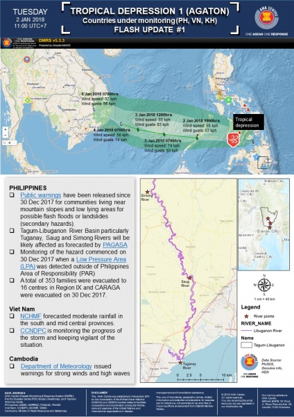
Update as of 12 January 2018 = 1) Department of Social Welfare and Development reported 18,513 families or 83,772 persons are affected in 267 barangays in Regions MIMAROPA, VI, VII, VIII, X, and CARAGA. 2) A total of 303 families or 1,198 persons are currently staying inside 10 evacuation centers in Regions VI, VII, and X. 3) A total of 86 families or 280 persons are currently staying with relatives in Region VI. 4) A total of 138 damaged houses; of which, 36 are totally damaged, while 102 are partially damaged. 5) A total of ₱2,027,352.50 have been provided to the Affected Families; of which, ₱1,165,195.50 came from the DSWD, ₱836,957.00 came from LGUs, and ₱25,200.00 came from NGOs. = Update as of 7 January 2018 = On 01 January 2018, the Low Pressure Area (LPA) east southeast of Surigao City has developed into a Tropical Depression and was named "Agaton". Which heavily affected the Regions of MIMAROPA, Region VI, Region VII, Region VIII and CARAGA. National Disaster Risk Reduction and Management Council (NDRRMC) and Department of Social Welfare and Development (DSWD) reported: 1) 18513 families or 83772 persons are affected in 267 barangays in Regions MIMAROPA, VI, VII, VIII, X and CARAGA. 2) 3,076 families or 13,338 persons are currently staying inside 56 evacuation centers in Regions MIMAROPA, V, VII, X, and CARAGA. 3) A total of 324 families or 1,424 persons are currently staying with relatives in Regions MIMAROPA, VI, VII, and CARAGA. 4) A total of ₱859,510.00 have been provided to the Affected Families—of which, ₱1,027,789.50 came from the DSWD while ₱139,083.00 came from the affected local government units. 5) A total of 3 persons were confirmed dead, 9 injured and 2 missing. = Initial Report = "AGATON" IS NOW TRAVERSING SULU SEA AND HEADING TOWARD PALAWAN. Scattered to widespread moderate to heavy rains is expected over the areas with TCWS#1 as well as the Bicol Region, Eastern Visayas, Panay Island, Romblon, and Mindoro provinces. Residents of these areas must undertake precautionary measures against possible flooding and landslides and coordinate with their respective local disaster risk reduction and management offices. Sea travel is risky over the areas under TCWS #1 and the seaboards of Northern Luzon and Southern Luzon, eastern seaboard of Central Luzon, eastern and western seaboards of Visayas, and eastern seaboard of Mindanao due to the surge of the Northeast Monsoon and TD "AGATON".
Impact Statistic
3
Dead
2
Missing
9
Injured
83.9K
Affected Person
47.1K
Displaced
Human SADDD
- Dead 3
- Missing 2
- Injured 9
- Affected Person 83,908
- Affected Family 18,547
- Internaly Displaced People 47,089
- Refugees 0
- Evacuation Center (in Country) 56
- Evacuation Center (out Of Country) 0
House
- Affected Houses 162
- Damage Partial 123
- Totally Damage 39
Infrastructure
- Bridges 0
- Number of Roads 13
- Road Distance (km) 0.00
Public
- Schools -
- Health -
- Government Office / Public Facilities 0
- Settlements 0
- Worship Places 0
- Others 0
General
Cost
- Local Currency 0.00
- Cost of Damages 635,000,000.00
- Cost of Damages (USD) 11,515,000.00
- Cost of Assistance 2,027,352.00
- Cost of Assistance (USD) 34,828.00
Agricultural
- Rice Field 0.00
- Other Crops 0.00
- Fish Ponds 0
- Cattle 0
- Poultries 0
- Livestock 0
Relevant Disasters
The ASEAN Disaster Information Network (ADINet) is a repository of information concerning hazards and disasters that have happened in the region. The platform is open for public, which means that the public can submit information about any hazard and disaster to the AHA Centre. Thereafter, the AHA Centre will verify and validate any submitted information to ensure the accuracy of the data inputs. The AHA Centre can also add new information when relevant and as necessary. ADINet has been recording disaster information in the region since the AHA Centre was operational in 2012.

Supported by :