Myanmar, Landslide in Mandalay Region
Aug 24, 2021 19:26
Sep 27, 2026 15:18
Location
Coordinate:
21.209223306269, 96.003494301574
Administrative:
Mandalay, Myanmar
Affected Area:
Mandalay
Hazard
Main : Landslide- Inundated Area (km) = fill value here
- Maximum Flood Depth (cm) = fill value here
Description
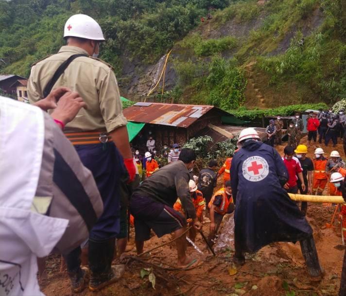
A landslide struck in the Mandalay Region of Myanmar on 24 August 2021 burying 4 homes in Mogok Township.
Fourteen people were buried under the collapsed houses. Teams of search and rescue workers including personnel from Myanmar Red Cross and the Fire Department searched through the wreckage of the buildings over the last few days. As of 26 August, officials said 11 bodies had been found. Three people survived but were injured.
Local observers said the landslide was caused by recent heavy rainfall. Around 2 weeks earlier heavy rain also took its toll on the township after a landslide caused the wall of a building to collapse, killing 3 people on 12 August. More than 145 mm of rain fell in just a few hours early on 12 August.
Fourteen people were buried under the collapsed houses. Teams of search and rescue workers including personnel from Myanmar Red Cross and the Fire Department searched through the wreckage of the buildings over the last few days. As of 26 August, officials said 11 bodies had been found. Three people survived but were injured.
Local observers said the landslide was caused by recent heavy rainfall. Around 2 weeks earlier heavy rain also took its toll on the township after a landslide caused the wall of a building to collapse, killing 3 people on 12 August. More than 145 mm of rain fell in just a few hours early on 12 August.
Impact Statistic
11
Dead
0
Missing
3
Injured
11
Affected Person
0
Displaced
Human SADDD
- Dead 11
- Missing -
- Injured 3
- Affected Person 11
- Affected Family 4
- Internaly Displaced People -
- Refugees -
- Evacuation Center (in Country) -
- Evacuation Center (out Of Country) -
House
- Affected Houses 4
- Damage Partial -
- Totally Damage 4
Infrastructure
- Bridges -
- Number of Roads -
- Road Distance (km) -
Public
- Schools -
- Health -
- Government Office / Public Facilities -
- Settlements -
- Worship Places -
- Others -
General
Cost
- Local Currency 0.00
- Cost of Damages -
- Cost of Damages (USD) -
- Cost of Assistance -
- Cost of Assistance (USD) -
Agricultural
- Rice Field -
- Other Crops -
- Fish Ponds -
- Cattle -
- Poultries -
- Livestock -
Relevant Disasters
The ASEAN Disaster Information Network (ADINet) is a repository of information concerning hazards and disasters that have happened in the region. The platform is open for public, which means that the public can submit information about any hazard and disaster to the AHA Centre. Thereafter, the AHA Centre will verify and validate any submitted information to ensure the accuracy of the data inputs. The AHA Centre can also add new information when relevant and as necessary. ADINet has been recording disaster information in the region since the AHA Centre was operational in 2012.

Supported by :