Affected Area/s
- Bali
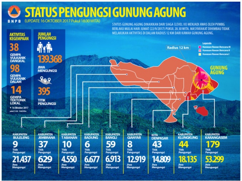
After escalating situation from 25 November, please refer to following link for Mt. Agung: http://adinet.ahacentre.org/reports/view/1016 UPDATE on 26, 27 and 29 October 2017 1) BNPB has estimated that the economic loss due to Mount Agung Warning status may reach IDR 2 trillion (approximately USD 147 million), particularly in financial and tourism sectors. 2) Governor of Bali, with the approval of BNPB, extended the emergency response status for Mount Agung for 14 days; i.e. effective for 27 October to 9 November 2017. 3) The PVMBG-ESDM has revised the status of Mount Agung from Warning (Level IV or awas) to Watch (Level III or waspada). Original post on 16 October 2017 Indonesia is on alert with the potential Mount Agung eruption after the volcano start to picking up its volcanic tremors from 16 September 2017, as recorded by the MAGMA.vsi of Indonesian Center for Volcano and Geological Disaster Mitigation, Ministry of Energy and Mineral Resources (PVMBG-ESDM). The PVMBG-ESDM raised the volcano activity notice of Mount Agung to Warning status (Level IV) on 22 September 2017. Subsequently, the emergency status declared by Bali Province local disaster management agency (BPBD) on 24 September 2017. Although there was no sign of immediate eruption and ash-cloud is not not visible, the number of affected persons continue arises. National Disaster Management Authority (BNPB) recorded 139,368 evacuees in 395 evacuation sites across 9 (nine) affected municipalities of Karangasem, Klungkung, Denpasar, Gianyar, Bangli, Badung, Tabanan, Jembrana and Buleleng. In order to ensure preparedness, the BNPB also has installed additional 6 sirens and 54 evacuation signs.
Dead
Missing
Injured
Affected Person
Displaced