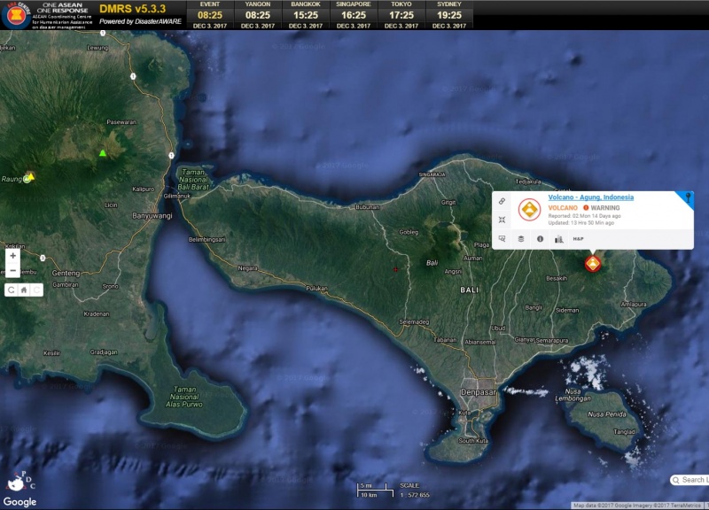
Affected Area/s
- Bali
- Nusa Tenggara Barat
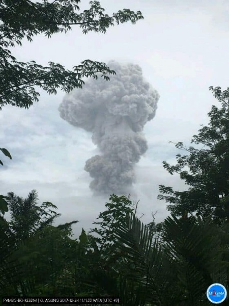
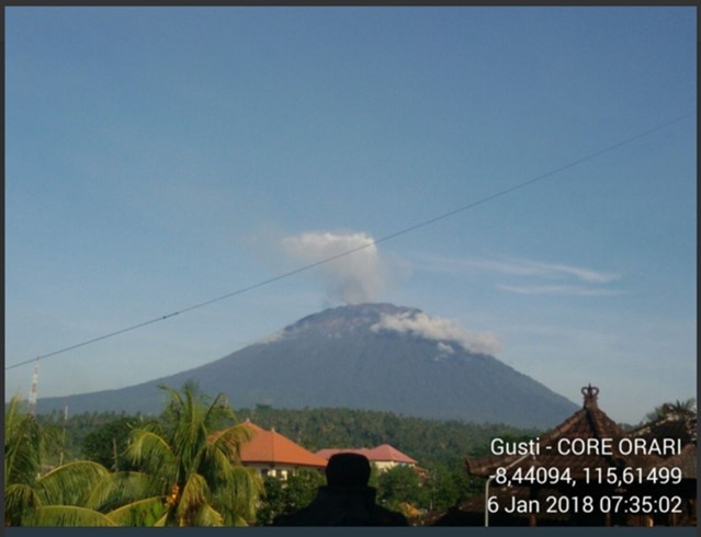
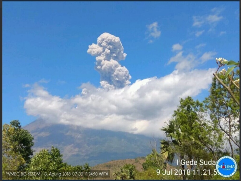
Update 9 July 2018 = National Disaster Management Authority (BNPB) reported eruption of Mount Agung on 9 July 2018. The eruption lasted for 2 minutes and 42 seconds and released a 2000 meters volcanich ash column. There is no revision to Mount Agung Alert Level III. In total, there was 4415 IDPs in 54 evacuation centers. Ngurah rai International Airport remains in normal operation. = Update 2 July 2018 = The eruption of G. Agung, Bali occurred on 02 July 2018 at 21:04 WITA with the ash column height observed  ± 2,000 m above the peak ( ± 5.142 m above sea level). The gray columns were observed in gray with a thick intensity leaning towards the west. This eruption is recorded in the seismogram with a maximum amplitude of 24 mm and the duration of  ± 7 minutes 21 seconds. The eruption occurs strombolian with a banging sound. Flares of incandescent lava observed out the crater reaches a distance of 2 km. The number of refugees at this time: 1. Banjar, kreteg, mantri: 50 families / 200 people 2. Budakeling: 2 families / 10 people fled at relatives house 3. Br wates middle east widower: 20 families / 80 people 4. Ds Macang: 3 families / 11 people 5. Refugees in Banjar Batusesa, Kel. Menanga: Male: 35 Female : 46 Total: 81 6. Ds Setia Budi 25 families / 110 people 7. Klungkung BPBD Office 3 families / 10 people. Total number of IDPs overall 138 families / 492 people. Status of Mount Agung is currently Level III (Watch). = Update on 29 June 18 G. Agung (Bali): Based on the analysis of visual and instrumental data and considering the potential danger threat, on 10 February 2018 at 09.00 WITA the status of G. Agung is lowered from Level IV to Level III (Siaga). From yesterday until this morning, visually volcano clear until covered with fog. Observed emissions of gas and ash continuous grayish white with medium to thick intensity. The smoke column height is about 1500 - 2500 m from the top of the peak. The wind was blowing weakly westward. The seismograph record of June 28, 2018 was recorded: 27 times a blowout earthquake Continuous tremor with maximum amplitude 5-10 mm (dominant 5 mm) The date of June 29, 2018 (00:00 am to 06:00 pm) recorded: Continuous tremor with maximum amplitude of 2-15 mm (dominant 10 mm) Recommendation: Communities around G. Agung and climbers / visitors / tourists not to be on, do not climb any activity in the Danger Estimate Zone ie in all areas within a 4 km radius of Kawah Puncak G. Agung. Estimated Zone Dangers are dynamic and continuously evaluated and can be changed at any time following the most recent / recent G. Agung observation data. Residents who live and move around the river streams that head on Mount Agung to be aware of the potential threat of secondary danger of rain lava flows that can occur especially in the rainy season and if eruption material is still exposed in the peak area. The area of the lava flowing lava flow follows the rivers flowing upstream at Gunung Agung. Level III status (Standby) is only valid within a 4 km radius as mentioned above, outside of the area activity can run normally and still remain safe, but must keep vigilance. VONA: VONA sent ORANGE color codes, issued on June 28, 2018 at 15:01 WITA, related to continuous gas emission with thin ash since 10:30 WITA with maximum ash column height about 5142 m above sea level or about 2000 m from top of the peak. The wind is blowing west and southwest. = Update on 30 April 2018 = G. Agung, Bali.VONA sent ORANGE color code, published April 30, 2018 at 23:17 GMT, related to eruption with ash column height about 4642 m above sea level or about 1500 m above peak, wind blowing southwest. = Update on 13 February 2018 = Mount Agung erupted again on 13 February 2018, 11.49 UTC+8 with volcanic ash column measured at 15000 meter. The PVMBG and BNPB maintained Alert Level 3 (WATCH) for Mount Agung, with mandatory exclusion zone maintained at 4 km radius. BNPB spokeperson stated 15,445 IDPs are still taking refuge at 146 evacuation sites. = Update on 10 February 2018 = National Disaster Management Authority (BNPB) reported the decision of Geological Agency, Ministry of Energy and Mineral Resources, on the latest alert status of Mount Agung, Bali. Effective from 09.00 UTC+8 Mount Agung alert status has been reduced to Watch (Siaga, Level III out IV). The mandatory exclusion zone has been reduced to 4 km radius from the tip of Mount Agung. = Update on 15 January 2018 = National Disaster Management Authority (BNPB) reported the following updates on Mount Agung: 1) Mount Agung erupted on 15 January 2018, 07:23 UTC+8 with volcanic ash measured around 2000-2500 meters. 2) Mandatory exclusion zone is maintained at 6 kkm from the tip of Mount Agung 3) Volcano Observatory Notice for Aviation maintained at Orange level 4) Number of IDPs recorded at 47268 evacuated in 229 evacuation centers. = Update on 12 January 2018 = 1) Mount Agung erupted on 11 January 2018, 18.00 UTC+8 releasing volcanic ash column at up to 2500 meters. 2) Exclusion zone maintained at 6 km radius. 3) 53207 remains evacuated at 233 evacuation centers. = Update on 6 January 2018 = 1) PVMBG has reduced the mandatory exclusion zone for Mt. Agung to 6 km radius from its peak. 2) BNPB reported number of IDPs stands at 70449 persons at 238 evacuation centers. 3) PVMBG maintains Mt. Agung IV alert level, the highest (AWAS). 4) BNPB ensure that the other areas in Bali beyond the mandatory exclusion zone are safe for tourism activities. 5) Mt. Agung released ash rain on 2 January and smoke on a daily basis until 6 January 2018. = Update on 24 December 2017 = 1) Mt. Agung erupted again on 23 December 2017, 11.57 (UTC +8) and releasing 2,500 meters of volcanic ash. 2) Volcanic ash were downpour in the exclusion zone of 8-10 km. The exclusion zone is still within the radius of 8 km, with 10 km expansion zone to north-northeast and southeast-southwest direction. 3) President of Indonesian and high level officials visited Bali on 22 December 2017 and emphasize that Bali is safe for tourism and government prioritizes response only for municipalities within the prone areas. 4) BNPB reported number of IDPs at 71,129 in 240 evacuation center; with the following details: 1. Buleleng regency, 9,938 IDPs in 9 evacuation sites; 2. Klungkung regency, 11,441 IDPs in 43 evacuation sites; 3. Karangasem regency, 42,998 IDPs in 132 evacuation sites; 4. Bangli regency, 977 IDPs in 4 evacuation sites; 5. Tabanan regency, 730 IDPs in 10 evacuation sites; 6. Denpasar city, 748 IDPs in 5 evacuation sites; 7. Gianyar regency, 3,502 IDPs in 8 evacuation sites; 8. Badung regency, 590 IDPs in 5 evacuation sites; 9. Jembrana regency, 205 IDPs in 23 evacuation sites. = Update on 10 December 2017 = Based on Gunung Agung Update provided by Indonesian National Disaster Management Authority (BNPB), the total number of internally displaced people (IDPs) are 70,079 distributed in 237 evacuation sites; with the following details: 1. Buleleng regency, 10,774 IDPs in 9 evacuation sites; 2. Klungkung regency, 10,950 IDPs in 43 evacuation sites; 3. Karangasem regency, 41,597 IDPs in 131 evacuation sites; 4. Bangli regency, 961 IDPs in 4 evacuation sites; 5. Tabanan regency, 676 IDPs in 8 evacuation sites; 6. Denpasar city, 734 IDPs in 5 evacuation sites; 7. Badung regency, 487 IDPs in 5 evacuation sites; 8. Jembrana regency, 367 IDPs in 24 evacuation sites. For more details update on Gunung Agung from the BNPB, please find the following link: https://sites.google.com/view/updategunungagung = Updates on 29 Nov 2017 = Regent of Karangasem declared the Official Emergency Response Status effective for 27 November until 10 December 2017, through Karangasem Regent Decision Number 698/HK/2017. Status of Volcano Notice for Aviation (VONA) has been revised to Orange. Official figures place 5,189 tourists being stranded in Bali due to closure of the airports. = Update on 28 Nov 2017 = Mt. Agung is currently in its magmatic phase with constant thick column of ash reaching a height of 2,000-3,400 meters from the volcanic peak. As per official figures, there are total of 23,377 individuals housed in 234 shelters across the 9 districts on Bali.
Dead
Missing
Injured
Affected Person
Displaced