Cambodia, Floods in 4 provinces
Jul 19, 2018 14:09
Sep 27, 2026 15:17
Location
Coordinate:
11.476436, 103.08748
Administrative:
Kaôh Kong, Cambodia
Affected Area:
Kâmpóng Spœ, Kaôh Kong, Batdâmbâng
Hazard
Main : Flood- Inundated Area (km) = fill value here
- Maximum Flood Depth (cm) = fill value here
Description
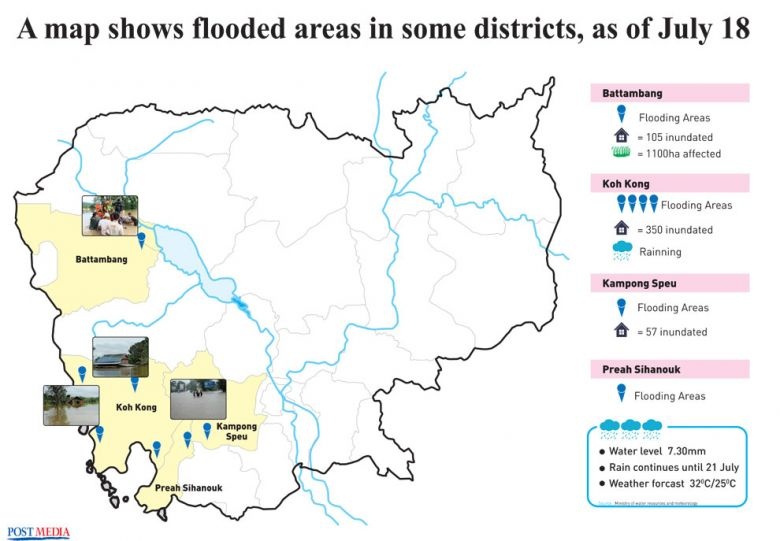
The National Committee for Disaster Management (NCDM) sent a report to Prime Minister Hun Sen on Thursday, saying that 1,786 houses and thousands of hectares of crops have been flooded. The NCDM said local authorities and armed forces have been cooperating with the Cambodian Red Cross to get people in affected areas to higher ground. Additionally, National Election Committee deputy secretary general Som Sorida said many polling stations for the upcoming election have been flooded with this week’s heavy rains. “We have two options – if the polling stations are flooded, we can delay the voting there, but if safe places are available, we can change the polling stations,” he said. ------------------- The Kampong Speu provincial Committee for Disaster Management on Wednesday issued an alert after non-stop heavy rain caused widespread flooding. In Koh Kong province, authorities are working with the disaster committee and the Cambodian Red Cross to assist those affected after more than 350 homes were inundated. In Battambang, the provincial department of agriculture said that, as of Wednesday, 1,100 hectares of paddy fields in Ek Phnom district were seriously affected by flooding. The Kampong Speu administration called on people to be extra cautious in order to avoid accidents, and asked local authorities at all levels to pay close attention to the vulnerable and children and to carefully monitor water levels in their areas. The alert said Wednesday’s non-stop rainfall caused water levels to reach 7.3 metres at the province’s Peam Kley pumping station, a level dangerously close to causing the Prek Tnaot river to break its banks and flood a number of nearby areas. “[A flood here] would impact agricultural land, people’s livelihoods, houses and property, and could affect their health through the spread of diseases,” the announcement states. However, Ministry of Water Resources and Meteorology spokesman Chan Vutha, said people in the nearby Phnom Sruoch district “should not be overly worried regarding the rainfall” because plans were in place to open canal gates to release water and make room for further rain. --------------------------------- Flooding in Cambodia has damaged over 1,700 homes in several provinces, according to the country’s National Committee for Disaster Management (NCDM). Flooding began on 17 July, 2018 after a period of heavy rain, affecting the provinces of Kampong Speu, Battambang, Koh Kong and Phreah Sihanouk. As many as 1,786 houses and 1,100 hectares of paddy fields have been damaged. The NCDM said local authorities and armed forces have been cooperating with the Cambodian Red Cross to get people in affected areas to higher ground. Over the last few days flooding has also affected parts Kampot province, and Pur Senchey district in Phnom Penh. Phnom Penh Governor HE Khuong Sreng visited affected areas on 20 July, 2018. The Ministry of Health’s Communicable Disease Control Department (CDC) has alerted the affected population of possible dangers in time of floods. A backup plan for polling stations possibly affected by floods is being developed by the country’s National Election Committee (NEC). Influenced by Tropical Storm Son-Tinh which made landfall in northern Vietnam on 18 July, more severe weather including heavy rainfall has been forecast in Cambodia for the next few days.
Impact Statistic
0
Dead
0
Missing
0
Injured
8.9K
Affected Person
0
Displaced
Human SADDD
- Dead -
- Missing -
- Injured -
- Affected Person 8,930
- Affected Family 1,786
- Internaly Displaced People -
- Refugees 0
- Evacuation Center (in Country) -
- Evacuation Center (out Of Country) 0
House
- Affected Houses 1,786
- Damage Partial 1,786
- Totally Damage 1,786
Infrastructure
- Bridges 0
- Number of Roads 0
- Road Distance (km) 0.00
Public
- Schools -
- Health -
- Government Office / Public Facilities 0
- Settlements 0
- Worship Places 0
- Others 0
General
Cost
- Local Currency 0.00
- Cost of Damages 0.00
- Cost of Damages (USD) -
- Cost of Assistance 0.00
- Cost of Assistance (USD) -
Agricultural
- Rice Field 1,100.00
- Other Crops 0.00
- Fish Ponds 0
- Cattle 0
- Poultries 0
- Livestock 0
Relevant Disasters
The ASEAN Disaster Information Network (ADINet) is a repository of information concerning hazards and disasters that have happened in the region. The platform is open for public, which means that the public can submit information about any hazard and disaster to the AHA Centre. Thereafter, the AHA Centre will verify and validate any submitted information to ensure the accuracy of the data inputs. The AHA Centre can also add new information when relevant and as necessary. ADINet has been recording disaster information in the region since the AHA Centre was operational in 2012.

Supported by :