Thailand, Effect of TS Bebinca, Flood in Nan Province
Aug 25, 2018 11:26
Sep 27, 2026 15:17
Location
Coordinate:
18.754459, 100.624804
Administrative:
Nan, Thailand
Affected Area:
Nan
Hazard
Main : Flood- Inundated Area (km) = fill value here
- Maximum Flood Depth (cm) = fill value here
Description
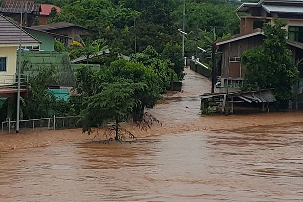
As forecast by Thailand Meteorological Department suggests, Tropical Storm Bebinca may bring heavy rainfall and caused flooding in northern part of Viet Nam, Lao PDR, and Thailand. In Thailand, floods were reported in Nan Province. On 18 August 2018, The Nan River and its tributaries burst their banks, flooding more than 1,000 households in seven districts. The water levels at the Nan River kept rising and was measured at 8.30 metres at Kadlaeng water. The storm caused heavy downpours over the upper North which caused the main Nan river to burst its banks and flood large parts of seven districts: Chiang Klang, Pua, Tha Wang Pha, Mae Charim, Santisuk, Phu Phiang, and Muang. Effect of the flood 1) In seven districts affected above, a total of 1000 families have been displaced. 2) In Phu Phiang district, the highest flood level reported around one metre. 3) 300 families in Tambon Du Tai, Muang district, had their homes submerged. 4) In Mae Hong Son, more than 100 rai of farmland inundated 5) In Lampang, 30 houses in tambon Wang Kiew, Wang Nua District were submerged with water level around 2 metres. 6) In Chiang Mai, 100 villages in San Kamphaeng and Doi Saket districts were alerted with possible flooding. 7) Highway between Chiang Mai and Chiang Rai, in Doi Saket district, was impassable. Response taken 1) Thai Meteorological Department had released warning on TS Benbica since 13 August 2018. 2) Residents and local emergency teams erected embankments of sandbags in low-lying area. 3) Local disaster prevention and mitigation offices are responding by using flat-bottomed boats to rescue people and delivered relief items.
Impact Statistic
0
Dead
0
Missing
0
Injured
44K
Affected Person
44K
Displaced

Human SADDD
- Dead -
- Missing -
- Injured -
- Affected Person 44,000
- Affected Family 1,000
- Internaly Displaced People 44,000
- Refugees 0
- Evacuation Center (in Country) -
- Evacuation Center (out Of Country) 0
House
- Affected Houses 1,000
- Damage Partial 0
- Totally Damage 330
Infrastructure
- Bridges 0
- Number of Roads 0
- Road Distance (km) 0.00
Public
- Schools -
- Health -
- Government Office / Public Facilities 0
- Settlements 0
- Worship Places 0
- Others 0
General
Cost
- Local Currency 0.00
- Cost of Damages 0.00
- Cost of Damages (USD) -
- Cost of Assistance 0.00
- Cost of Assistance (USD) -
Agricultural
- Rice Field 100.00
- Other Crops 0.00
- Fish Ponds 0
- Cattle 0
- Poultries 0
- Livestock 0
Relevant Disasters
The ASEAN Disaster Information Network (ADINet) is a repository of information concerning hazards and disasters that have happened in the region. The platform is open for public, which means that the public can submit information about any hazard and disaster to the AHA Centre. Thereafter, the AHA Centre will verify and validate any submitted information to ensure the accuracy of the data inputs. The AHA Centre can also add new information when relevant and as necessary. ADINet has been recording disaster information in the region since the AHA Centre was operational in 2012.

Supported by :