Lao PDR, Floods due to TS Bebinca
Aug 21, 2018 09:08
Sep 27, 2026 15:17
Location
Coordinate:
20.238643, 101.75366
Administrative:
Oudômxai, Lao PDR
Affected Area:
Oudômxai, Louangphrabang
Hazard
Main : Flood- Inundated Area (km) = fill value here
- Maximum Flood Depth (cm) = fill value here
Description
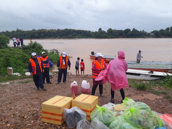
Department of Meteorology and Hydrology of Lao PDR had forecast heavy rainfall in the north-eastern and north-western are of the country since the beginning of Week 34. It was followed by alarming flood alert in Ban Mixal Monitoring station. Once it made landfall in Viet Nam, and approaching Lao PDR, TS Bebinca unleashed torrential rain in many parts of the country, affecting agriculture, houses, and other infrastructure; i.e. including in areas previously affected by floods due to TS Son-Tinh in July 2018. Farmland in 411 villages has been affected, more than 34,000 hectares of crops have been flooded, 25,900 hectares of farmland have been affected, and 60 irrigation systems and some dwellings have been damaged. The districts of Xaybouly, Vilabouly, Atsaphangthong, Atsaphon, Champhon, Xonbouly are the worst affected. In Xaybouly district, 7,000 hectares of farmland have been damaged, along with roads, and power is out in some areas so local communities cannot use electricity. Officials are continuing to survey the damage while helping affected communities and calculating the cost of the damage. Oudomxay has also reported flooding as Tropical Storm Bebinca moves across the country. Heavy rainfall lasting several hours on Thursday inundated a market. Water up to one metre deep flooded the market, but has now receded. Officials are surveying other districts and expediting damage assessments. TS Bebinca also damaged dwellings, roads, farmland and cattle in Phoukhoun district, Luang Prabang province, on Thursday. Huaphan province is another area at high risk of damage from Bebinca, so authorities are warning villagers living along rivers to be alert for flooding after the water has risen to dangerous levels. Many villages in Xamtay district have already been flooded and officials are calculating the cost of the damage. Tropical Storm Bebinca is moving across northern Vietnam and Laos from August 16-18. People should prepare for severe conditions, warned the Department of Meteorology and Hydrology. Provinces in at-risk are as are on the alert and have been monitoring water levels in the main rivers in preparation for storm activity. The flood also caused emergency operations in Attapeu Province on hold due to rising water level at Xekong River.
Impact Statistic
0
Dead
0
Missing
0
Injured
30.8K
Affected Person
0
Displaced
Human SADDD
- Dead -
- Missing -
- Injured -
- Affected Person 30,762
- Affected Family 6,900
- Internaly Displaced People -
- Refugees 0
- Evacuation Center (in Country) -
- Evacuation Center (out Of Country) 0
House
- Affected Houses 0
- Damage Partial 0
- Totally Damage -
Infrastructure
- Bridges 0
- Number of Roads 0
- Road Distance (km) 0.00
Public
- Schools -
- Health -
- Government Office / Public Facilities 0
- Settlements 0
- Worship Places 0
- Others 60
General
Cost
- Local Currency 0.00
- Cost of Damages 0.00
- Cost of Damages (USD) -
- Cost of Assistance 0.00
- Cost of Assistance (USD) -
Agricultural
- Rice Field 34,000.00
- Other Crops 25,900.00
- Fish Ponds 0
- Cattle 0
- Poultries 0
- Livestock 0
Relevant Disasters
The ASEAN Disaster Information Network (ADINet) is a repository of information concerning hazards and disasters that have happened in the region. The platform is open for public, which means that the public can submit information about any hazard and disaster to the AHA Centre. Thereafter, the AHA Centre will verify and validate any submitted information to ensure the accuracy of the data inputs. The AHA Centre can also add new information when relevant and as necessary. ADINet has been recording disaster information in the region since the AHA Centre was operational in 2012.

Supported by :