Affected Area/s
- Subang
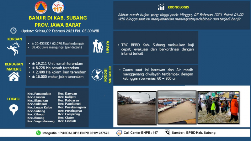
As of 13 Feb 2021. Due to high intensity rain since 7 Feb 2021 at 01.00 AM WIB, triggered 21 sub district submerged. Those sub districts are Blanakan, Sukasari, Legon Kulon, Subang, Cibog, Dawuan, Cipeundeuy, Cipunagara, Pabuaran, Patokbeusi, Tambakdahan, Pusakanagara, Pusakajaya, Compreng, Pagaden, Binong, Sagalaherang, Ciater, Cisalak). The water level is bout 10 – 150 cm Update: Tuesday, February 9, 2021 Pkl. 07.00 WIB Chronology: Due to high rainfall on Sunday, February 7, 2021 at 01.00 WIB until now it has caused air discharge and floods and landslides Location: Kec. Pamanukan Kec. Ciasem Kec. Blanakan Kec. Sukasari Kec. Legonkulon Kec. Subang Kec. Cibogo Kec. Dawuan Kec. Kalijati Kec. Pabuaran Kec. Patokbeusi Kec. Pusakanagara Kec. Pusakajaya Kec. Compreng Kec. Binong Kec. Sagalaherang Kec. Ciater Kec. Cisalak Kec. Cipunagara Kec. Tambakdahan Kec. Pagaden Fatalities: • ± 20,453 households / 62,070 people affected • 38,453 People displaced (data collection) Material Loss: • ± 19,211 Housing units submerged • ± 11,246 Ha of submerged rice fields • ± 2,768 Ha of submerged fish ponds • ± 16,000 meters of roads are submerged • 10 units of worship facilities were submerged • 6 school units submerged • 7 housing units (RB) • 1 housing unit (RS) • 2 bridge units (RB) • ± 12 points of landslides (small scale) Effort: • TRC BPBD Kab. Subang conducts rapid assessments, evacuations and coordinates with related agencies Advanced Condition: • The weather is cloudy • Water still stagnates the affected area with a TMA 60 - 300 cm Source: • Pusdalops BPBD Kab. Subang Informed by: PUSDALOPS BNPB Complaint / Call Center Number: 117 (Toll Free) Instagram: pusdalops_bnpb Twitter: @Bnpbpusdalops
Dead
Missing
Injured
Affected Person
Displaced