Affected Area/s
- Sumenep
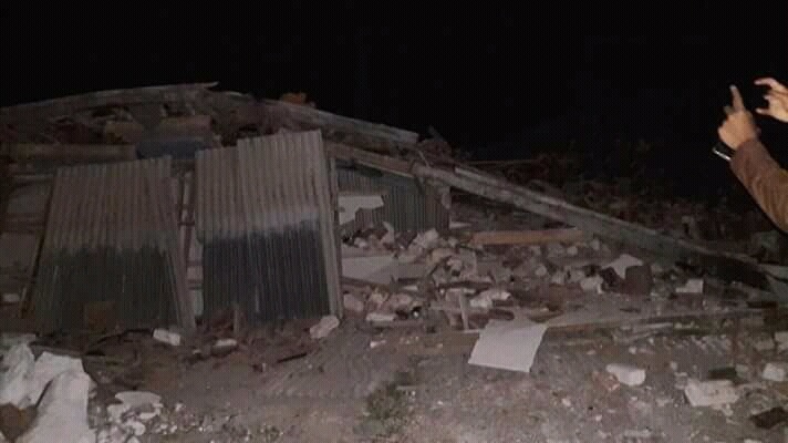
Before Lebaran, people in Sumenep Regency of East Java Province were shocked by the earthquake with a strength of 4.8 SR on 13/6/2018 at 20:06 pm. BMKG reported an earthquake epicenter on land at a distance of about 6 km northeast of Sumenep, East Java with a depth of 12 kilometers. The earthquake is not a potential tsunami. This earthquake is a type of intraplate earthquake with a shallow hypocenter due to local fault activity. The quake was felt strong for 5 seconds. People scattered panic outside the house and buildings. At the same time there is also a tarawih prayer. Earthquake shocks are felt up and down accompanied by damaged buildings. These hard shocks are felt by the people in Batu Putih sub-district covering Bulaan Village, Batu Putih Laok Village, Bantelan Village, Sergeng Village, and Dasuk District in East Dasuk Village. Temporary data 6 people were slightly injured, 25 houses were severely damaged, 52 units were lightly damaged, 2 mosques were severely damaged, 1 mosque was lightly damaged, 1 unit of madrasah was severely damaged and 1 unit of ponpes was lightly damaged. Losses estimated hundreds of millions of dollars. BPBD Kabupaten Sumenep together with apparatus from Kodim 0827 Sumenep, Polri, Basarnas, PMI, volunteers and SKPD still do data collection and emergency handling. Data collection of the amount of material losses due to the earthquake is still done. Officers with the community cleaned up the wreckage of the collapsed buildings. Assistance is channeled to communities affected by the earthquake. Meanwhile, elsewhere, a series of earthquakes shook the Mentawai Islands region on 13/6/2018 until 14/6/2018. BMKG reported aftershock activity 12 times in Mentawai Islands after earthquake with power of 5.8 SR on 13/6/2018 at 06.08 WIB. The earthquake epicenter lies at coordinates of 2.0 LS and 98.76 BT, or precisely located at sea at a distance of 90 km west of Kota Tua Pejat, Mentawai Islands District, West Sumatra Province at a depth of 13 km. This earthquake was included in the classification of shallow earthquakes caused by the activity of the Indo-Australian Plate subducting under the Eurasian Plate megathrust precisely in the zone which is a plate subduction zones are located in the Indian Ocean west of Sumatra. The earthquake was felt weak by the people in Mantawai. Even some aftershocks do not feel the shock. No casualties and damage caused by the earthquake in Mentawai. Community activities are running normally. BPBD Kabupaten Mentawai Islands continue to conduct monitoring and socialization to the community. Sutopo Purwo Nugroho Head of Information Data and Public Relations Center of BNPB
Dead
Missing
Injured
Affected Person
Displaced