Viet Nam, High tides and floods in 5 southern provinces
May 03, 2017 05:02
Sep 27, 2026 15:11
Location
Coordinate:
9.190564, 105.703554
Administrative:
Bạc Liêu, Viet Nam
Affected Area:
Bạc Liêu, Bình Dương, Cà Mau
Hazard
Main : Flood- Inundated Area (km) = fill value here
- Maximum Flood Depth (cm) = fill value here
Description
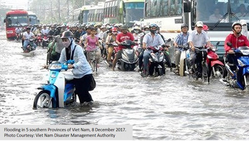
Central Steering Committee for Natural Disaster Prevention and Control (CCNDPC) and Viet Nam Disaster Management Authority (VDMA) reported flooding in four provinces of Binh Duong, Ca Mau, Vinh Long, Ben Tre and Bac Lieu on 8 December 2017. The flooding have affected 1,138 families in those provinces. It also inundated hundreds of houses, i.e. 200 houses in Binh Duong, 50 houses in Ben Tre and 319 houses in Ca Mau. It also damaged several key infrastructures, including at total of 2.046 m wide embankment was washed, drifted, damaged, including: Ben Tre 20m, Vinh Long 254m, Ca Mau 1,772m (most of this dike is covered with fish pond cover). In Vinh Long province 02 temporary dams were broken (Vinh Tan and Tam Binh Districts), total length of 11m; Loss of aquaculture: 280.4 ha (Ca Mau province), a flooded market center. Estimated damage is about 1.598 million Standing office of the Steering Committee for CIP and TKCN of Tay Ninh province said that heavy rain on 06/12, in the communes of Loc Hung, An Tinh (Trang Bang district), Tra Vong (Tan Bien district) have caused 637.3 hectares of flooded agricultural area. Estimated initial damage value of 6.122 million (VND).
Impact Statistic
0
Dead
0
Missing
0
Injured
5.7K
Affected Person
0
Displaced
Human SADDD
- Dead -
- Missing -
- Injured -
- Affected Person 5,690
- Affected Family 1,138
- Internaly Displaced People -
- Refugees 0
- Evacuation Center (in Country) -
- Evacuation Center (out Of Country) 0
House
- Affected Houses 569
- Damage Partial 0
- Totally Damage 569
Infrastructure
- Bridges 0
- Number of Roads 0
- Road Distance (km) 0.00
Public
- Schools -
- Health -
- Government Office / Public Facilities 0
- Settlements 0
- Worship Places 0
- Others 0
General
Cost
- Local Currency 0.00
- Cost of Damages 7,720,000.00
- Cost of Damages (USD) 310.00
- Cost of Assistance 0.00
- Cost of Assistance (USD) -
Agricultural
- Rice Field 0.00
- Other Crops 6,373.00
- Fish Ponds 0
- Cattle 0
- Poultries 0
- Livestock 0
Relevant Disasters
The ASEAN Disaster Information Network (ADINet) is a repository of information concerning hazards and disasters that have happened in the region. The platform is open for public, which means that the public can submit information about any hazard and disaster to the AHA Centre. Thereafter, the AHA Centre will verify and validate any submitted information to ensure the accuracy of the data inputs. The AHA Centre can also add new information when relevant and as necessary. ADINet has been recording disaster information in the region since the AHA Centre was operational in 2012.

Supported by :