Viet Nam, Flooding, Landslide, Wind and Storm in Southern Central and Southern Provinces (TC Cempaka)
Jul 24, 2021 08:05
Sep 27, 2026 15:18
Location
Coordinate:
20.503892260549, 104.62207026663
Administrative:
Thanh Hóa, Viet Nam
Affected Area:
Thanh Hóa
Hazard
Main : Tropical Cyclone- Maximum Sustained Wind Speed (km/h) = fill value here
Description
On the morning of July 26, the Standing Office of the Central Steering Committee for Natural Disaster Prevention and Control held a briefing on natural disaster prevention and control. At the briefing, Mr. Khoa said that according to a quick report from the VPTT, the Steering Committee for Disaster Prevention and Control, the provinces of Binh Thuan, Gia Lai, Ca Mau, Hau Giang, Vinh Long and Can Tho city were affected by rain accompanied by thunderstorms. Damages are as follows: About people: 02 people died due to house collapse (in Vinh Long and Ca Mau); Returning home: 137 houses collapsed, roofs removed (Binh Thuan: 07 houses; Gia Lai: 01 houses; Hau Giang: 08 houses; Ca Mau: 12 houses; Vinh Long: 75 houses; Can Tho: 34 houses); Landslide: 30m river bank in Ngoc Hien district, Ca Mau province.
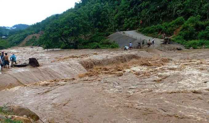
On the morning of July 24, Vice Chairman of the People's Committee of Muong Lat district (Thanh Hoa province) Hoang Van Dung said that in the past two days in the district, there was heavy rain due to the influence of the weakening tropical depression from Typhoon Cempaka. Assessing the complicated flood situation, the district government evacuated 305 households with about 1,400 people to a safe place.
Accordingly, the communes of Muong Lat that had to be evacuated included: Muong Ly, Trung Ly, Pu Nhi, Muong Chanh and Tam Chung.
Flooding caused some damage in Muong Lat. On the afternoon of July 23, floods poured into Sim stream, passing through Quang Chieu commune, swept away the temporary bridge from Pung village to three hamlets, Suoi Tut and Con Dao villages, making it difficult for nearly 180 households to travel. The government has sent people to guard, not allowing people and vehicles to pass.
Impact Statistic
2
Dead
0
Missing
0
Injured
2.2K
Affected Person
1.4K
Displaced
Human SADDD
- Dead 2
- Missing -
- Injured -
- Affected Person 2,210
- Affected Family 442
- Internaly Displaced People 1,400
- Refugees -
- Evacuation Center (in Country) -
- Evacuation Center (out Of Country) -
House
- Affected Houses 137
- Damage Partial 137
- Totally Damage -
Infrastructure
- Bridges -
- Number of Roads -
- Road Distance (km) -
Public
- Schools -
- Health -
- Government Office / Public Facilities -
- Settlements -
- Worship Places -
- Others -
General
Cost
- Local Currency 0.00
- Cost of Damages -
- Cost of Damages (USD) -
- Cost of Assistance -
- Cost of Assistance (USD) -
Agricultural
- Rice Field -
- Other Crops -
- Fish Ponds -
- Cattle -
- Poultries -
- Livestock -
Relevant Disasters
The ASEAN Disaster Information Network (ADINet) is a repository of information concerning hazards and disasters that have happened in the region. The platform is open for public, which means that the public can submit information about any hazard and disaster to the AHA Centre. Thereafter, the AHA Centre will verify and validate any submitted information to ensure the accuracy of the data inputs. The AHA Centre can also add new information when relevant and as necessary. ADINet has been recording disaster information in the region since the AHA Centre was operational in 2012.

Supported by :