Philippines, M7.2 Earthquake (corrected to M6.8) in Davao Occidental, Region XI
Nov 17, 2023 16:14
Dec 08, 2023 08:00
Location
Coordinate:
5.4172660914449, 125.42237833438
Administrative:
Davao del Sur, Philippines
Affected Area:
Davao del Sur, Sarangani, South Cotabato
Hazard
Main : Earthquake- Latitude = -
- Longitude = -
- Magnitude = 6.8
- Mechanism = Strike Slip
- Depth (km) = 63
- Magnitude Type = Richter Scale (ML)
- Intensity Scale = PHIVOLCS Earthquake Intensity Scale (PEIS)
- Maximum Intensity = 7
Description
As of 01 Dec 08OO HRS PST, NDRRMC reported:
-11 casualties, 37 injured persons
- 19,146 affected families (92,396 persons) in 2 regions, 4 provinces, 21 cities/municipalities, and 122 barangays
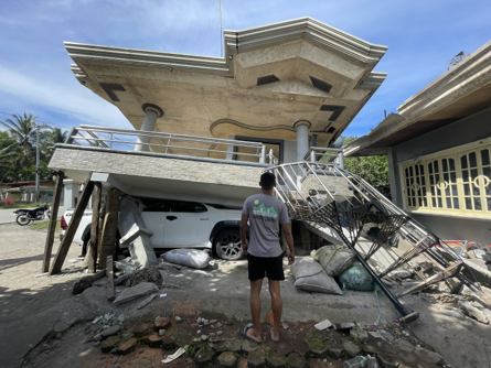
- 6,629 damaged houses (678 totally, 5,951 partially)
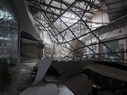
- 507 damaged infrastructure (estimated cost PHP 945,338,311 or USD 17,050,632), most of which are schools and government facilities
- 20 road sections and 5 bridge sections (8% not passable to all types of vehicles)
- 147 affected farmers and fisherfolks
- Power interruption in 21 municipalities (100% restored)
- 18 cities/municipalities with class suspension and 5 cities/municipalities with work suspension
- 2 municipalities declared under State of Calamity
- 1 related incident of earthquake-induced landslide reported in Region XI
- Cost of assistance: PHP 73,607,693 or USD 1,327,628
Based on NDRRMC's latest report (28 Nov 0800H PST)d, there have been
- 9 casualties, 37 injured persons
- 16,577 affected families (79,563 persons) in 2 regions, 4 provinces, 21 cities/municipalities, and 120 barangays
- 5,387 damaged houses (673 totally, 4,714 partially)
- 398 damaged infrastructure, most of which are schools and government facilities
- PHP 274,578,457 estimated cost of damaged infrastructure and other assets (USD 4,960,633)
- 20 road sections and 5 bridge sections (8% not passable to light vehicles)
- 147 affected farmers and fisherfolks
- Power interruption in 21 municipalities (100% restored)
- 18 cities/municipalities with class suspension and 5 cities/municipalities with work suspension
- 1 related incident of earthquake-induced landslide reported in Region XI
- PHP 84,382,532 cost of assistance provided (USD 1,524,485)
Based on NDRRMC's latest report (21 Nov 0400H PST)d, there have been
- 9 casualties, 16 injured persons
- 3,696 affected families (16,293 persons) in 2 regions, 3 provinces, 17 cities/municipalities, and 51 barangays
- 1,544 damaged houses (157 totally, 1,387 partially)
- 202 damaged infrastructure, most of which are schools and government facilities
- 16 road sections and 5 bridge sections (5% not passable to light vehicles)
- 50 affected farmers and fisherfolks
- Power interruption in 21 municipalities (100% restored)
- 25 cities/municipalities with class suspension and 5 cities/municipalities with work suspension
- 1 related incident of earthquake-induced landslide reported in Region XI
As of 20 Nov 0400H UTC+8, NDRRMC recorded
- 9 casualties, 15 injured persons
- 2,489 affected families (12, 885 persons) in 2 regions, 4 provinces, 18 cities/municipalities, and 43 barangays
- 826 damaged houses (97 totally, 729 partially)
- 118 damaged infrastructure
- 16 road sections and 5 bridge sections (5% not passable to light vehicles)
- 50 affected farmers and fisherfolks
- Power interruption in 21 municipalities (100% restored)
- 14 cities/municipalities with class suspension and 5 cities/municipalities with work suspension
- 1 related incident of earthquake-induced landslide reported in Region XI
As of 19 Nov
- At 0400H UTC+8, NDRRMC recorded 5 casualties and 6 injured persons; and a total of 71 damaged infrastructures
- 13 roads (2 of which are not passable) and 2 bridges were damaged (NDRRMC)
- Around 450 people were given medical care due to hyperventilation and panic (NDRRMC)
- Power interruption in 21 municipalities (NDRRMC)
As of 18 Nov DSWD DROMIC Report:
- 951 families or 1229 persons are affected, 70 houses (22 are totally damaged)
An earthquake with a magnitude of 7.2 (corrected to M6.8) at a depth of 10 km (corrected to 63 km) and epicenter at 05.37N, 125.15 E has occurred on 17 November 2023 at 0314 HRS UTC+7, 81 km west (corrected to 28 km southwest) of Sarangani (Davao Occidental), as reported by the Phivolcs.
As of 8:00 AM PST on 18 November 2023, the PHIVOLCS has recorded a total of 58 aftershocks ranging from M1.4 to M3.9. Aftershocks may persist for several days to weeks and some may be felt in nearby provinces.
Impacts as of 18 Nov:
- Power outage in General Santos City and Lebak, Sultan Kudarat;
- One damaged school and damaged houses in Sarangani, Davao Occidental.
- One dead person in Barangay Butuan, Jose Abad Santos, Davao Occidental is still being validated.
- About 200 people have been internally displaced
Impact Statistic
11
Dead
0
Missing
37
Injured
99.5K
Affected Person
194
Displaced
Human SADDD
- Dead 11
- Missing -
- Injured 37
- Affected Person 99,541
- Affected Family 20,575
- Internaly Displaced People -
- Refugees -
- Evacuation Center (in Country) -
- Evacuation Center (out Of Country) -
House
- Affected Houses 6,585
- Damage Partial 5,983
- Totally Damage 602
Infrastructure
- Bridges 5
- Number of Roads 20
- Road Distance (km) -
Public
- Schools -
- Health -
- Government Office / Public Facilities 535
- Settlements -
- Worship Places -
- Others -
General
Cost
- Local Currency -
- Cost of Damages 1,625,492,129.00
- Cost of Damages (USD) 29,139,303.00
- Cost of Assistance 86,117,296.00
- Cost of Assistance (USD) 1,543,780.00
Agricultural
- Rice Field -
- Other Crops -
- Fish Ponds -
- Cattle -
- Poultries -
- Livestock -
Relevant Disasters
The ASEAN Disaster Information Network (ADINet) is a repository of information concerning hazards and disasters that have happened in the region. The platform is open for public, which means that the public can submit information about any hazard and disaster to the AHA Centre. Thereafter, the AHA Centre will verify and validate any submitted information to ensure the accuracy of the data inputs. The AHA Centre can also add new information when relevant and as necessary. ADINet has been recording disaster information in the region since the AHA Centre was operational in 2012.

Supported by :