Philippines, M 6.4 earthquake in Manay, Davao Oriental
Sep 08, 2018 15:16
Sep 27, 2026 15:17
Location
Coordinate:
7.233401, 126.445741
Administrative:
Davao Oriental, Philippines
Affected Area:
Davao Oriental
Hazard
Main : Earthquake- Latitude = fill value here
- Longitude = fill value here
- Magnitude = fill value here
- Mechanism = fill value here
- Depth (km) = fill value here
- Magnitude Type = fill value here
- Intensity Scale = fill value here
- Maximum Intensity = fill value here
Description
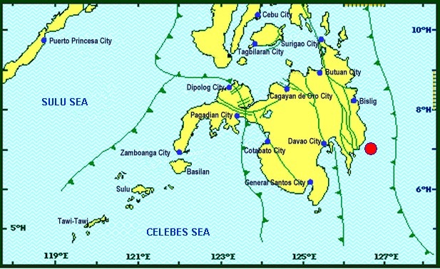
On 8 September 2018, 1516 hrs local time, a magnitude 6.4 earthquake occurred in Manay, Davao Oriental as reported by PHIVOLCS, NDRRMC, and DSWD. The epicenter was located at 7.13 N and 126.53 E at a depth of 10 km below ground surface. Municipalities in Davao Oriental and Davao City were exposed to intensity IV-V MMI. A total of 3.6 million of people were affected as they are located within the radius of 100 km from the earthquake epicentre. There were no casualties reported as of 9 September 2018, although NDRRMC reported that people are taking refuge with friends and relatives in the area. 6 houses were reported damages in Davao Oriental, City of Mati, and Tarragona. The regional Evacuation Center was also partially damaged. NDRRMC and RDRRMC are monitoring the situation and conducting assessment. The DSWD Central Office (CO), Field Offices (FOs), and National Resource Operations Center (NROC) have stockpiles and standby funds amounting to ₱1,111,374,714.11. A total of 337,502 Family Food Packs (FFPs) (see Table 4) amounting to ₱117,917,481.30 and available Food and Non-food Items (FNIs) amounting to ₱629,754,634.45. A total of ₱275,830,574.86 standby funds in the CO and FOs. Of the said amount, ₱227,950,586.00 is the available Quick Response Fund in the CO.
Impact Statistic
0
Dead
0
Missing
0
Injured
3.7M
Affected Person
0
Displaced
Human SADDD
- Dead -
- Missing -
- Injured -
- Affected Person 3,660,000
- Affected Family 732,000
- Internaly Displaced People -
- Refugees 0
- Evacuation Center (in Country) -
- Evacuation Center (out Of Country) 0
House
- Affected Houses 6
- Damage Partial 6
- Totally Damage 6
Infrastructure
- Bridges 0
- Number of Roads 0
- Road Distance (km) 0.00
Public
- Schools -
- Health -
- Government Office / Public Facilities 0
- Settlements 0
- Worship Places 0
- Others 0
General
Cost
- Local Currency 0.00
- Cost of Damages 0.00
- Cost of Damages (USD) -
- Cost of Assistance 0.00
- Cost of Assistance (USD) -
Agricultural
- Rice Field 0.00
- Other Crops 0.00
- Fish Ponds 0
- Cattle 0
- Poultries 0
- Livestock 0
Relevant Disasters
The ASEAN Disaster Information Network (ADINet) is a repository of information concerning hazards and disasters that have happened in the region. The platform is open for public, which means that the public can submit information about any hazard and disaster to the AHA Centre. Thereafter, the AHA Centre will verify and validate any submitted information to ensure the accuracy of the data inputs. The AHA Centre can also add new information when relevant and as necessary. ADINet has been recording disaster information in the region since the AHA Centre was operational in 2012.

Supported by :