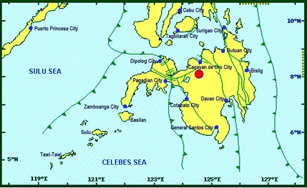
Philippines, M 5.0 Earthquake in Talakag, Bukidnon
Mar 12, 2018 01:48
Sep 27, 2026 15:17
Location
Coordinate:
7.647365, 124.74286
Administrative:
Lanao del Sur, Philippines
Affected Area:
Hazard
Main : Earthquake- Latitude = fill value here
- Longitude = fill value here
- Magnitude = fill value here
- Mechanism = fill value here
- Depth (km) = fill value here
- Magnitude Type = fill value here
- Intensity Scale = fill value here
- Maximum Intensity = fill value here
Description
A magnitude 5.0 earthquake has occurred in Talakag, Bukidnon, Philippines on 15 March 2018, 15.19 (UTC+8). In Bukidnon, earthquake intensity was reported between IV, V and VI. National Disaster Risk Reduction and Management Council (NDRRMC) reported minor damages in three barangays of Talakag, Bukidnon. In total 21 houses were damaged forcing 147 people (22 families) to be evacuated with their relatives and friends. There were also some damages to public facilities as follows: 1) In Barangay Indulang, Barangay Hall, a church and five schools; 2) In Barangay Tikalaan, one high school. OCD Region X office is closely monitoring the situation. MDRRMC of Talakag conducted rapid Damage Assessment and Needs Analysis (RDANA).
Impact Statistic
0
Dead
0
Missing
0
Injured
147
Affected Person
147
Displaced
Human SADDD
- Dead -
- Missing -
- Injured -
- Affected Person 147
- Affected Family 22
- Internaly Displaced People 147
- Refugees 0
- Evacuation Center (in Country) -
- Evacuation Center (out Of Country) 0
House
- Affected Houses 21
- Damage Partial 21
- Totally Damage 21
Infrastructure
- Bridges 0
- Number of Roads 0
- Road Distance (km) 0.00
Public
- Schools 6
- Health -
- Government Office / Public Facilities 0
- Settlements 0
- Worship Places 0
- Others 0
General
Cost
- Local Currency 0.00
- Cost of Damages 0.00
- Cost of Damages (USD) -
- Cost of Assistance 0.00
- Cost of Assistance (USD) -
Agricultural
- Rice Field 0.00
- Other Crops 0.00
- Fish Ponds 0
- Cattle 0
- Poultries 0
- Livestock 0
Relevant Disasters
The ASEAN Disaster Information Network (ADINet) is a repository of information concerning hazards and disasters that have happened in the region. The platform is open for public, which means that the public can submit information about any hazard and disaster to the AHA Centre. Thereafter, the AHA Centre will verify and validate any submitted information to ensure the accuracy of the data inputs. The AHA Centre can also add new information when relevant and as necessary. ADINet has been recording disaster information in the region since the AHA Centre was operational in 2012.

Supported by :