Philippines, Flooding, Landslide, Storm, and Wind in Region 6, 7, 8, Calabarzon and Mimaropa (TC LIONROCK)
Oct 04, 2021 11:34
Sep 27, 2026 15:19
Location
Coordinate:
11.368213294101, 122.63604206275
Administrative:
Capiz, Philippines
Affected Area:
Antique, Cebu, Capiz, Southern Leyte, Guimaras, Iloilo, Negros Occidental, Palawan
Hazard
Main : Tropical Cyclone- Maximum Sustained Wind Speed (km/h) = fill value here
Description
TC INVEST 92 W (local name: LANNIE)
04 October 2021
At 4:00 AM, the Low Pressure Area East of Surigao Del Norte developed into a Tropical Depression and was named “LANNIE”. It has maximum sustained winds of 45 km/h near the center, gustiness of up to 55 km/h, and central pressure of 1002 hPa. TCWS No. 1 was raised over The southern portion of Masbate (Pio V. Corpuz, Cataingan, Palanas, Dimasalang, Uson, Mobo, Milagros, Mandaon, Esperanza, Placer, Cawayan, Balud), the southern portion of Romblon (Cajidiocan, San Fernando, Magdiwang, Santa Maria, Odiongan, Alcantara, Ferrol, Looc, Santa Fe, San Jose), the southern portion of Oriental Mindoro (Roxas, Mansalay, Bulalacao, Bongabong), the southern portion of Occidental Mindoro (Sablayan, Calintaan, Rizal, San Jose, Magsaysay), and the northern portion of Palawan (El Nido, Taytay, Dumaran, Araceli) including Calamian and Cuyo Islands, Eastern Samar, Samar, Biliran, Leyte, Southern Leyte, Capiz, Aklan, Antique, Iloilo, Guimaras, Negros Occidental, the northern and central portions of Negros Oriental (Bais City, Mabinay, City of Bayawan, Basay, City of Tanjay, Manjuyod, Bindoy, Ayungon, Tayasan, Jimalalud, La Libertad, City of Guihulngan, Vallehermoso, Canlaon City), Cebu, and Bohol, Surigao del Norte, Dinagat Islands, the northern portion of Agusan del Norte (Magallanes, Remedios T. Romualdez, City of Cabadbaran, Tubay, Santiago, Jabonga, Kitcharao, Butuan City), the northern portion of Agusan del Sur (Sibagat, City of Bayugan, Prosperidad), and the northern portion of Surigao del Sur (San Miguel, Marihatag, San Agustin, Cagwait, Bayabas, Tago, City of Tandag, Cortes, Lanuza, Carmen, Madrid, Cantilan, Carrascal, Lianga) Tropical Depression (TD) "LANNIE" made landfall over Bucas Grande Island, Socorro, Surigao del Norte at 4:30 AM, over Cagdianao, Dinagat Islands at 5:00 AM, over Liloan, Southern Leyte at 7:30 AM, and over Padre Burgos, Southern Leyte at 8:00 AM.
At 11:00 AM, TD "LANNIE" was monitored over Canigao Channel and heading towards Camotes Sea. TCWS No. 1 was still raised in some areas in Luzon, Visayas and Mindanao. TD LANNIE made another series of landfalls in Mahanay Island, Talibon, Bohol at 12:30 PM, over Banacon Island, Jetafe, Bohol at 12:45 PM, over San Fernando, Cebu at 1:45 PM, and over Guihulngan, Negros Oriental at 3:30 PM.
At: 7:00 PM, "LANNIE" was monitored over Panay Gulf and heading towards the Southern Portion of Panay Island. TCWS No. 1 is still raised in some areas in Luzon and Mindanao, while, it was lifted in Mindanao. at 10 PM, TD “LANNIE” was monitored over the Sulu sea and heading towards the vicinity of Cuyo Archipelago.
05 October 2021 At 1:00 AM, Tropical Depression “LANNIE” was monitored over the Cuyo West pass and moving towards the Calamian Islands. TD "LANNIE" made landfall over Iloc Is., Linapacan, Palawan at 6:15 AM and over El Nido, Palawan at 6:45 AM. TCWS No. 1 is still in effect in some areas in Luzon, while, it was lifted in Visayas.
At 10:00 AM, "LANNIE” maintained its strength while moving west-northwestward over the West Philippine Sea. All TCWS issued were lifted.
At 4:00 PM, "LANNIE" accelerated while moving West Northwestward over the West Philippine Sea. 06 October 2021
At 5:00 AM, “LANNIE” exited the Philippine Area of Responsibility
Impact Statistic
3
Dead
0
Missing
0
Injured
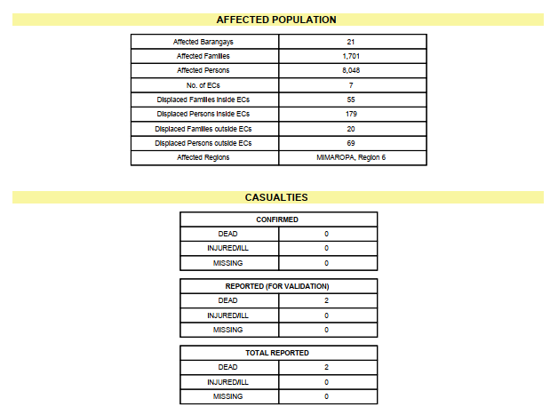
8K
Affected Person
248
Displaced
External Video
News
Human SADDD
- Dead 3
- Missing -
- Injured -
- Affected Person 8,048
- Affected Family 1,701
- Internaly Displaced People 248
- Refugees -
- Evacuation Center (in Country) -
- Evacuation Center (out Of Country) -
House
- Affected Houses 19
- Damage Partial 16
- Totally Damage 3
Infrastructure
- Bridges -
- Number of Roads 10
- Road Distance (km) -
Public
- Schools -
- Health -
- Government Office / Public Facilities -
- Settlements -
- Worship Places -
- Others -
General
Cost
- Local Currency 0.00
- Cost of Damages 12,225,109.00
- Cost of Damages (USD) 240,886.00
- Cost of Assistance -
- Cost of Assistance (USD) -
Agricultural
- Rice Field 942.00
- Other Crops -
- Fish Ponds -
- Cattle -
- Poultries -
- Livestock -
Relevant Disasters
The ASEAN Disaster Information Network (ADINet) is a repository of information concerning hazards and disasters that have happened in the region. The platform is open for public, which means that the public can submit information about any hazard and disaster to the AHA Centre. Thereafter, the AHA Centre will verify and validate any submitted information to ensure the accuracy of the data inputs. The AHA Centre can also add new information when relevant and as necessary. ADINet has been recording disaster information in the region since the AHA Centre was operational in 2012.

Supported by :