Myanmar - Flooding in Southwestern Myanmar
Jun 14, 2018 08:58
Sep 27, 2026 15:17
Location
Coordinate:
20.221129, 94.954857
Administrative:
Magway, Myanmar
Affected Area:
Magway
Hazard
Main : Flood- Inundated Area (km) = fill value here
- Maximum Flood Depth (cm) = fill value here
Description
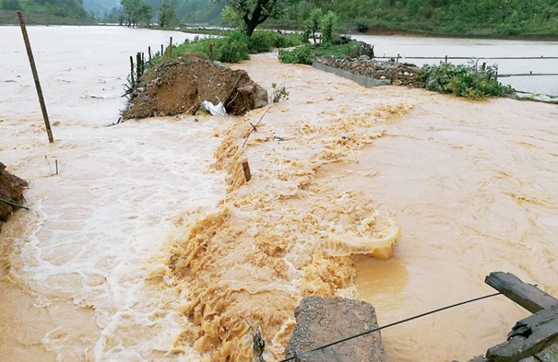
DDM information The causes have concluded about the flood disaster management guide supervised by the Committee of Social Welfare, Minister for Relief and Resettlement of the relevant ministries, Region / State Disaster Management Group, Get local news, social organizations and coordinate the collection, In line with the Ministry‘ policy to be an effective risk management programs for coordination and support services - • Magway Lynn Township, Village (8) in the village (on 12-6-2018) due to water intrusion, a housing (66) Household population (66) (261) moved to the residence to the nearest relative positioning, Dig a hole in the mountain village and the village whether it is on (11-6-2018) Home (7), due to erosion The population of the household (7) (27), given the first move Lynn Township, On land in the village (11-6-2018) Hpaung Taw calm creek (1) to the stream of water swept away and died, Magway Unfortunately a small village on (11-6-2018) in the drinking water due to flooding and erosion, housing (7) The population of the household (7), (25) was facing disaster Township, Village (40) (11-6-2018) (12-6-2018) on the date that it rains on the day of the bridge (approach) damaged boat. Sesame acreage (approximately 6570) • The state, A marble stone on the city (10-6-2018) in the IDPs camps and the destruction of the roof (1) and (3) have been flooding from households (24) (72) of the population, given to transferred to စာသင်ဆောင် Taunggoat The valley near the village (11-6-2018) - launched on the road မိုင်တိုင်အမှတ် (22/4) (20) feet in length on the concrete bridge collapsed about (6) (12-6-2018) Nat Maw-pilot on the main road (120) feet in length between the collapse, destruction The village village road length (approximately 200) broken, The prison in the village of the stairs (12-6-2018) wooden bridge had been broken due to the flow of streams in the year. • Karen Papun township, No. (2) Ward, Heavy-Section on (12-6-2018) in the lacquer due to the river rose, the housing (19) Households (19) of the population (83).. (2) relocation of schools had the accident. • Kayah Rudy Township Swimming caterpillar Village moderator between the villages and the time domain window Saw road transport vehicles due to landslides occurred in temporary shortages last year. • Shan Kyaukme, Heh in the village (11-6-2018) had been living off the bridge collapsed due to heavy rains on the day of accident. • Ayeyarwady ကြံခင်းမြို့, Village (14) (11-6-2018), the frog in the village due to rising rivers and quiet creek water, a housing (98) Household (98) (362) to evacuate the population to move into the homes and the nearest relatives had learned. • The people of your Social Welfare, Ministry of Relief and Resettlement of relief materials, The food value of rice Hardware value, Bottles of drinking water supply and သေဆုံးသူများအတွက် hospitalized after being operated on (11-6-2018) Kamma Township, Flood your household (681) to move from a population (2763) for addressing (6,942,300 / -) worth of rice and food value, Hardware value, Clean drinking water, the Department of Disaster Management Deputy Director-General U Than Htut Swe, a member of your people‘ possession on (13-6-2018), and Addressing the rest of the flood victims in the affected areas (3,466,541 / -) worth of goods and funds from the respective Region / State / District Officer Office officials have been supported either the total (10,408) ------------------------------- Due to heavy rains over Rakhine State, multiple areas have reported flooding with many villages affected. The rivers banks have overflowed due to heavy rainfall which was reported to be 1220cm. The heavy downpour has resulted in many disruption to traffic with dams overflowing and unable to control the water flow. Although most of the townships in Rakhine state since the last week of May, with heavy rains, lowland flooding some quarters in Valley Road landslide occurs. Rain is pretty big. In Sittwe-Yangon road Ann stretch brisk flame of the street, so it is difficult to go. I finally got to go through to get a room, ' one of the passengers came to Yangon to Sittwe, said on June 11. Completely by rain construction Detour bridge where vehicles are difficult to navigate, said a driver from a vehicle. ' States the rain are experiencing any troubles always. I encountered last year. Above, it is pretty much ' the driver said. From vehicles through such a difficult time after arrival, the majority of passengers.
Impact Statistic
1
Dead
2
Missing
3
Injured
3.5K
Affected Person
3.5K
Displaced
Human SADDD
- Dead 1
- Missing 2
- Injured 3
- Affected Person 3,521
- Affected Family 902
- Internaly Displaced People 3,521
- Refugees 0
- Evacuation Center (in Country) -
- Evacuation Center (out Of Country) 0
House
- Affected Houses 950
- Damage Partial 950
- Totally Damage -
Infrastructure
- Bridges 0
- Number of Roads 0
- Road Distance (km) 0.00
Public
- Schools 2
- Health -
- Government Office / Public Facilities 0
- Settlements 0
- Worship Places 0
- Others 0
General
Cost
- Local Currency 0.00
- Cost of Damages 0.00
- Cost of Damages (USD) -
- Cost of Assistance 0.00
- Cost of Assistance (USD) -
Agricultural
- Rice Field 200.00
- Other Crops 0.00
- Fish Ponds 0
- Cattle 0
- Poultries 0
- Livestock 0
Relevant Disasters
The ASEAN Disaster Information Network (ADINet) is a repository of information concerning hazards and disasters that have happened in the region. The platform is open for public, which means that the public can submit information about any hazard and disaster to the AHA Centre. Thereafter, the AHA Centre will verify and validate any submitted information to ensure the accuracy of the data inputs. The AHA Centre can also add new information when relevant and as necessary. ADINet has been recording disaster information in the region since the AHA Centre was operational in 2012.

Supported by :