Myanmar - Flooding in Pakokku Township
Jun 06, 2018 10:03
Sep 27, 2026 15:17
Location
Coordinate:
21.338724, 95.070723
Administrative:
Magway, Myanmar
Affected Area:
Hazard
Main : Flood- Inundated Area (km) = fill value here
- Maximum Flood Depth (cm) = fill value here
Description
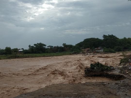
Torrential rain caused more water in Shwe stream in Pakokku Township on June 6 and 7 and seven houses from No.3 Ward are drifted away by rainwater, sources said. No casualties are reported as people and their belongings are moved in advance before water level is increased. “Rainfall in Pakokku is 1.96 inches and it is increased water level in Shwe stream. We have to move five houses and a religious hall,” said the township administrator Myint Saung. A total of 19 houses are relocated as water level is still increased till the afternoon of June 7, according to No.3 ward administrator. A vehicle under repaired in a car workshop is drifted away and the authorities are working hard to prevent flooding. Civic organizations, firefighters and policemen are helping to move houses and Relief and Resettlement Department is providing aid for flood victims. Many houses were drifted away in Shwe stream in October 2011 and more than 100 people were drowned. Some creeps in Myaing and Pakokku townships are joined and became Shwe stream and some dams in Myaing are disposed of water from their outlet pipes to prevent dam burst. Water flooded roads in Pakokku Township caused by torrential rain at the end of May and the locals have the drinking water they needed. A burst occurred at Kawtaw dam in the township caused temporary blockage in roads connecting between Pakokku and Yaw area and Chin Mountain.
Impact Statistic
0
Dead
0
Missing
0
Injured
290.1K
Affected Person
0
Displaced
Human SADDD
- Dead -
- Missing -
- Injured -
- Affected Person 290,139
- Affected Family 58,028
- Internaly Displaced People -
- Refugees 0
- Evacuation Center (in Country) -
- Evacuation Center (out Of Country) 0
House
- Affected Houses 26
- Damage Partial 0
- Totally Damage 26
Infrastructure
- Bridges 0
- Number of Roads 0
- Road Distance (km) 0.00
Public
- Schools -
- Health -
- Government Office / Public Facilities 0
- Settlements 0
- Worship Places 0
- Others 0
General
Cost
- Local Currency 0.00
- Cost of Damages 0.00
- Cost of Damages (USD) -
- Cost of Assistance 0.00
- Cost of Assistance (USD) -
Agricultural
- Rice Field 0.00
- Other Crops 0.00
- Fish Ponds 0
- Cattle 0
- Poultries 0
- Livestock 0
Relevant Disasters
The ASEAN Disaster Information Network (ADINet) is a repository of information concerning hazards and disasters that have happened in the region. The platform is open for public, which means that the public can submit information about any hazard and disaster to the AHA Centre. Thereafter, the AHA Centre will verify and validate any submitted information to ensure the accuracy of the data inputs. The AHA Centre can also add new information when relevant and as necessary. ADINet has been recording disaster information in the region since the AHA Centre was operational in 2012.

Supported by :