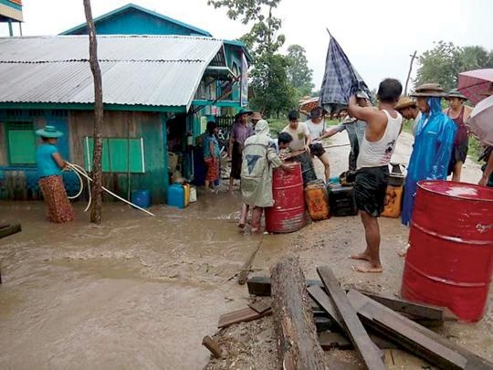
Myanmar - Flooding in Kani Township
Jun 05, 2018 11:44
Sep 27, 2026 15:17
Location
Coordinate:
22.459395, 94.843206
Administrative:
Sagaing, Myanmar
Affected Area:
Sagaing
Hazard
Main : Flood- Inundated Area (km) = fill value here
- Maximum Flood Depth (cm) = fill value here
Description
Torrential rain causes flood in Kani Township, Sagaing Region KALAY- Due to torrential rain, plantations, dams and roads were destroyed in Kani Township, Sagaing Region. Moreover, it caused the bank erosion. “Many plantations and roads are being flooded. Parhe village is still collecting the damaged lists. This year, some parts which never face the flooding are inundated. Southern Parhe village is being flooded. Moreover, the rain flooded Onion, Sesame and Bean plantations. Parhe creek is flooded due to heavy rain so also embankments are broken down. Some villages aren’t phoning while raining,” said MP Tun Tun Win from Kani Township. Furthermore, Parhe creek in Kani Township had swollen and flooded nearby areas yesterday morning. “We have to face torrent rain yearly. But, this year torrent rain is very worst. About 40 houses and paddy strains were flooded. Our cattle are being evacuated to safer places. Six motorbikes were swamped. Rain started from around 11pm of June 5th to yesterday morning. That’s why we can’t control the overflow of water. In our village, there are around 200 houses. At present, we can’t look at the plantations. But, we inspect the damage of roads and gutters. I think plantations will be flooded. At present, no vehicles can drive because roads were seriously damaged. The heavy rain had made the roads very muddy and mountain stream. It is raining about 8 days. Some farmers lost their paddy strains,” said Ahe Myint from Kani Township. Likewise, torrential rain has flooded some wards in Namptlan village, Thibaw Township, northern Shan State. Although Namptlan village had never seen the flooding in the past, the flooding frequently occurs in the village due to forest depletion, according to the locals. “Torrent rain had overflowed on the Mandalay-Lashio Union Highway near Kyaukme Township. We ordered the drivers to pass through the Union Highway systematically aiming to avoid the danger. However, a vehicle fell into the road side avoiding another car. There was no injury. Now, water decreases on the Union Highway,” said Thet Swe from Oriental Highway in Kyaukme Township. Flood has occurred in northern Shan State after continuous downpours and overflowing the torrent rain. --------------- Flooding had destroyed crops of nearly 70,000 acres
Impact Statistic
0
Dead
0
Missing
0
Injured
200
Affected Person
0
Displaced
Human SADDD
- Dead -
- Missing -
- Injured -
- Affected Person 200
- Affected Family 40
- Internaly Displaced People -
- Refugees 0
- Evacuation Center (in Country) -
- Evacuation Center (out Of Country) 0
House
- Affected Houses 40
- Damage Partial 0
- Totally Damage 40
Infrastructure
- Bridges 0
- Number of Roads 0
- Road Distance (km) 0.00
Public
- Schools -
- Health -
- Government Office / Public Facilities 0
- Settlements 0
- Worship Places 0
- Others 0
General
Cost
- Local Currency 0.00
- Cost of Damages 0.00
- Cost of Damages (USD) -
- Cost of Assistance 0.00
- Cost of Assistance (USD) -
Agricultural
- Rice Field 28,327.00
- Other Crops 0.00
- Fish Ponds 0
- Cattle 0
- Poultries 0
- Livestock 0
Relevant Disasters
The ASEAN Disaster Information Network (ADINet) is a repository of information concerning hazards and disasters that have happened in the region. The platform is open for public, which means that the public can submit information about any hazard and disaster to the AHA Centre. Thereafter, the AHA Centre will verify and validate any submitted information to ensure the accuracy of the data inputs. The AHA Centre can also add new information when relevant and as necessary. ADINet has been recording disaster information in the region since the AHA Centre was operational in 2012.

Supported by :