Malaysia, Flash Flood in Penang
Nov 07, 2017 05:31
Sep 27, 2026 15:11
Location
Coordinate:
5.311474, 100.270814
Administrative:
Pulau Pinang, Malaysia
Affected Area:
Hazard
Main : Flood- Inundated Area (km) = fill value here
- Maximum Flood Depth (cm) = fill value here
Description
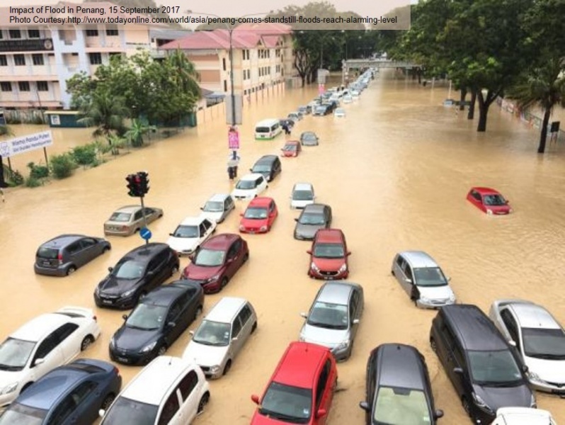
UPDATE on 3 November 2017 Penang Government will make aid payment of RM 400 to victims of flood on 15 September 2017, which inundated 100 areas in Penang State. Heavy rainfall that showered Penang Island on Thursday (14 Sept 2017) night has led to massive floods and landslides, resulting in major disruptions in the city. Several landslide spots were identified in Medan Fettes and Paya Terubong. About 100 areas in five districts have been affected with the worst situation at northeast district of Penang. Most of these areas were flooded between 0.1m and 0.6m, causing massive traffic gridlock. According to local authorities, the overnight downpour produced the highest amount of rainfall ever recorded in the state‘ history at 270mm, as measured from Air Itam dam on Friday morning. The State‘ Drainage and Irrigation Department said the water levels for rivers Sungai Pinang and Sungai Air Itam measured record highs of 3.2m and 7.3m respectively as of Friday morning (15 Sept).
Impact Statistic
0
Dead
0
Missing
0
Injured
0
Affected Person
0
Displaced
Human SADDD
- Dead -
- Missing -
- Injured -
- Affected Person -
- Affected Family 19
- Internaly Displaced People -
- Refugees 0
- Evacuation Center (in Country) 1
- Evacuation Center (out Of Country) 0
House
- Affected Houses 0
- Damage Partial 0
- Totally Damage 200
Infrastructure
- Bridges 0
- Number of Roads 0
- Road Distance (km) 0.00
Public
- Schools -
- Health -
- Government Office / Public Facilities 0
- Settlements 0
- Worship Places 0
- Others 0
General
Cost
- Local Currency 0.00
- Cost of Damages 0.00
- Cost of Damages (USD) -
- Cost of Assistance 0.00
- Cost of Assistance (USD) -
Agricultural
- Rice Field 0.00
- Other Crops 0.00
- Fish Ponds 0
- Cattle 0
- Poultries 0
- Livestock 0
Relevant Disasters
The ASEAN Disaster Information Network (ADINet) is a repository of information concerning hazards and disasters that have happened in the region. The platform is open for public, which means that the public can submit information about any hazard and disaster to the AHA Centre. Thereafter, the AHA Centre will verify and validate any submitted information to ensure the accuracy of the data inputs. The AHA Centre can also add new information when relevant and as necessary. ADINet has been recording disaster information in the region since the AHA Centre was operational in 2012.

Supported by :