Indonesia, M6.0 Earthquake in North Tapanuli Regency (North Sumatra)
Oct 01, 2022 02:28
Sep 27, 2026 15:21
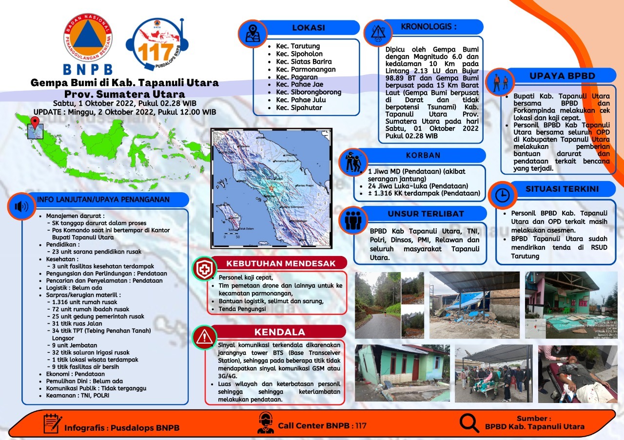
Location
Coordinate:
2.13, 98.89
Administrative:
Sumatera Utara, Indonesia
Affected Area:
Sumatera Utara
Hazard
Main : Earthquake- Latitude = fill value here
- Longitude = fill value here
- Magnitude = fill value here
- Mechanism = fill value here
- Depth (km) = fill value here
- Magnitude Type = fill value here
- Intensity Scale = fill value here
- Maximum Intensity = fill value here
Description
Magnitude : 6.0 SR
Date : 01-Oct-2022
Earthquake Time : 02:28:41 WIB
Latitude : 2.13 LU
Longitude : 98.89 East Longitude
Depth : 10 Km
Aftershocks
Magnitude: 5.1 SR
Date : 01-Oct-2022
Earthquake Time : 02:50:35 WIB
Latitude : 2.05 LU
Longitude : 98.99 East Longitude
Depth : 10 Km
Magnitude: 5.0 SR
Date : 01-Oct-2022
Earthquake Time : 03:37:40 WIB
Latitude : 2.03 LU
Longitude : 98.97 East Longitude
Depth : 10 Km
Location:
Kab. Tapanuli Utara
• Kec. Tarutung : Ds. Sosunggulon, Ds. Parbaju Toruan, Ds. Siraja Oloan. Ds. Hapoltahan, Ds. Parbaju Julu, Ds. Siandorandor, Ds. Hutatoruan V, Ds. Hutatoruan X, Ds. Parbubu Pea, Ds. Hutatoruan VII, Ds. Parbubu Dolok, Ds. Partali Julu, Ds. Hutatoruan XI, Ds. Simamora
• Kec. Sipoholon : Ds. Situmeang Habinsaran, Ds. Hutauruk, Ds. Hutaraja, Ds. Hutaraja Hasundutan, Ds. Situmeang Hasundutan, Ds. Pagar Batu, Ds. Sipahutar, Ds. Rurajulu Toruan, Ds. Rurajulu Dolok, Ds. Simanungkalit, Ds. Hutaraja Simanungkalit, Ds. Tapian Nauli, Ds. Lobusingkam, Ds. Hutauruk Hasundutan
• Kec. Siatas Barita : Ds. Pansurnapitu, Ds. Sitompul, Ds. Sangkaran, Ds. Lumban Siagian Jae, Ds. Lumban Siagian Julu, Ds. Simorangkir Habinsaran, Ds. Enda Portibi, Ds. Simorangkir Julu, Ds. Siraja Hutagalung, Ds. Lobu Hole, Ds. Sidagal
• Kec. Parmonangan
• Kec. Pagaran : Ds. Banua Luhu, Ds. Sipultak, Ds. Pagaran 1 Sibaragas, Ds. Parhorboan, Ds. Dolok Saribu, Ds. Lumban Silintong, Ds. Lumban Inaina, Ds. Simamora Hasibuan, Ds. Hasibuan, Ds. Lubis, Ds. Strat Lapo, Ds. Sibirik, Ds. Onan Simbara, Ds. Sosor Sitamba, Ds. Peatingko 1, Ds. Sosor Talun, Ds. Simpang Tolu, Ds. Peatingko 2, Ds. Hutagurgur, Ds. Naga Timbul Sipultak, Ds. Matanggor, Ds. Bahal Bagot
• Kec. Pahae Jae : Ds. Sitoluompu, Ds. Pasar Sarulla
• Kec. Siborongborong : Ds. Sitabo-tabo, Ds. Pabiaran, Ds. Pariksabungan
• Kec. Pahae Julu : Ds. Lontung Dolok, Ds. Lumbah Garaga
• Kec. Sipahutar : Ds. Sipahutar
Effort :
• District Head. North Tapanuli together with BPBD and Forkopimda conducted a site check and a quick review
• BPBD personnel of North Tapanuli Regency together with all OPDs in North Tapanuli Regency are conducting emergency assistance and data collection related to the disaster that occurred.
• North Tapanuli BPBD has set up a tent at Tarutung Hospital
Latest Condition:
• Kab. BPBD personnel. North Tapanuli and related OPD are still conducting assessments.
• North Tapanuli BPBD has set up a tent at Tarutung Hospital
Urgent needs :
• Rapid review personnel
• Drone mapping team and others to Parmonangan sub-district
• Logistics assistance, blankets and gloves
• Tent
Constraint :
• The size of the area and limited personnel, resulting in delays in collecting data.
Informed By:
BNPB PUSDALOPS
Complaint Number / Call Center : 117 (Toll Free)
Instagram : pusdalops_bnpb
Twitter : @Bnpbpusdalops
Date : 01-Oct-2022
Earthquake Time : 02:28:41 WIB
Latitude : 2.13 LU
Longitude : 98.89 East Longitude
Depth : 10 Km
Aftershocks
Magnitude: 5.1 SR
Date : 01-Oct-2022
Earthquake Time : 02:50:35 WIB
Latitude : 2.05 LU
Longitude : 98.99 East Longitude
Depth : 10 Km
Magnitude: 5.0 SR
Date : 01-Oct-2022
Earthquake Time : 03:37:40 WIB
Latitude : 2.03 LU
Longitude : 98.97 East Longitude
Depth : 10 Km
Location:
Kab. Tapanuli Utara
• Kec. Tarutung : Ds. Sosunggulon, Ds. Parbaju Toruan, Ds. Siraja Oloan. Ds. Hapoltahan, Ds. Parbaju Julu, Ds. Siandorandor, Ds. Hutatoruan V, Ds. Hutatoruan X, Ds. Parbubu Pea, Ds. Hutatoruan VII, Ds. Parbubu Dolok, Ds. Partali Julu, Ds. Hutatoruan XI, Ds. Simamora
• Kec. Sipoholon : Ds. Situmeang Habinsaran, Ds. Hutauruk, Ds. Hutaraja, Ds. Hutaraja Hasundutan, Ds. Situmeang Hasundutan, Ds. Pagar Batu, Ds. Sipahutar, Ds. Rurajulu Toruan, Ds. Rurajulu Dolok, Ds. Simanungkalit, Ds. Hutaraja Simanungkalit, Ds. Tapian Nauli, Ds. Lobusingkam, Ds. Hutauruk Hasundutan
• Kec. Siatas Barita : Ds. Pansurnapitu, Ds. Sitompul, Ds. Sangkaran, Ds. Lumban Siagian Jae, Ds. Lumban Siagian Julu, Ds. Simorangkir Habinsaran, Ds. Enda Portibi, Ds. Simorangkir Julu, Ds. Siraja Hutagalung, Ds. Lobu Hole, Ds. Sidagal
• Kec. Parmonangan
• Kec. Pagaran : Ds. Banua Luhu, Ds. Sipultak, Ds. Pagaran 1 Sibaragas, Ds. Parhorboan, Ds. Dolok Saribu, Ds. Lumban Silintong, Ds. Lumban Inaina, Ds. Simamora Hasibuan, Ds. Hasibuan, Ds. Lubis, Ds. Strat Lapo, Ds. Sibirik, Ds. Onan Simbara, Ds. Sosor Sitamba, Ds. Peatingko 1, Ds. Sosor Talun, Ds. Simpang Tolu, Ds. Peatingko 2, Ds. Hutagurgur, Ds. Naga Timbul Sipultak, Ds. Matanggor, Ds. Bahal Bagot
• Kec. Pahae Jae : Ds. Sitoluompu, Ds. Pasar Sarulla
• Kec. Siborongborong : Ds. Sitabo-tabo, Ds. Pabiaran, Ds. Pariksabungan
• Kec. Pahae Julu : Ds. Lontung Dolok, Ds. Lumbah Garaga
• Kec. Sipahutar : Ds. Sipahutar
Effort :
• District Head. North Tapanuli together with BPBD and Forkopimda conducted a site check and a quick review
• BPBD personnel of North Tapanuli Regency together with all OPDs in North Tapanuli Regency are conducting emergency assistance and data collection related to the disaster that occurred.
• North Tapanuli BPBD has set up a tent at Tarutung Hospital
Latest Condition:
• Kab. BPBD personnel. North Tapanuli and related OPD are still conducting assessments.
• North Tapanuli BPBD has set up a tent at Tarutung Hospital
Urgent needs :
• Rapid review personnel
• Drone mapping team and others to Parmonangan sub-district
• Logistics assistance, blankets and gloves
• Tent
Constraint :
• The size of the area and limited personnel, resulting in delays in collecting data.
Informed By:
BNPB PUSDALOPS
Complaint Number / Call Center : 117 (Toll Free)
Instagram : pusdalops_bnpb
Twitter : @Bnpbpusdalops
Impact Statistic
1
Dead
0
Missing
24
Injured
13.1K
Affected Person
0
Displaced
External Video
News
Human SADDD
- Dead 1
- Missing -
- Injured 24
- Affected Person 13,130
- Affected Family 2,626
- Internaly Displaced People -
- Refugees -
- Evacuation Center (in Country) -
- Evacuation Center (out Of Country) -
House
- Affected Houses 2,626
- Damage Partial -
- Totally Damage -
Infrastructure
- Bridges 9
- Number of Roads 31
- Road Distance (km) -
Public
- Schools 21
- Health 2
- Government Office / Public Facilities 24
- Settlements -
- Worship Places 71
- Others 36
General
Cost
- Local Currency 0.00
- Cost of Damages -
- Cost of Damages (USD) -
- Cost of Assistance -
- Cost of Assistance (USD) -
Agricultural
- Rice Field -
- Other Crops -
- Fish Ponds -
- Cattle -
- Poultries -
- Livestock -
Relevant Disasters
The ASEAN Disaster Information Network (ADINet) is a repository of information concerning hazards and disasters that have happened in the region. The platform is open for public, which means that the public can submit information about any hazard and disaster to the AHA Centre. Thereafter, the AHA Centre will verify and validate any submitted information to ensure the accuracy of the data inputs. The AHA Centre can also add new information when relevant and as necessary. ADINet has been recording disaster information in the region since the AHA Centre was operational in 2012.

Supported by :