Indonesia, M 6.5 Earthquake in Ambon
Sep 26, 2019 05:23
Sep 27, 2026 15:17
Location
Coordinate:
-3.423979, 128.643007
Administrative:
Maluku, Indonesia
Affected Area:
Maluku
Hazard
Main : Earthquake- Latitude = fill value here
- Longitude = fill value here
- Magnitude = fill value here
- Mechanism = fill value here
- Depth (km) = fill value here
- Magnitude Type = fill value here
- Intensity Scale = fill value here
- Maximum Intensity = fill value here
Description
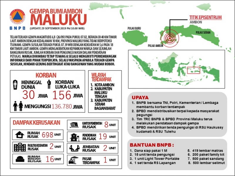
AKARTA - The Mayor of Ambon set an emergency response period after the earthquake for 14 days, starting from September 26, 2019 to October 9, 2019. Ambon City was one of the areas affected by the M 6.5 earthquake that occurred on Thursday (26/5). During the emergency response period, the Ambon City Earthquake Disaster Response Command Post was tasked with coordinating all elements for emergency response in its administrative area. The earthquake with a depth of 10 km had shaken several districts such as Baguala, Ambon Bay, Sirimau, Nusaniwe and Ambon City. Data from the Maluku Province BPBD Pusdalops as of today (9/29) recorded 10 deaths and 31 injuries. Meanwhile, the total death toll from three districts in Maluku Province is 30 people. The highest casualties in Central Maluku Regency were 14 people, Ambon City 10 and West Seram (SBB) 6. While injured victims, the total number reached 156 people with details of Central Maluku 108, Ambon City 31 and SBB 17. After the earthquake also caused displacement of residents. They displaced a total of 244,780 people, with details of SBB 109,661 people, 108,000 Central Maluku and Ambon City 27,119. While the damage data on houses are still being carried out; data on damaged houses in Ambon City amounted to 374 units with details of 173 slightly damaged (RR), 74 moderately damaged (RS) and 74 severely damaged (RB). Damages to the SBB area included 31 RRs, 163 hospitals and 106 RB. The Maluku Province BPBD has set up two family tents in the yard of the Haulussy General Hospital, Ambon City and Tulehu Hospital, Central Maluku. In addition, the local government also distributes tarps to affected communities. Data collection efforts on the ground are still being carried out by the Maluku Province BPBD rapid reaction team. One of the data collection efforts is to identify the evacuation points. Meanwhile, concentration points have been identified in Waai Village such as in the Waai Waterfall region, Ujung Batu and Batu Dua Hamlets. While in Ambon City, survivors were concentrated in SMA Siliwangi, Graveyard of SMA 9, and SMA 9. Seeing the latest conditions, some challenges are still faced in handling emergencies. One of them needs intensive efforts to conduct socialization to the community to immediately return to their respective homes. BNPB has sent a support team in the management of the command post and logistical and equipment support that has arrived in Maluku. On the other hand, the TNI operated the field hospital on the Darussalam Campus, Central Maluku. Agus Wibowo Plt. Head of BNPB Data, Information and Public Relations Center
Impact Statistic
30
Dead
0
Missing
156
Injured
224.8K
Affected Person
224.8K
Displaced
External Video
News
Human SADDD
- Dead 30
- Missing -
- Injured 156
- Affected Person 224,780
- Affected Family 48,956
- Internaly Displaced People 224,780
- Refugees -
- Evacuation Center (in Country) -
- Evacuation Center (out Of Country) -
House
- Affected Houses 698
- Damage Partial 518
- Totally Damage 180
Infrastructure
- Bridges -
- Number of Roads -
- Road Distance (km) -
Public
- Schools -
- Health -
- Government Office / Public Facilities -
- Settlements -
- Worship Places -
- Others -
General
Cost
- Local Currency 0.00
- Cost of Damages -
- Cost of Damages (USD) -
- Cost of Assistance -
- Cost of Assistance (USD) -
Agricultural
- Rice Field -
- Other Crops -
- Fish Ponds -
- Cattle -
- Poultries -
- Livestock -
Relevant Disasters
The ASEAN Disaster Information Network (ADINet) is a repository of information concerning hazards and disasters that have happened in the region. The platform is open for public, which means that the public can submit information about any hazard and disaster to the AHA Centre. Thereafter, the AHA Centre will verify and validate any submitted information to ensure the accuracy of the data inputs. The AHA Centre can also add new information when relevant and as necessary. ADINet has been recording disaster information in the region since the AHA Centre was operational in 2012.

Supported by :