Indonesia, Earthquake in Central Maluku, Maluku
Jun 16, 2021 11:43
Sep 27, 2026 15:18
Location
Coordinate:
-3.39, 129.56
Administrative:
Maluku, Indonesia
Affected Area:
Maluku
Hazard
Main : Earthquake- Latitude = fill value here
- Longitude = fill value here
- Magnitude = fill value here
- Mechanism = fill value here
- Depth (km) = fill value here
- Magnitude Type = fill value here
- Intensity Scale = fill value here
- Maximum Intensity = fill value here
Description
Update as of 17 June 2021, 10.00 GMT+7
Fatalities :
• 871 families/ 4,112 people displaced
Material Losses:
• 150 housing units
• 3 units of houses of worship damaged
Effort :
• BPBD Kab. Central Maluku has directed TRC personnel to conduct a rapid assessment on site
Up-to-date Condition:
- Some people have returned to their homes
Earthquake Impact:
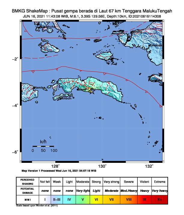
The shaking of this earthquake was felt in Tehoru, Masohi, Bula, Kairatu, Saparua, OH III - IV MMI (During the day it was felt by many people in the house), Ambon Island II-III MMI ( Vibration felt real in the house. The vibration felt like a truck passed). Until now, BPBD and local communities have reported the impact of damage to several houses, one of which is the church fence in Sounulu village, Tehoru District as a result of the earthquake. BPBD is still continuing to record the condition of the impact of this earthquake.
Aftershocks:
Until Wednesday, June 16, 2021 at 14:35 WIB, the results of BMKG monitoring have occurred 16 (sixteen) aftershock earthquakes with a magnitude range of 1.9 - 3.7.
BMKG recommendations:
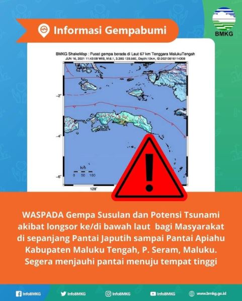
To the community, especially in areas along the Japutih Coast to Atiahu Beach, Central Maluku Regency, P. Seram, Maluku to BE AWARE of aftershocks and potential tsunamis due to landslides to/under the sea, then immediately move away from the coast to high places if you feel the earthquake shock is strong enough.
BMKG continues to monitor the aftershocks that occur and their impact on sea level rise.
Field Constraints:
- The difficulty of to access the evacuation camp
- Difficulty accessing cellphone signal
Date : 16-Jun-21
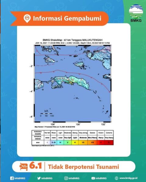
Time : 11:43:08 WIB
Earthquake Strength : 6.1 SR
Depth: 10KM
Latitude : 3.39 LS
Longitude : 129.56 BT
Normal Fault Mechanism
Location :
67 km southeast of CENTRAL MALUKU
Fatalities :
• Yaputi Village: residents fled to higher ground (Some have returned to their homes)
Material Losses:
• 125 housing units
• 3 units of houses of worship damaged
Information :
Regency. Central Maluku :
• Strong earthquake felt in kab. Central Maluku ± 3-5 seconds
• People panicked and ran out of the house
Regency. Eastern Seram:
• Strong earthquake felt in Kab. Eastern Seram ± 3-5 seconds
• People panicked and ran out of the house
Ambon City:
• Earthquake felt weak in Ambon City ± 1-3 seconds
Regency. West Seram:
• Strong earthquake felt in Kec. Kai Queen Kab. West Seram ± 3-5 seconds
• People panicked and ran out of the house
Effort :
• District BPBD. Central Maluku has directed TRC personnel to conduct a rapid assessment on site
Latest Condition:
- Some people have returned to their homes
Field Constraints:
- Medan is difficult to find refugee camps
- Difficulty accessing cellphone signal sinyal
Informed By:
PUSDALOPS-PB BNPB
Complaint Number / Call Center : 117 (Toll Free)
Instagram : pusdalops_bnpb
Twitter : @Bnpbpusdalops
Fatalities :
• 871 families/ 4,112 people displaced
Material Losses:
• 150 housing units
• 3 units of houses of worship damaged
Effort :
• BPBD Kab. Central Maluku has directed TRC personnel to conduct a rapid assessment on site
Up-to-date Condition:
- Some people have returned to their homes
Earthquake Impact:
The shaking of this earthquake was felt in Tehoru, Masohi, Bula, Kairatu, Saparua, OH III - IV MMI (During the day it was felt by many people in the house), Ambon Island II-III MMI ( Vibration felt real in the house. The vibration felt like a truck passed). Until now, BPBD and local communities have reported the impact of damage to several houses, one of which is the church fence in Sounulu village, Tehoru District as a result of the earthquake. BPBD is still continuing to record the condition of the impact of this earthquake.
Aftershocks:
Until Wednesday, June 16, 2021 at 14:35 WIB, the results of BMKG monitoring have occurred 16 (sixteen) aftershock earthquakes with a magnitude range of 1.9 - 3.7.
BMKG recommendations:
To the community, especially in areas along the Japutih Coast to Atiahu Beach, Central Maluku Regency, P. Seram, Maluku to BE AWARE of aftershocks and potential tsunamis due to landslides to/under the sea, then immediately move away from the coast to high places if you feel the earthquake shock is strong enough.
BMKG continues to monitor the aftershocks that occur and their impact on sea level rise.
Field Constraints:
- The difficulty of to access the evacuation camp
- Difficulty accessing cellphone signal
Date : 16-Jun-21
Time : 11:43:08 WIB
Earthquake Strength : 6.1 SR
Depth: 10KM
Latitude : 3.39 LS
Longitude : 129.56 BT
Normal Fault Mechanism
Location :
67 km southeast of CENTRAL MALUKU
Fatalities :
• Yaputi Village: residents fled to higher ground (Some have returned to their homes)
Material Losses:
• 125 housing units
• 3 units of houses of worship damaged
Information :
Regency. Central Maluku :
• Strong earthquake felt in kab. Central Maluku ± 3-5 seconds
• People panicked and ran out of the house
Regency. Eastern Seram:
• Strong earthquake felt in Kab. Eastern Seram ± 3-5 seconds
• People panicked and ran out of the house
Ambon City:
• Earthquake felt weak in Ambon City ± 1-3 seconds
Regency. West Seram:
• Strong earthquake felt in Kec. Kai Queen Kab. West Seram ± 3-5 seconds
• People panicked and ran out of the house
Effort :
• District BPBD. Central Maluku has directed TRC personnel to conduct a rapid assessment on site
Latest Condition:
- Some people have returned to their homes
Field Constraints:
- Medan is difficult to find refugee camps
- Difficulty accessing cellphone signal sinyal
Informed By:
PUSDALOPS-PB BNPB
Complaint Number / Call Center : 117 (Toll Free)
Instagram : pusdalops_bnpb
Twitter : @Bnpbpusdalops
Impact Statistic
0
Dead
0
Missing
0
Injured
8.8K
Affected Person
8.8K
Displaced
Human SADDD
- Dead -
- Missing -
- Injured -
- Affected Person 8,821
- Affected Family 1,764
- Internaly Displaced People 8,821
- Refugees -
- Evacuation Center (in Country) -
- Evacuation Center (out Of Country) -
House
- Affected Houses 233
- Damage Partial 233
- Totally Damage -
Infrastructure
- Bridges -
- Number of Roads -
- Road Distance (km) -
Public
- Schools -
- Health -
- Government Office / Public Facilities -
- Settlements -
- Worship Places 3
- Others -
General
Cost
- Local Currency 0.00
- Cost of Damages -
- Cost of Damages (USD) -
- Cost of Assistance -
- Cost of Assistance (USD) -
Agricultural
- Rice Field -
- Other Crops -
- Fish Ponds -
- Cattle -
- Poultries -
- Livestock -
Relevant Disasters
The ASEAN Disaster Information Network (ADINet) is a repository of information concerning hazards and disasters that have happened in the region. The platform is open for public, which means that the public can submit information about any hazard and disaster to the AHA Centre. Thereafter, the AHA Centre will verify and validate any submitted information to ensure the accuracy of the data inputs. The AHA Centre can also add new information when relevant and as necessary. ADINet has been recording disaster information in the region since the AHA Centre was operational in 2012.

Supported by :