Indonesia, Earthquake in Bali
Jul 17, 2019 09:08
Sep 27, 2026 15:17
Location
Coordinate:
-8.579325, 115.261659
Administrative:
Bali, Indonesia
Affected Area:
Bali
Hazard
Main : Earthquake- Latitude = fill value here
- Longitude = fill value here
- Magnitude = fill value here
- Mechanism = fill value here
- Depth (km) = fill value here
- Magnitude Type = fill value here
- Intensity Scale = fill value here
- Maximum Intensity = fill value here
Description
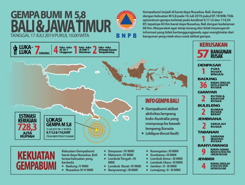
Tuesday, July 16, 2019, at 07.18.35 WIB, the South Indian Ocean region of Bali-Nusa Tenggara was rocked by a tectonic earthquake. The BMKG analysis results show that the initial information on this earthquake has the power M = 6 which is then updated to M = 5.8. The epicenter of the earthquake is located at 9.08 LS and 114.55 BT coordinates, or precisely located at sea at a distance of 80 km south of Kota Negara, Jembrana Regency, Bali Province at a depth of 104 km. Southern earthquake in Java-Bali-Nusa Tenggara, taking into account the location of the epicenter and the depth of the hypocenter, it seems that a moderate depth earthquake is caused by the subduction activity of the Indo-Australian Plate which infiltrated beneath the Eurasian Plate. The results of the analysis of the source mechanism indicate that this earthquake was produced by rock deformation with a sloping thrust fault mechanism. The earthquake was reported to be felt in the MMI Badung area, MMI Nusa Dua IV-V, Denpasar, Mataram, Central Lombok, West Lombok IV MMI, Banyuwangi, Karangkates, Sumbawa, East Lombok, North Lombok III MMI, Jember, Lumajang II- III MMI . Until now there have been no reports of damage caused by the earthquake. The modeling results show that the earthquake did not have a tsunami potential As of 7:50 a.m. WIB, BMKG monitoring results have not shown aftershock activity. People are encouraged to remain calm and not be affected by problems that cannot be justified. Communities are encouraged to remain calm and not be affected by problems that cannot be justified. To avoid buildings that are cracked or damaged by an earthquake. Check and make sure your building is earthquake resistant, or there is no damage due to earthquake vibrations that endanger the stability of the building before you return home. Ensure that official information is only sourced from BMKG which is distributed through an officially verified communication channel (Instagram / Twitter @infoBMKG), website (http://www.bmkg.go.id or inatews.bmkg.go.id), or through Mobile Application (iOS and Android): wrs-bmkg (user: local government, pwd: pemda-bmkg) or infobmkg. Jakarta, July 16, 2019 Head of the BMKG Earthquake and Tsunami Center RAHMAT TRIYONO, S.T., Dipl. Seis, M.Sc.
Impact Statistic
0
Dead
0
Missing
7
Injured
28
Affected Person
0
Displaced
External Video
News
Human SADDD
- Dead -
- Missing -
- Injured 7
- Affected Person 28
- Affected Family 7
- Internaly Displaced People -
- Refugees -
- Evacuation Center (in Country) -
- Evacuation Center (out Of Country) -
House
- Affected Houses 7
- Damage Partial -
- Totally Damage 7
Infrastructure
- Bridges -
- Number of Roads -
- Road Distance (km) -
Public
- Schools -
- Health -
- Government Office / Public Facilities -
- Settlements -
- Worship Places -
- Others 50
General
Cost
- Local Currency 0.00
- Cost of Damages -
- Cost of Damages (USD) -
- Cost of Assistance -
- Cost of Assistance (USD) -
Agricultural
- Rice Field -
- Other Crops -
- Fish Ponds -
- Cattle -
- Poultries -
- Livestock -
Relevant Disasters
The ASEAN Disaster Information Network (ADINet) is a repository of information concerning hazards and disasters that have happened in the region. The platform is open for public, which means that the public can submit information about any hazard and disaster to the AHA Centre. Thereafter, the AHA Centre will verify and validate any submitted information to ensure the accuracy of the data inputs. The AHA Centre can also add new information when relevant and as necessary. ADINet has been recording disaster information in the region since the AHA Centre was operational in 2012.

Supported by :