Indonesia, Banten Earthquake
Jan 26, 2018 18:00
Sep 27, 2026 15:11
Location
Coordinate:
-7.23, 105.9
Administrative:
Banten, Indonesia
Affected Area:
Jawa Barat, Jakarta Raya, Banten
Hazard
Main : Earthquake- Latitude = fill value here
- Longitude = fill value here
- Magnitude = fill value here
- Mechanism = fill value here
- Depth (km) = fill value here
- Magnitude Type = fill value here
- Intensity Scale = fill value here
- Maximum Intensity = fill value here
Description
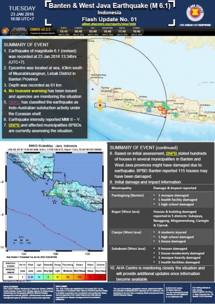
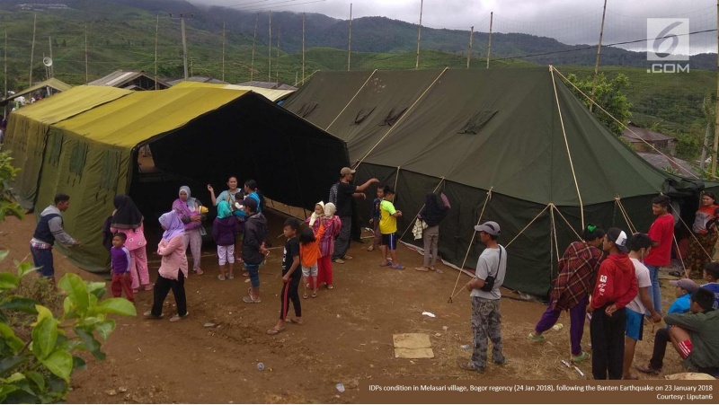
Update as of 26 January 2018 = National Disaster Management Authority (BNPB) reported: 1) In total 73 districts in 9 cities/regencies of 3 provinces (Banten, West Java and Jakarta) were affected. 2) 11 persons injured 3) 2,760 houses damaged; 291 heavy damage, 575 moderate damage, 1,894 light damage. 3a) Cianjur regency: 13 houses damaged 3b) Sukabumi regency: 1,525 houses damaged 3c) Bogor regency: 89 houses damaged 3d) Bogor city: 3 houses damaged 3e) Pandeglang regency: 8 houses damaged 3f) Lebak regency: 1,118 houses damaged 3g) Serang regency: 4 houses damaged 4) Damage on public facilities: 7 religious facilities, 2 health facilities, 17 education facilities, 6 government buildings and 63 other public facilities. 5) Official Emergency response period: 23 January to 5 February 2018. 6) BNPB continues to provide assistance. Head of BNPB Willem Rampangilei has handed over logistics assistance in the value of Rp. 302.9 million to Lebak BPBD in the form of 25 packs clothing, 20 plastic sheet rolls, 3,000 pieces of plastic bags, 5 sheet body bags, 300 school supplies packages, 160 cutlery packages, 140 recreational packages, 40 family kitchen kits, 45 packages of kids ware, 10 packages of family kit and 10 packages of family health kit. The Head of BNPB continues monitoring the impact and earthquake response in Lebak District. 7) BNPB emphasizes that the local government is the key actor for emergency response, provision of logistics for the affected people and compilation data on damaged houses and building for further immediate rehabilitation and reconstruction. = Original report = Tuesday, January 23, 2018, at 13:34:53 pm, South Indian Ocean Java region rocked by tectonic earthquake. The BMKG analysis shows that the earthquake of magnitude M = 6.1 occurs with epicenter coordinates at 7.23 LS and 105.9 BT, or precisely located at sea at 43 km south of Muarabinuangeun City, Lebak District, Banten Province at depth of 61 km . The impact of earthquakes depicted by the BMKG shakemap map shows that the impact of earthquake in the form of potential shocks is felt in Jakarta, South Tangerang, Bogor, II SIG-BMKG (IV-V MMI). This southern-Java-Bali-Nusa Tenggara earthquake is classified as a shallow depth of earthquake due to Indo-Australian subduction activity under the Eurasian Shelf. Until around 13:46 pm, the monitoring results BMKG has not shown any activity aftershock earthquake ( aftershock ). To the people around the area of Cilangkahan Regency are encouraged to remain calm and not be affected by issues that can not be justified truth. * Jakarta, January 23, 2018
Impact Statistic
0
Dead
0
Missing
11
Injured
13.8K
Affected Person
0
Displaced
Human SADDD
- Dead -
- Missing -
- Injured 11
- Affected Person 13,800
- Affected Family 2,760
- Internaly Displaced People -
- Refugees 0
- Evacuation Center (in Country) -
- Evacuation Center (out Of Country) 0
House
- Affected Houses 2,760
- Damage Partial 2,469
- Totally Damage 291
Infrastructure
- Bridges 0
- Number of Roads 0
- Road Distance (km) 0.00
Public
- Schools 17
- Health 2
- Government Office / Public Facilities 6
- Settlements 0
- Worship Places 7
- Others 0
General
Cost
- Local Currency 0.00
- Cost of Damages 0.00
- Cost of Damages (USD) -
- Cost of Assistance 302,900,000.00
- Cost of Assistance (USD) 22,788.00
Agricultural
- Rice Field 0.00
- Other Crops 0.00
- Fish Ponds 0
- Cattle 0
- Poultries 0
- Livestock 0
Relevant Disasters
The ASEAN Disaster Information Network (ADINet) is a repository of information concerning hazards and disasters that have happened in the region. The platform is open for public, which means that the public can submit information about any hazard and disaster to the AHA Centre. Thereafter, the AHA Centre will verify and validate any submitted information to ensure the accuracy of the data inputs. The AHA Centre can also add new information when relevant and as necessary. ADINet has been recording disaster information in the region since the AHA Centre was operational in 2012.

Supported by :