Indonesia - Earthquake in Sarmi, Papua Province
Jun 15, 2018 07:57
Sep 27, 2026 15:17
Location
Coordinate:
-1.970007, 138.892542
Administrative:
Papua, Indonesia
Affected Area:
Papua
Hazard
Main : Earthquake- Latitude = fill value here
- Longitude = fill value here
- Magnitude = fill value here
- Mechanism = fill value here
- Depth (km) = fill value here
- Magnitude Type = fill value here
- Intensity Scale = fill value here
- Maximum Intensity = fill value here
Description
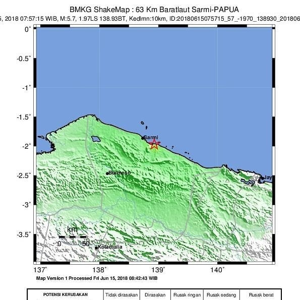
3 HEAVY PEOPLE AND 118 HOUSE DAMAGES DUE TO EARTHQUAKE 5.7 SR IN SARMI The tectonic earthquake with a strength of 5.7 SR shook the area of Sarmi Regency on 15/6/2018 at 07.57 WIB. BMKG reported the earthquake with epicenter located at coordinates 1.93 LS and 138.93 BT, or precisely located at sea near the coast at a distance of 67 km northwest of Sarmi, Papua Province at a depth of 10 km. Considering the location of the epicenter and the depth of the hypocenter, it appears that this umi gempab belongs to the shallow earthquake classification resulting from the subduction activity of the Pacific Plate in New Guinea Trench north of Jayapura. BMKG analysis results, the source mechanism indicates that this earthquake is triggered by tilting enlargement which is a commission between horizontal and upward movement (oblique-thrust). The earthquake is not a potential tsunami. People around Sarmi feel a strong shock for 2-3 seconds. People panicked and scattered outside the house. Temporary report from BPBD Kabupaten Sarmi there are 3 people seriously injured due to crashing house ruins. As many as 118 houses were damaged, 86 houses were severely damaged and 32 houses were slightly damaged. BPBD Kabupaten Sarmi deployed a rapid reaction team to collect data collection. The main obstacle is the distance and the road to the affected location is in a state of serious damage, making it difficult for rapid reaction teams to collect data and distribute aid. Distance between districts is far apart and access is limited. Data collection is still done by BPBD. BNPB posts continue to monitor and coordinate with BPBD Kabupaten Sarmi. @sutopopurwo Head of Information Data and Public Relations Center of BNPB # earthquake # earthquake
Impact Statistic
0
Dead
0
Missing
3
Injured
590
Affected Person
0
Displaced
Human SADDD
- Dead -
- Missing -
- Injured 3
- Affected Person 590
- Affected Family 118
- Internaly Displaced People -
- Refugees 0
- Evacuation Center (in Country) -
- Evacuation Center (out Of Country) 0
House
- Affected Houses 118
- Damage Partial 32
- Totally Damage 86
Infrastructure
- Bridges 0
- Number of Roads 0
- Road Distance (km) 0.00
Public
- Schools -
- Health -
- Government Office / Public Facilities 0
- Settlements 0
- Worship Places 0
- Others 0
General
Cost
- Local Currency 0.00
- Cost of Damages 0.00
- Cost of Damages (USD) -
- Cost of Assistance 0.00
- Cost of Assistance (USD) -
Agricultural
- Rice Field 0.00
- Other Crops 0.00
- Fish Ponds 0
- Cattle 0
- Poultries 0
- Livestock 0
Relevant Disasters
The ASEAN Disaster Information Network (ADINet) is a repository of information concerning hazards and disasters that have happened in the region. The platform is open for public, which means that the public can submit information about any hazard and disaster to the AHA Centre. Thereafter, the AHA Centre will verify and validate any submitted information to ensure the accuracy of the data inputs. The AHA Centre can also add new information when relevant and as necessary. ADINet has been recording disaster information in the region since the AHA Centre was operational in 2012.

Supported by :