Flash floods in Northern Malaysia (Kedah, Penang, Perak)
Nov 14, 2017 12:49
Sep 27, 2026 15:11
Location
Coordinate:
5.406501, 100.255908
Administrative:
Pulau Pinang, Malaysia
Affected Area:
Kedah, Perak
Hazard
Main : Flood- Inundated Area (km) = fill value here
- Maximum Flood Depth (cm) = fill value here
Description
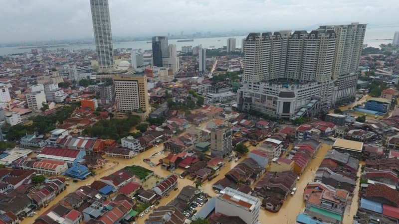
Flash floods caused by hours of torrential rain killed at least five people in Malaysia and the military deployed on Sunday to help rescue displaced people, Reuters reports. About 3,000 people had been evacuated and housed in temporary shelters as nearly 80 percent of Penang was hit by typhoon-like winds and heavy rain, its chief minister Lim Guan Eng said in a statement to Reuters. Floodwaters had reportedly risen 10 to 12 feet and Lim warned on Facebook that more rain was expected. Troops fanned out in Penang to rescue stranded flood victims and also to clear blocked routes and clean up. Hundreds of trees were toppled and roads were submerged in Penang’s historic capital of George Town, leaving many areas largely paralyzed. The Malaysian state news agency said five people had been killed due to the floods. “We remain fearful that there may still be untoward incidents because of the strong winds, the like of which have never been experienced before, and flash floods might recur,” Lim told reporters in Penang earlier on Sunday, according to Bernama.
Impact Statistic
5
Dead
0
Missing
0
Injured
9.5K
Affected Person
9.5K
Displaced
Human SADDD
- Dead 5
- Missing -
- Injured -
- Affected Person 9,543
- Affected Family 1,430
- Internaly Displaced People 9,543
- Refugees 0
- Evacuation Center (in Country) 92
- Evacuation Center (out Of Country) 0
House
- Affected Houses 0
- Damage Partial 0
- Totally Damage -
Infrastructure
- Bridges 0
- Number of Roads 0
- Road Distance (km) 0.00
Public
- Schools -
- Health -
- Government Office / Public Facilities 0
- Settlements 0
- Worship Places 0
- Others 0
General
Cost
- Local Currency 0.00
- Cost of Damages 0.00
- Cost of Damages (USD) -
- Cost of Assistance 0.00
- Cost of Assistance (USD) -
Agricultural
- Rice Field 0.00
- Other Crops 600.00
- Fish Ponds 3,500
- Cattle 0
- Poultries 0
- Livestock 0
Relevant Disasters
The ASEAN Disaster Information Network (ADINet) is a repository of information concerning hazards and disasters that have happened in the region. The platform is open for public, which means that the public can submit information about any hazard and disaster to the AHA Centre. Thereafter, the AHA Centre will verify and validate any submitted information to ensure the accuracy of the data inputs. The AHA Centre can also add new information when relevant and as necessary. ADINet has been recording disaster information in the region since the AHA Centre was operational in 2012.

Supported by :