Report Lists
Quick View
Sun, 14 Feb 2021
Indonesia, Flooding in Sragen Regency, Central Java Province
VERIFIED
CLOSED
AHA-FL-2021-000141-IDN
Quick View
Sun, 14 Feb 2021
Indonesia, Flooding and Landslide in Nganjuk Regency, East Java
VERIFIED
CLOSED
AHA-FL-2021-000142-IDN
Quick View
Sun, 14 Feb 2021
Philippines, Flooding in Negros Occidental
VERIFIED
CLOSED
AHA-FL-2021-000188-PHL
Quick View
Sat, 13 Feb 2021
Philippines, Flooding in General Santos City, Region XII
VERIFIED
CLOSED
AHA-FL-2021-000132-PHL
Quick View
Fri, 12 Feb 2021
Indonesia, Flooding in Bojonegoro Regency, East Java Province
VERIFIED
CLOSED
AHA-FL-2021-000133-IDN
Quick View
Thu, 11 Feb 2021
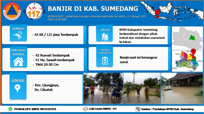
Indonesia, Flooding in Sumedang Regency, West Java
VERIFIED
CLOSED
AHA-FL-2021-000131-IDN
Quick View
Wed, 10 Feb 2021
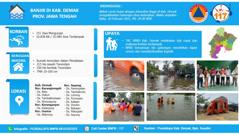
Indonesia, Flooding in Demak Regency, Central Java
VERIFIED
CLOSED
AHA-FL-2021-000124-IDN
Quick View
Wed, 10 Feb 2021
Indonesia, Flooding in Pati Regency, Central Java Province
VERIFIED
CLOSED
AHA-FL-2021-000135-IDN
Quick View
Tue, 09 Feb 2021
Indonesia, Flooding and Landslide in Kebumen Regency, Central Java
VERIFIED
CLOSED
AHA-LS-2021-000122-IDN
Quick View
Tue, 09 Feb 2021
Indonesia, Flooding in Region of Keerom. Papua
VERIFIED
CLOSED
AHA-FL-2021-000114-IDN
Quick View
Mon, 08 Feb 2021
Indonesia, Flooding in Serang Regency, Banten Province
VERIFIED
CLOSED
AHA-FL-2021-000136-IDN
Quick View
Mon, 08 Feb 2021
Indonesia, Flooding in Bogor District, West Java
VERIFIED
CLOSED
AHA-FL-2021-000117-IDN
Quick View
Mon, 08 Feb 2021
Indonesia, Flooding in District of Garut, West Java
VERIFIED
CLOSED
AHA-FL-2021-000115-IDN
Quick View
Mon, 08 Feb 2021
Indonesia, Flooding in Lombok Timur District, NTB Province
VERIFIED
CLOSED
AHA-FL-2021-000116-IDN
Quick View
Sun, 07 Feb 2021
Indonesia, Flooding and landslide in Majalengka, West Java
VERIFIED
CLOSED
AHA-FL-2021-000110-IDN
Quick View
Sun, 07 Feb 2021
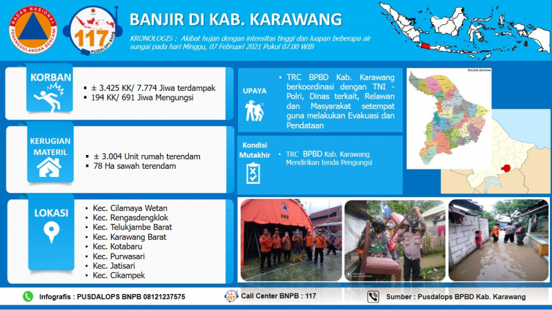
Indonesia, Flooding in Karawang, West Java
VERIFIED
CLOSED
AHA-FL-2021-000109-IDN
Quick View
Sun, 07 Feb 2021
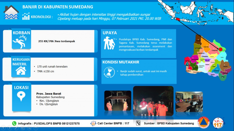
Indonesia, Flooding in Sumedang Regency, West Java Province
VERIFIED
CLOSED
AHA-FL-2021-000120-IDN
Quick View
Sun, 07 Feb 2021
Indonesia, Flooding in Indramayu Regency, West Java Province
VERIFIED
CLOSED
AHA-FL-2021-000121-IDN
Quick View
Sun, 07 Feb 2021
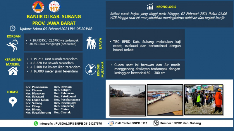
Indonesia, Flooding and landslide in Subang Regency, West Java
VERIFIED
CLOSED
AHA-FL-2021-000119-IDN
Quick View
Sun, 07 Feb 2021
Indonesia, Flooding in Jakarta, Indonesia
VERIFIED
CLOSED
AHA-FL-2021-000128-IDN