Indonesia, Flooding in Karawang, West Java
Feb 07, 2021 23:23
Sep 27, 2026 15:18
Location
Coordinate:
-6.3227, 107.3376
Administrative:
Jawa Barat, Indonesia
Affected Area:
Jawa Barat
Hazard
Main : Flood- Inundated Area (km) = fill value here
- Maximum Flood Depth (cm) = fill value here
Description
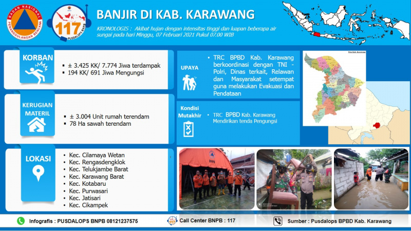
As of 12 Feb 2021. Due to high intensity rain since 7 Feb 2021 at 07.00 AM WIB, triggered 16 total sub districts are submerged (Cilamaya Wetan, Rengasdengklok, Teluk Jambe Barat, Kota Baru, Purwasari, Jatisari, Cikampek, Tirtamulya, Teluk Jambe Timur, Karwang Timur, Banyusari, Cilamaya Kulon, Batujaya, Cilebar, and Pakis Jaya) with water level 10 – 150 cm. The local BPBD with closely coordination with local police and military of Banjar, are continuing data collection, assessment, evacuating and logistic distribution to the affected people. Source: BPBD Karawang Mr. Supriatna through WA: 0857 2216 7671 and Pusdalop BPBD Province West Java Mr. Budi AB through WA 0821 2150 3467 Floods in the District. Karawang, Prov. West Java Update: Tuesday, February 9, 2021 Pkl. 08.00 WIB Chronology: • Due to high intensity rain and overflow of several rivers on Sunday, February 07, 2021 at 07.00 WIB Location: Kec. Cilamaya Wetan Kec. Rengasdenglok Kec. Telukjambe Barat Kec. Karawang Barat Kec. Kotabaru Kec. Jatisari Kec. Cikampek Kec. Tirtamulya Kec. Telukjambe Timur Kec. Karawang Timur Kec. Banyusari Kec. Cilamaya Kulon Kec. Batujaya Kec. Cilebar Kec. Pakisjaya Kec. Pangkalan Kec. Klari Fatalities : • 12,650 families / 37,474 people affected • 3,625 families / 8,648 people were displaced Material Disadvantages: • 11,044 housing units were submerged • ± 450 Ha of affected rice fields • 2 housing units (RB) • 9 housing units (RS) • 37 mosques were affected • 14 school units affected Effort : • TRC BPBD Kab. Karawang coordinates with the TNI - Polri, related services, volunteers and local communities to carry out evacuation and data collection Advanced Condition: • The weather is cloudy • Water still stagnates the affected area with a TMA 10 - 150 cm Source: • Secretary of the District BPBD. Karawang Bpk. Supriatna Informed by: PUSDALOPS BNPB Complaint / Call Center Number: 117 (Toll Free) Instagram: pusdalops_bnpb Twitter: @Bnpbpusdalops
Impact Statistic
0
Dead
0
Missing
1
Injured
44.8K
Affected Person
8.6K
Displaced
External Video
News
Human SADDD
- Dead -
- Missing -
- Injured 1
- Affected Person 44,846
- Affected Family 15,144
- Internaly Displaced People 8,648
- Refugees -
- Evacuation Center (in Country) -
- Evacuation Center (out Of Country) -
House
- Affected Houses 11,044
- Damage Partial 9
- Totally Damage 2
Infrastructure
- Bridges -
- Number of Roads -
- Road Distance (km) -
Public
- Schools 14
- Health -
- Government Office / Public Facilities -
- Settlements -
- Worship Places 37
- Others -
General
Cost
- Local Currency 0.00
- Cost of Damages -
- Cost of Damages (USD) -
- Cost of Assistance -
- Cost of Assistance (USD) -
Agricultural
- Rice Field 492.00
- Other Crops 38.00
- Fish Ponds -
- Cattle -
- Poultries -
- Livestock -
Relevant Disasters
The ASEAN Disaster Information Network (ADINet) is a repository of information concerning hazards and disasters that have happened in the region. The platform is open for public, which means that the public can submit information about any hazard and disaster to the AHA Centre. Thereafter, the AHA Centre will verify and validate any submitted information to ensure the accuracy of the data inputs. The AHA Centre can also add new information when relevant and as necessary. ADINet has been recording disaster information in the region since the AHA Centre was operational in 2012.

Supported by :