Thailand, Flooding in Phetchaburi
Nov 28, 2017 20:16
Sep 27, 2026 15:11
Location
Coordinate:
13.069287, 99.604438
Administrative:
Phetchaburi, Thailand
Affected Area:
Phetchaburi
Hazard
Main : Flood- Inundated Area (km) = fill value here
- Maximum Flood Depth (cm) = fill value here
Description
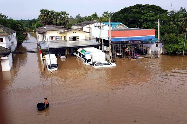
The Phetchaburi river has burst its banks. Floodwaters are causing significant damage and disruption. The waters inundated major towns and roads. People were wading thigh deep in Muang district on Thursday after heavy rain. Schools and government offices were flooded. The overflow spilled onto Phetkasem Road, causing a traffic jam for about four kilometres, with water up to 60 centimetres deep. The province advised people to move to high ground as water continued to flow from the river, which passes through Phetchaburi town centre. Phetchaburi governor Chatporn Ratdusadee said work crews were battling to drain the flood to the river downstream. They hope to end the crisis within the next three days. The Disaster Prevention and Mitigation Department reported floods in Ban Laem, Cha-am and Tha Yang districts of the province. Storm Kirogi has brought downpours to southern provinces since Wednesday night. There could be further disruptions, as the Meteorological Department warned of more rain and possible flash floods until next Tuesday.
Impact Statistic
0
Dead
0
Missing
0
Injured
0
Affected Person
0
Displaced
Human SADDD
- Dead -
- Missing -
- Injured -
- Affected Person -
- Affected Family -
- Internaly Displaced People -
- Refugees 0
- Evacuation Center (in Country) -
- Evacuation Center (out Of Country) 0
House
- Affected Houses 0
- Damage Partial 0
- Totally Damage -
Infrastructure
- Bridges 0
- Number of Roads 0
- Road Distance (km) 0.00
Public
- Schools -
- Health -
- Government Office / Public Facilities 0
- Settlements 0
- Worship Places 0
- Others 0
General
Cost
- Local Currency 0.00
- Cost of Damages 0.00
- Cost of Damages (USD) -
- Cost of Assistance 0.00
- Cost of Assistance (USD) -
Agricultural
- Rice Field 0.00
- Other Crops 0.00
- Fish Ponds 0
- Cattle 0
- Poultries 0
- Livestock 0
Relevant Disasters
The ASEAN Disaster Information Network (ADINet) is a repository of information concerning hazards and disasters that have happened in the region. The platform is open for public, which means that the public can submit information about any hazard and disaster to the AHA Centre. Thereafter, the AHA Centre will verify and validate any submitted information to ensure the accuracy of the data inputs. The AHA Centre can also add new information when relevant and as necessary. ADINet has been recording disaster information in the region since the AHA Centre was operational in 2012.

Supported by :