Thailand, Flood in 22 provinces of northern part
Aug 07, 2017 04:42
Sep 27, 2026 15:11
Location
Coordinate:
15.476511, 100.364198
Administrative:
Nakhon Sawan, Thailand
Affected Area:
Chiang Mai, Kalasin, Kamphaeng Phet, Uthai Thani, Khon Kaen, Loei, Ang Thong, Chai Nat, Lop Buri, Maha Sarakham, Phra Nakhon Si Ayutthaya, Roi Et, Pathum Thani, Nakhon Sawan, Nong Bua Lam Phu, Phichit, Phetchabun, Sing Buri, Sukhothai, Suphan Buri, Tak, Ubon Ratchathani
Hazard
Main : Flood- Inundated Area (km) = fill value here
- Maximum Flood Depth (cm) = fill value here
Description
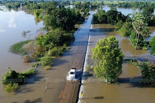
According to a statement made Thailand‘ Department of Disaster Prevention and Mitigation (DDPM), flashfloods, overflow and accelerated discharge by the Chao Phraya dam from 10 to 25 October 2017 has inundated 76 districts of 22 provinces in northern part of the country. The flooding claimed nine lives and affected 121,217 households in 2,673 villages. By 25 October 2017, the DPPM has coordinated provincial, local administrative and the military in assisting flood-stricken residents. Royal Irrigation Department also stated that the discharge rate at the Chao Phraya dam in Chai Nat Province was raised from 2,600 cu/m to 2,700 cu/m, and thus will not impact Bangkok. In addition, the situation has improved and flooding in Kamphaeng Phet, Loei and Phetchabun has eased.
Impact Statistic
9
Dead
0
Missing
0
Injured
606.1K
Affected Person
0
Displaced
Human SADDD
- Dead 9
- Missing -
- Injured -
- Affected Person 606,085
- Affected Family 121,217
- Internaly Displaced People -
- Refugees 0
- Evacuation Center (in Country) -
- Evacuation Center (out Of Country) 0
House
- Affected Houses 0
- Damage Partial 0
- Totally Damage -
Infrastructure
- Bridges 0
- Number of Roads 0
- Road Distance (km) 0.00
Public
- Schools -
- Health -
- Government Office / Public Facilities 0
- Settlements 0
- Worship Places 0
- Others 0
General
Cost
- Local Currency 0.00
- Cost of Damages 0.00
- Cost of Damages (USD) -
- Cost of Assistance 0.00
- Cost of Assistance (USD) -
Agricultural
- Rice Field 0.00
- Other Crops 0.00
- Fish Ponds 0
- Cattle 0
- Poultries 0
- Livestock 0
Relevant Disasters
The ASEAN Disaster Information Network (ADINet) is a repository of information concerning hazards and disasters that have happened in the region. The platform is open for public, which means that the public can submit information about any hazard and disaster to the AHA Centre. Thereafter, the AHA Centre will verify and validate any submitted information to ensure the accuracy of the data inputs. The AHA Centre can also add new information when relevant and as necessary. ADINet has been recording disaster information in the region since the AHA Centre was operational in 2012.

Supported by :