Philippines, Volcanic Eruption Mount Taal in Calabarzon
Jul 01, 2021 15:16
Sep 27, 2026 15:18
Location
Coordinate:
14.0113, 120.9977
Administrative:
Batangas, Philippines
Affected Area:
Cavite, Batangas
Hazard
Main : Volcano- Run Up = fill value here
- causses = fill value here
- Inundation Area (km2) = fill value here
- Maximum Inundation Distance (km) = fill value here
- Estimated Time of Arrival (Hour, Minutes, Seconds) = fill value here
Description
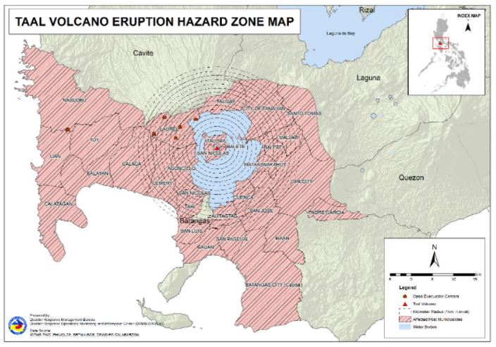
The Philippine Institute for Volcanology and Seismology (PHIVOLCS) has released an advisory indicating the raising of Taal Volcano's Alert Level from 2 (increasing unrest) to 3 (magmatic unrest). At 1216H UTC+7, Taal Volcano Main Crater generate a short-lived dark phreatomagmatic plume 1 kilometre-high with no accompanying volcanic earthquake.
The raising to Alert Level 3 signifies that there is magmatic intrusion at the Main Crater that may further drive succeeding eruptions.
PHIVOLCS strongly recommends Taal Volcano Island and high-risk barangays of Agoncillo and Laurel, Batangas to be evacuated due to the possible hazards of pyroclastic density currents and volcanic tsunami.
The public is reminded that the entire Volcano Island is a Permanent Danger Zone (PDZ) and entry to the island as well as into the high-risk barangays of Agoncillo and Laurel is prohibited. Communities around the Taal Lake shore are advised to take precautionary measures and to be vigilant of possible lakewater disturbances related to the ongoing unrest.
Impact Statistic
0
Dead
0
Missing
0
Injured
22.4K
Affected Person
22.4K
Displaced
Human SADDD
- Dead -
- Missing -
- Injured -
- Affected Person 22,433
- Affected Family 6,262
- Internaly Displaced People 22,433
- Refugees -
- Evacuation Center (in Country) 11
- Evacuation Center (out Of Country) -
House
- Affected Houses -
- Damage Partial -
- Totally Damage -
Infrastructure
- Bridges -
- Number of Roads -
- Road Distance (km) -
Public
- Schools -
- Health -
- Government Office / Public Facilities -
- Settlements -
- Worship Places -
- Others -
General
Cost
- Local Currency 0.00
- Cost of Damages 43,092,821.00
- Cost of Damages (USD) 785,000.00
- Cost of Assistance 16,419,300.00
- Cost of Assistance (USD) 326,938.00
Agricultural
- Rice Field -
- Other Crops -
- Fish Ponds -
- Cattle -
- Poultries -
- Livestock -
Relevant Disasters
The ASEAN Disaster Information Network (ADINet) is a repository of information concerning hazards and disasters that have happened in the region. The platform is open for public, which means that the public can submit information about any hazard and disaster to the AHA Centre. Thereafter, the AHA Centre will verify and validate any submitted information to ensure the accuracy of the data inputs. The AHA Centre can also add new information when relevant and as necessary. ADINet has been recording disaster information in the region since the AHA Centre was operational in 2012.

Supported by :