Malaysia, Flood in Terengganu
Nov 28, 2017 16:56
Sep 27, 2026 15:11
Location
Coordinate:
5.44273, 102.863588
Administrative:
Trengganu, Malaysia
Affected Area:
Trengganu
Hazard
Main : Flood- Inundated Area (km) = fill value here
- Maximum Flood Depth (cm) = fill value here
Description
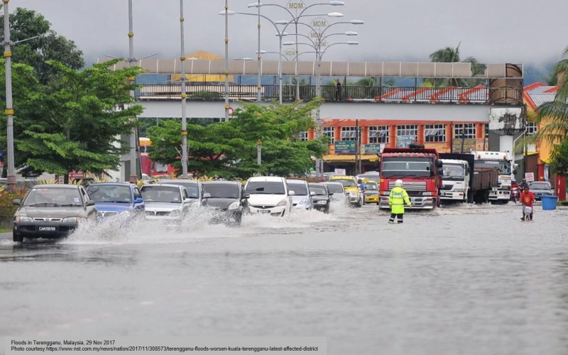
Update as of 9 December 2017 = National Disaster Management Agency of Malaysia (NADMA) reported all evacuation sites in Trengganu have closed and all affected people returned to original dwellings. = Update as of 8 December 2017 = National Disaster Management Agency of Malaysia (NADMA) reported 1 evacuation site in Trengganu still open, sheltering 212 IDPs from 51 families. = Update on 4 December 2017 Terengganu‘ Civil Defense Forces (LMD) director, Left Kol Che Adam A Rahman, said the weather was good and there was no rain today so many flood-hit areas began to recede, thereby allowing victims to return home. He said one PPS in Setiu had previously placed 32 victims from seven families completely closed at 9am this morning. Meanwhile, the publicinfobanjir.water.gov.my website showed that all major rivers in eight districts in the state recorded a normal level reading. = Update on 3 December 2017 = Malaysian government InfoBanjir platform reported number of evacuees have recorded at 1,479. = Update on 2 December 2017 = Data from State Civil Defence Department: 600 people from 169 families are taking shelter at 12 relief centres state-wide. In Marang, 368 people from 108 families are housed at four relief centres, namely Sekolah Menengah Kebangsaan (SMK) Seri Payong, Sekolah Kebangsaan (SK) Bukit Gasing, SK Marang and SK Pasir Putih. In Kuala Terengganu, 45 people from 15 families are at Sekolah Kebangsaan Chendering. In Kuala Nerus, 54 people from 14 families were evacuated to three relief centres, including SK Bukit Nenas and SK Bukit Guntong. In Dungun, 47 people from 12 families are at the Paka Civic Centre. In Setiu, two relief centres are accommodating 65 people from 14 families. In Besut, 21 victims from six families are at Sekolah Kebangsaan Tembila. According to the Department of Irrigation and Drainage, three rivers in Marang and Setiu are above their warning levels on 2 December 2017. Sungai Nerus in Kampung Langkap, Setiu, is at 21.44 metres (its warning level is 20.75m); while the reading at Sungai Chalok at the Chalok Bridge in Setiu is at 8.34 metres (its warning level is 7.70m). Sungai Marang at the Pengkalan Berangan bridge is at 2.31 metres (0.01 metre above the warning level). = 29 Nov 2017 = The flood situation in Terengganu has caused evacuation of 2,935 people from 959 families in seven districts in 74 relief centres, as of 29 November 2017, 09.32 local time. Due to the flooding, three rivers have exceeded their warning levels.The water level at Sungai Marang at the Pengkalan Berangan bridge now stands 2.49 metres, exceeding its warning level by 0.19 metres. Sungai Nerus in Kampung Langkap Setiu is now up to 21.39 metres, 0.64 metres above the safe level. Sungai Chalok now stands at 7.85 metres, which is 0.16 metres above its normal level of 7.70 metres.
Impact Statistic
0
Dead
0
Missing
0
Injured
2.9K
Affected Person
0
Displaced
Human SADDD
- Dead -
- Missing -
- Injured -
- Affected Person 2,935
- Affected Family 959
- Internaly Displaced People -
- Refugees 0
- Evacuation Center (in Country) 74
- Evacuation Center (out Of Country) 0
House
- Affected Houses 0
- Damage Partial 0
- Totally Damage -
Infrastructure
- Bridges 0
- Number of Roads 0
- Road Distance (km) 0.00
Public
- Schools -
- Health -
- Government Office / Public Facilities 0
- Settlements 0
- Worship Places 0
- Others 0
General
Cost
- Local Currency 0.00
- Cost of Damages 0.00
- Cost of Damages (USD) -
- Cost of Assistance 0.00
- Cost of Assistance (USD) -
Agricultural
- Rice Field 0.00
- Other Crops 0.00
- Fish Ponds 0
- Cattle 0
- Poultries 0
- Livestock 0
Relevant Disasters
The ASEAN Disaster Information Network (ADINet) is a repository of information concerning hazards and disasters that have happened in the region. The platform is open for public, which means that the public can submit information about any hazard and disaster to the AHA Centre. Thereafter, the AHA Centre will verify and validate any submitted information to ensure the accuracy of the data inputs. The AHA Centre can also add new information when relevant and as necessary. ADINet has been recording disaster information in the region since the AHA Centre was operational in 2012.

Supported by :