Indonesia, Landslide and floods in Bogor, Jakarta and Tangerang
Feb 08, 2018 18:07
Sep 27, 2026 15:11
Location
Coordinate:
-6.340832, 106.826987
Administrative:
Jakarta Raya, Indonesia
Affected Area:
Jakarta Raya
Hazard
Main : Flood- Inundated Area (km) = fill value here
- Maximum Flood Depth (cm) = fill value here
Description
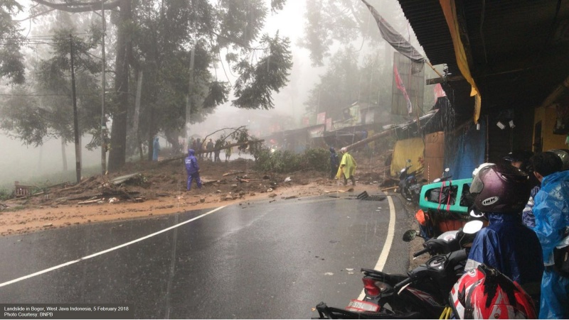
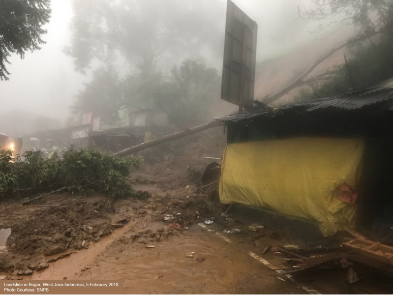
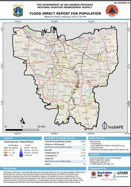
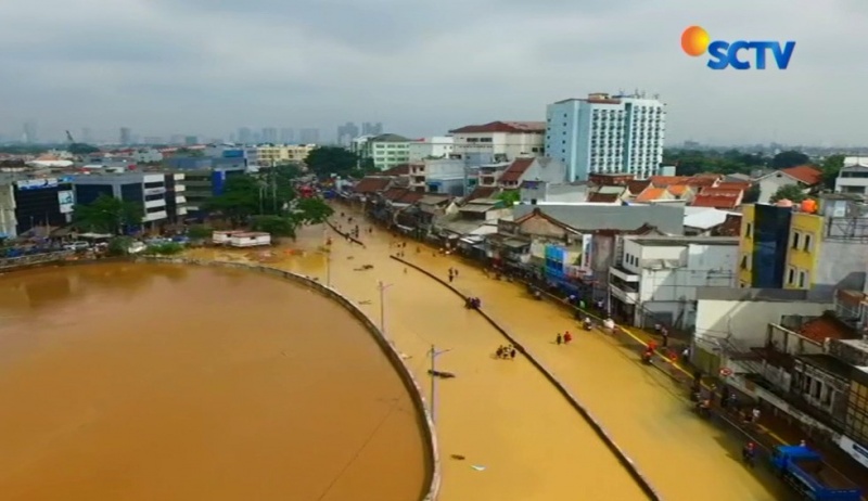
Update on 10 February 2018 = 1) Local Disaster Management Agency (BPBD) of Jakarta Region reported all inundation have been receded. 2) 1,100 people still displaced to 10 evacuation centers in East and South Jakarta. = Update on 6 February 2018 = 1) Local Disaster Management Agency (BPBD) of Jakarta Region reported 11450 people / 7228 families are affected in 20 sub-districts, 12 districts in East Jakarta and South Jakarta. 2) Around 6,532 people are evacuated to 31 evacuation centers in South Jakarta and East Jakarta. 3) Initial estimation suggests thousands of houses have been inundated 4) National Disaster Management Authority (BNPB) is supporting BPBD Jakarta and NGOs to assist the affected communities. = Report on 5 February 2018 = From 5 February 2018 09.05 UTC+8, Katulampa Dam has reached 240 cm and triggered Alert Level I (the highest for flood warning level). BNPB advised people in Ciliwung River watershed to be cautions of flooding and landslide risk. The heavy rainfall that started from 4 February 2018 and increased the water volume in Ciliwung River thus caused landslide and floods in several locations in Bogor Regency, Tangerang and Jakarta Capital Region, Indonesia. In Puncak Area of Bogor Regency, there were 4 landslide locations: Attawun, Widuri, Gran Hill and Riung Gunung. Landslide block the main access road between Jakarta and Puncak Area from 5 February 2018 morning. Local disaster management agency (BPBD) Bogor, Armed Forces of Indonesia, Police and Search and Rescue Agency (Basarnas) are on the ground for rescue operations. Regional traffic routes between Bogor and Jakarta are also affected. BPBD Bogor is also assessing the damage on the ground. It is reported that a 20 meters bridge in Mandey, Bogor regency, washed away. The water volume of Ciliwung River also overflow and caused flooding in several locations in East and South Jakarta. In Rawajati and Kampung Arus 2-2.5 meters of floods were reported as of 22.11 UTC+7. BPBD Jakarta Capital Region and other agencies are on alert, advising and assisting population at risk to be evacuated to evacuation centers prepared since the evening of Monday, 5 February 2018. Floods are predicted to inundate riverbanks around areas of Jakarta through which the river flows, such as Srengseng Sawah, Rawajati, Kalibata, Pengadegan, East Pejaten, Kebon Baru, Bukit Duri, Balekambang, Cililitan, Chinese Bidara and Kampung Melayu. BPBD Jakarta reported an estimated of 950 people have been dispaced and total affected population reached 94400. In Tangerang, heavy rainfall also caused a landslide in South perimeter of access road to Soekarno Hatta International Airport. Two persons were trapped in a car and managed to be evacuated after 14 hours rescue efforts by Basarnas. One person injured and the other confirmed dead during treatment after rescue efforts. BMKG stated extreme weather will continue for the next three days due to LPA in eastern part of Philippines and western part of Indian Ocean.
Impact Statistic
9
Dead
0
Missing
1
Injured
94.4K
Affected Person
6.5K
Displaced
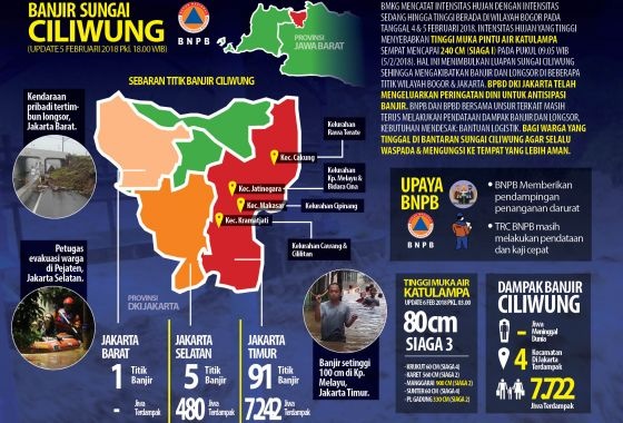
Human SADDD
- Dead 9
- Missing -
- Injured 1
- Affected Person 94,400
- Affected Family 18,880
- Internaly Displaced People 6,532
- Refugees 0
- Evacuation Center (in Country) 31
- Evacuation Center (out Of Country) 0
House
- Affected Houses 1,000
- Damage Partial 0
- Totally Damage -
Infrastructure
- Bridges 0
- Number of Roads 0
- Road Distance (km) 0.00
Public
- Schools -
- Health -
- Government Office / Public Facilities 0
- Settlements 0
- Worship Places 0
- Others 0
General
Cost
- Local Currency 0.00
- Cost of Damages 0.00
- Cost of Damages (USD) -
- Cost of Assistance 0.00
- Cost of Assistance (USD) -
Agricultural
- Rice Field 0.00
- Other Crops 0.00
- Fish Ponds 0
- Cattle 0
- Poultries 0
- Livestock 0
Relevant Disasters
The ASEAN Disaster Information Network (ADINet) is a repository of information concerning hazards and disasters that have happened in the region. The platform is open for public, which means that the public can submit information about any hazard and disaster to the AHA Centre. Thereafter, the AHA Centre will verify and validate any submitted information to ensure the accuracy of the data inputs. The AHA Centre can also add new information when relevant and as necessary. ADINet has been recording disaster information in the region since the AHA Centre was operational in 2012.

Supported by :