Indonesia, Floods in North Aceh
Dec 08, 2017 17:00
Sep 27, 2026 15:11
Location
Coordinate:
5.117274, 97.101258
Administrative:
Aceh, Indonesia
Affected Area:
Aceh
Hazard
Main : Flood- Inundated Area (km) = fill value here
- Maximum Flood Depth (cm) = fill value here
Description
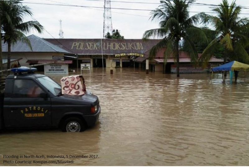
Update 5 December 2017 = North Aceh Regency local disaster management office (BPBD) stated until Tuesday 5 Dec 2017, flooding has occurred in 23 districts in the regency, with flood depth vary between 1 and 1.5 meters. The affected districts include Seunuddon, Lhoksukon, Matangkuli, Pirak Timu, Baktiya, Baktiya Barat, Tanah Jambo Aye, Tanah Luas, Nisam Antara, Muara Batu, Sawang, Langkahan, Samudera, Meurah Mulia, Syamtalira Aron, Lapang, Geureudong Pase, Simpang Keuramat, Syamtalira Bayu, Paya Bakong, Dewantara, Cot Girek and Banda Baro. The widespread of flooding areas were affected due to over-flow from 4 rivers namely Krueng Keureuto, Krueng Pase, Krueng Buloh and Krueng Tanah Jambo Aye rivers. In total, North Aceh regency BPBD reported the number of Internally Displaced People (IDPs) have reached 15,475 people, with the following available details: 1. Lhoksukon district, 8,586 IDPs, 17 evacuation sites. 2. Pirak Timu district, 3,287 IDPs, 12 evacuation sites. 3. Langkahan district, 510 IDPs, 4 evacuation sites. 4. Matangkuli district, 2,772 IDPs, 13 evacuation sites. 5. Seunuddon district, 29 IDPs, 1 evacuation site. 6. Baktiya Barat district, 227 IDPs, 3 evacuation sites. 7. Tanah Jambo Aye district, 138 IDPs, 1 evacuation site. 8. Baktiya district, 826 IDPs, 6 evacuation sites.
Impact Statistic
0
Dead
0
Missing
0
Injured
15.5K
Affected Person
15.5K
Displaced
Human SADDD
- Dead -
- Missing -
- Injured -
- Affected Person 15,475
- Affected Family 3,095
- Internaly Displaced People 15,475
- Refugees 0
- Evacuation Center (in Country) -
- Evacuation Center (out Of Country) 0
House
- Affected Houses 0
- Damage Partial 0
- Totally Damage -
Infrastructure
- Bridges 0
- Number of Roads 0
- Road Distance (km) 0.00
Public
- Schools -
- Health -
- Government Office / Public Facilities 0
- Settlements 0
- Worship Places 0
- Others 0
General
Cost
- Local Currency 0.00
- Cost of Damages 0.00
- Cost of Damages (USD) -
- Cost of Assistance 0.00
- Cost of Assistance (USD) -
Agricultural
- Rice Field 0.00
- Other Crops 0.00
- Fish Ponds 0
- Cattle 0
- Poultries 0
- Livestock 0
Relevant Disasters
The ASEAN Disaster Information Network (ADINet) is a repository of information concerning hazards and disasters that have happened in the region. The platform is open for public, which means that the public can submit information about any hazard and disaster to the AHA Centre. Thereafter, the AHA Centre will verify and validate any submitted information to ensure the accuracy of the data inputs. The AHA Centre can also add new information when relevant and as necessary. ADINet has been recording disaster information in the region since the AHA Centre was operational in 2012.

Supported by :