Indonesia, Floods and Landslides in Bungo (Jambi)
Feb 21, 2024 16:20
Feb 26, 2024 09:00
Location
Coordinate:
-1.5988859545764, 101.93100215258
Administrative:
Jambi, Indonesia
Affected Area:
Jambi
Hazard
Main : Flood- Inundated Area (km) = -
- Maximum Flood Depth (cm) = -
Description
998 / 5,000
Translation results
Translation result
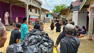
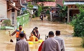
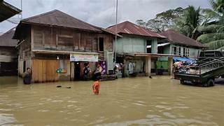
➢Chronology: high intensity rain on Wednesday, February 21 2024 at 16.20 WIB
➢Location:
Jujuhan Ilir District
●Betel Sekapur Village
●Ujung Tanjung Village
●Rantau Ikil Village, Rantau Pandan District
●Rantau Duku Village, Bathin Ulu III District
●Muara Buat Village, Muko-Muko Bathin III District
●Bedaro Village
●There were landslides at several points (in front of PT. Strarubber, shoulder of the road at the Mustafawiyah Islamic Boarding School)
●The decline of asphalt in Rantau Ikil Hamlet towards Panual, resulted in several spots of asphalt cracking.
●Road access from Rantau Pandan District can only be passed by large/tall cars
➢Efforts:
●The Bungo Regency Regional Disaster Management Agency coordinates with the local government and carries out an assessment
●The Bungo Regency Regional Disaster Management Agency coordinates with the Bungo Regency Public Housing Public Works Service and the State Electricity Company Service
➢Source: Mr. Akhyar, Head of Prevention and Emergency Division, Bungo Regency Regional Disaster Management Agency
Impact Statistic
0
Dead
0
Missing
0
Injured
738
Affected Person
0
Displaced
Human SADDD
- Dead -
- Missing -
- Injured -
- Affected Person 738
- Affected Family 234
- Internaly Displaced People -
- Refugees -
- Evacuation Center (in Country) -
- Evacuation Center (out Of Country) -
House
- Affected Houses 19
- Damage Partial 2
- Totally Damage 1
Infrastructure
- Bridges -
- Number of Roads -
- Road Distance (km) -
Public
- Schools -
- Health -
- Government Office / Public Facilities -
- Settlements -
- Worship Places -
- Others -
General
Cost
- Local Currency -
- Cost of Damages -
- Cost of Damages (USD) -
- Cost of Assistance -
- Cost of Assistance (USD) -
Agricultural
- Rice Field -
- Other Crops -
- Fish Ponds -
- Cattle -
- Poultries -
- Livestock -
Relevant Disasters
The ASEAN Disaster Information Network (ADINet) is a repository of information concerning hazards and disasters that have happened in the region. The platform is open for public, which means that the public can submit information about any hazard and disaster to the AHA Centre. Thereafter, the AHA Centre will verify and validate any submitted information to ensure the accuracy of the data inputs. The AHA Centre can also add new information when relevant and as necessary. ADINet has been recording disaster information in the region since the AHA Centre was operational in 2012.

Supported by :