Indonesia, Flooding in Tebing Tinggi (North Sumatra)
Oct 09, 2024 02:00
Oct 13, 2024 06:00
Location
Coordinate:
3.3283609193392, 99.155708899707
Administrative:
Sumatera Utara, Indonesia
Affected Area:
Sumatera Utara
Hazard
Main : Flood- Inundated Area (km) = -
- Maximum Flood Depth (cm) = -
Description
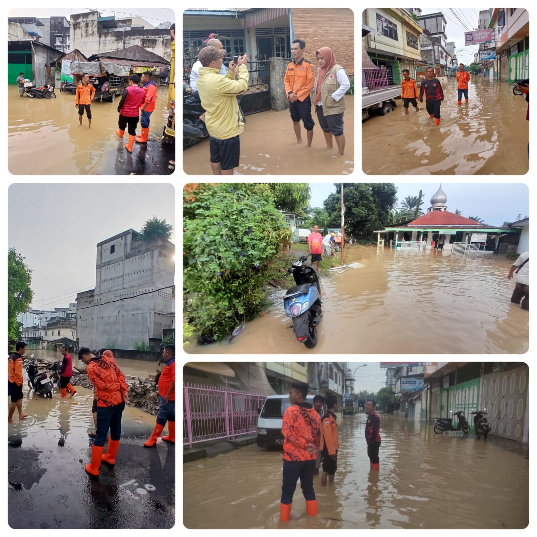
➢ Chronology: Triggered by flood in Tebing Tinggi City, North Sumatra Province due to very high rainfall intensity from the upstream of the Padang River, namely Simalungun Regency 113.2 mm and Serdang Bedagai Regency (Sipispis 7.6 mm) and high rainfall in Tebing Tinggi City resulting in the overflow of the Padang River, Bahilang River, Sibarau River and Sei Kelembah River in Tebing Tinggi City at around 02.00 WIB on October 9, 2024. Wednesday, October 9, 2024 PKl. 02.00 WIB
➢ Location:
● Rambutan District
- Sri Padang Village
- Neighborhood I
- Neighborhood II
- Neighborhood III
- Neighborhood V
- Lalang Village
- Neighborhood IV
- Karya Jaya Village
- Neighborhood II
● Tebing Tinggi Kota District
- Tebing Tinggi Lama Village
- Neighborhood III
- Badak Bejuang Village
- Neighborhood IV
- Neighborhood VI
- Neighborhood VII
- Bandar Utama Village
- Neighborhood I
- Neighborhood III
● Bajenis District
- Brohol Village
- Neighborhood II
- Bandar Sakti Village
- Neighborhood III
- Neighborhood IV
- Neighborhood V
- Bulian Village
- Neighborhood II
- Neighborhood III
- Neighborhood IV
- Neighborhood VI
- Teluk Karang Village
- Neighborhood I
- Neighborhood II
- Pinang Mancung Village
- Neighborhood I
● Padang Hulu District
- Tualang Village
- Environment VI
- Pabatu Village
- Environment I
- Environment II
- Environment III
- Persiakan Village
- Environment II
● Hilir District
- Tambangan Hulu Village
- Environment I
- Environment II
➢ Casualties:
● 1,388 families / 4,465 people affected (data collection)
with details:
● Rambutan District
Sri Padang Village
- Area I 50 families / 200 people
- Area II 45 families / 120 people
- Area III 45 families / 120 people
- Area V 50 families / 130 people
Lalang Village
- Area IV 33 families / 85 people
Karya Jaya Village
- Area II 9 families / 38 people
● Tebing Tinggi Kota District
Tebing Tinggi Lama Village
- Level III 17 families / 55 people
Badak Bejuang Village
- Level IV, VI, VII 139 families / 389 people
Bandar Utama Village
- Level I 200 families / 580 people
- Level III 150 families / 580 people
● Bajenis District
Brohol Village
- Level II 135 families / 285 people
Bandar Sakti Village
- Level VI 20 families / 120 people
- Level V 6 families / 24 people
- Level III 19 families / 116 people
Bulian Village
- Level II 30 families / 116 people
- Level III 123 families / 486 people - Lk. IV 71 families / 183 people - Lk. VI 44 families / 155 people Teluk Karang Village - Lk. I, II 15 families / 45 people Pinang Mancung Village - Lk. I 4 families / 13 people - Jl. Gelatik 20 families / 86 people ● Padang Hulu District, Tualang Village - Lk. VI 35 families / 112 people Pabatu Village - Lk. I 9 families / 36 people - Lk. II 40 families / 175 people - Lk. III 9 families / 36 people Persikan Village - Lk. II 20 families / 80 people ● Hilir District, Tambangan Hulu Village - Lk. I, II 50 families / 100 people
➢ Material Losses:
● 1,171 houses affected (data collection)
- with details:
● Rambutan District
Sri Padang Village
- Level I 40 houses
- Level II 35 houses
- Level III 45 houses
- Level V 50 houses
- WATER LEVEL: 30-60 cm
Lalang Village
- Level IV 20 houses
- WATER LEVEL: 20-30 cm
Karya Jaya Village
- Level II 9 houses
● Tebing Tinggi Kota District
Tebing Tinggi Lama Village
- Level III 17 houses
- WATER LEVEL: ± 1 meter
Badak Bejuang Village
- Level IV, VI, VII 98 houses
- WATER LEVEL: ± 1 meter
Bandar Utama Village
- Level I 200 houses
- Level III 120 houses
- WATER LEVEL: ± 30 - 50 cm
● Bajenis District
Brohol Village
- Level II 75 houses
- WATER LEVEL: ± 20 - 40 cm
Bandar Sakti Village
- Level VI 20 houses
- Level V 6 houses
- Level III 19 houses
Bulian Village
- Level II 29 houses
- Level III 116 houses
- Level IV 65 houses
- Level VI 42 houses
Teluk Karang Village
- Level I, II 15 housing units
Pinang Mancung Village
- Lk. I 4 housing units
- Jl. Gelatik 20 housing units
● Padang Hulu District
Tualang Village
- Lk. VI 31 housing units
Pabatu Village
- Lk. I 9 housing units
- Lk. II 40 housing units
- Lk. III 9 housing units
Persakan Village
- Lk. II 20 housing units
● Hilir District
Tambangan Hulu Village
- Lk. I, II 17 housing units
- WATER LEVEL: ± 1 meter
➢ Efforts:
● Coordination with the Sub-district Head, Village Head, Head of Environment, OPD and related agencies,
● Coordinating with BBWS II through the PDA in the Padang River flow area to find out the condition and increase in the Padang River water discharge from the upstream area to the downstream area of the Padang River (Bajayu Dam).
● Coordinating with the Padang River PDA and the Bajayu Dam gate operator coordinator
● Coordinating with the Serdang Bedagai Regency BPBD
● Monitoring information from BMKG regarding the Weather Report received periodically.
● Some BPBD personnel are checking the river water discharge
● BPBD personnel are on standby at the Tebing Tinggi City BPBD office.
➢ Current Conditions:
● River water conditions are still stable
● Current weather conditions are cloudy in the Tebing Tinggi City area
Source: Mr. Iman Silaban, Head of Emergency and Logistics for Tebing Tinggi City
Impact Statistic
0
Dead
1
Missing
0
Injured
10.6K
Affected Person
0
Displaced
External Video
News
Human SADDD
- Dead -
- Missing 1
- Injured -
- Affected Person 10,586
- Affected Family 3,227
- Internaly Displaced People -
- Refugees -
- Evacuation Center (in Country) -
- Evacuation Center (out Of Country) -
House
- Affected Houses 2,921
- Damage Partial -
- Totally Damage -
Infrastructure
- Bridges -
- Number of Roads -
- Road Distance (km) -
Public
- Schools -
- Health -
- Government Office / Public Facilities -
- Settlements -
- Worship Places -
- Others -
General
Cost
- Local Currency -
- Cost of Damages -
- Cost of Damages (USD) -
- Cost of Assistance -
- Cost of Assistance (USD) -
Agricultural
- Rice Field -
- Other Crops -
- Fish Ponds -
- Cattle -
- Poultries -
- Livestock -
Relevant Disasters
The ASEAN Disaster Information Network (ADINet) is a repository of information concerning hazards and disasters that have happened in the region. The platform is open for public, which means that the public can submit information about any hazard and disaster to the AHA Centre. Thereafter, the AHA Centre will verify and validate any submitted information to ensure the accuracy of the data inputs. The AHA Centre can also add new information when relevant and as necessary. ADINet has been recording disaster information in the region since the AHA Centre was operational in 2012.

Supported by :