Indonesia, Flooding in Sumedang (West Java)
Feb 11, 2024 16:00
Feb 12, 2024 08:53
Location
Coordinate:
-6.825065808638, 107.98084992982
Administrative:
Jawa Barat, Indonesia
Affected Area:
Jawa Barat
Hazard
Main : Flood- Inundated Area (km) = -
- Maximum Flood Depth (cm) = -
Description
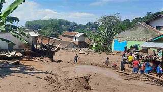
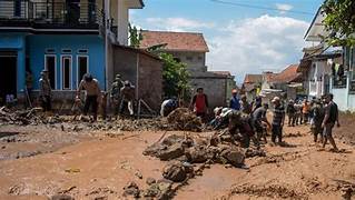
➢Chronology: triggered by heavy rain with a fairly long duration in the Ujungjaya District area. so that the Cipelang River experienced a high increase in water discharge, resulting in the Cipelang river embankment breaking, on Sunday, February 11 2024, at 16.00 WIB
➢Location:
●Ujung Jaya District
-Ujung Jaya Village
➢Casualty:
●220 Heads of Families / 700 people affected (Data Collection)
●1 Person Died (Mrs. Arum 73 years old) was declared Dead after being evacuated to the Ujung Jaya Health Center due to Hypothermia
➢Material Losses:
●± 220 housing units affected (Data Collection)
●Water level ± 50 - 300 cm
➢Efforts:
●The Regional Disaster Management Agency of Sumedang Regency carried out an assessment of the flood location to evacuate residents trapped in the flood as well as to record home owners.
●Regional Disaster Management Agency Together with TNI, Polri, Satpol PP, PMI, TAGANA and Volunteers evacuated residents and evacuated them to a safe place
●The Sumedang Regency Regional Disaster Management Agency has alerted 2 refugee tents.
●The Sumedang Regency Regional Disaster Management Agency appeals to residents to always be alert and careful about the current rainy season weather.
➢Latest Condition:
●The flood is gradually receding
●Regional Disaster Management Agency together with TNI, POLRI, TAGANA, PMI, and volunteers are still evacuating affected residents to safe places
➢Urgent Needs:
●Cleaning equipment, basic necessities and ready-to-eat logistics.
➢Source: Sumedang Regency Regional Disaster Management Agency Pusdalops
Impact Statistic
1
Dead
0
Missing
0
Injured
700
Affected Person
0
Displaced
External Video
News
Human SADDD
- Dead 1
- Missing -
- Injured -
- Affected Person 700
- Affected Family 220
- Internaly Displaced People -
- Refugees -
- Evacuation Center (in Country) -
- Evacuation Center (out Of Country) -
House
- Affected Houses 220
- Damage Partial -
- Totally Damage -
Infrastructure
- Bridges -
- Number of Roads -
- Road Distance (km) -
Public
- Schools -
- Health -
- Government Office / Public Facilities -
- Settlements -
- Worship Places -
- Others -
General
Cost
- Local Currency -
- Cost of Damages -
- Cost of Damages (USD) -
- Cost of Assistance -
- Cost of Assistance (USD) -
Agricultural
- Rice Field -
- Other Crops -
- Fish Ponds -
- Cattle -
- Poultries -
- Livestock -
Relevant Disasters
The ASEAN Disaster Information Network (ADINet) is a repository of information concerning hazards and disasters that have happened in the region. The platform is open for public, which means that the public can submit information about any hazard and disaster to the AHA Centre. Thereafter, the AHA Centre will verify and validate any submitted information to ensure the accuracy of the data inputs. The AHA Centre can also add new information when relevant and as necessary. ADINet has been recording disaster information in the region since the AHA Centre was operational in 2012.

Supported by :