Indonesia, Flooding in Solok, West Sumatera
Jan 11, 2021 23:30
Sep 27, 2026 15:18
Location
Coordinate:
-0.787336, 100.623192
Administrative:
Sumatera Barat, Indonesia
Affected Area:
Sumatera Barat
Hazard
Main : Flood- Inundated Area (km) = fill value here
- Maximum Flood Depth (cm) = fill value here
Description
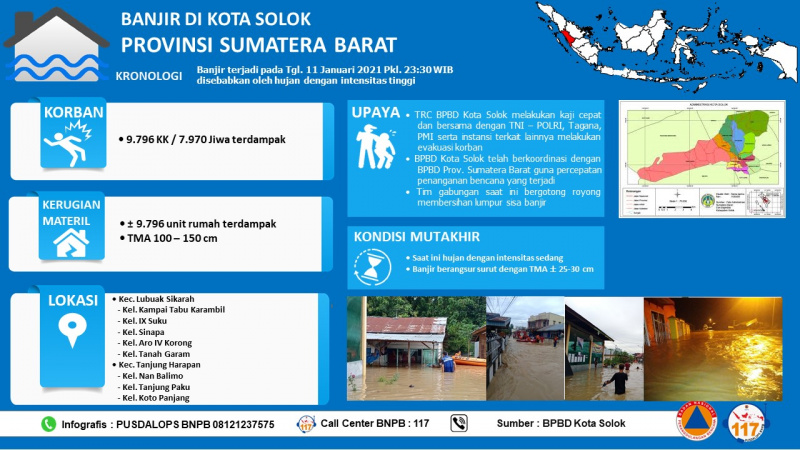
High rainfall intensity caused flooding in Solok, West Sumatera on 11 January 2021 2330 local time (GMT+7). Affected Locations: • Lubuak Sikarah Sub-region, - Kampai Tabu Karambil Village , - IX Suku Village - Sinapa Village, - Kel. Aro IV Korong Village, - Kel. Tanah Garam Village. • Kec. Tanjung Harapan Sub-region: - Kel. Nan Balimo Village , - Kel. Tanjung Paku Village, - Kel. Koto Panjang Village. Affected populations: • 7.970 people • Some of them are being evacuated Damage/Loss: • ± 9.796 houses submerged within 100 - 150 cm of water level Latest update: • Rain is still moderately pouring. • The flood has gradually receded (Water level 25-30 cm ) Immediate needs: • Clothes • Food • Tarpaulins • Mattress • Blanket • Tool kit Sumber : • Bpk. Ari Staff BPBD Kota Solok • Pusdalops BPBD Prov. Sumatera Barat Diinformasikan Oleh : PUSDALOPS-PB BNPB Nomor Pengaduan / Call Center : 117 (Bebas Pulsa) Instagram : pusdalops_bnpb Twitter : @Bnpbpusdalops
Impact Statistic
0
Dead
0
Missing
0
Injured
8K
Affected Person
8K
Displaced
Human SADDD
- Dead -
- Missing -
- Injured -
- Affected Person 7,970
- Affected Family 1,594
- Internaly Displaced People 7,970
- Refugees -
- Evacuation Center (in Country) -
- Evacuation Center (out Of Country) -
House
- Affected Houses 9,796
- Damage Partial -
- Totally Damage -
Infrastructure
- Bridges -
- Number of Roads -
- Road Distance (km) -
Public
- Schools -
- Health -
- Government Office / Public Facilities -
- Settlements -
- Worship Places -
- Others -
General
Cost
- Local Currency 0.00
- Cost of Damages -
- Cost of Damages (USD) -
- Cost of Assistance -
- Cost of Assistance (USD) -
Agricultural
- Rice Field -
- Other Crops -
- Fish Ponds -
- Cattle -
- Poultries -
- Livestock -
Relevant Disasters
The ASEAN Disaster Information Network (ADINet) is a repository of information concerning hazards and disasters that have happened in the region. The platform is open for public, which means that the public can submit information about any hazard and disaster to the AHA Centre. Thereafter, the AHA Centre will verify and validate any submitted information to ensure the accuracy of the data inputs. The AHA Centre can also add new information when relevant and as necessary. ADINet has been recording disaster information in the region since the AHA Centre was operational in 2012.

Supported by :