Indonesia, Flooding in Pekanbaru City, Riau Province
Mar 27, 2021 20:52
Sep 27, 2026 15:18
Location
Coordinate:
0.54988996161056, 101.46443646792
Administrative:
Riau, Indonesia
Affected Area:
Riau
Hazard
Main : Flood- Inundated Area (km) = fill value here
- Maximum Flood Depth (cm) = fill value here
Description
Chronology:
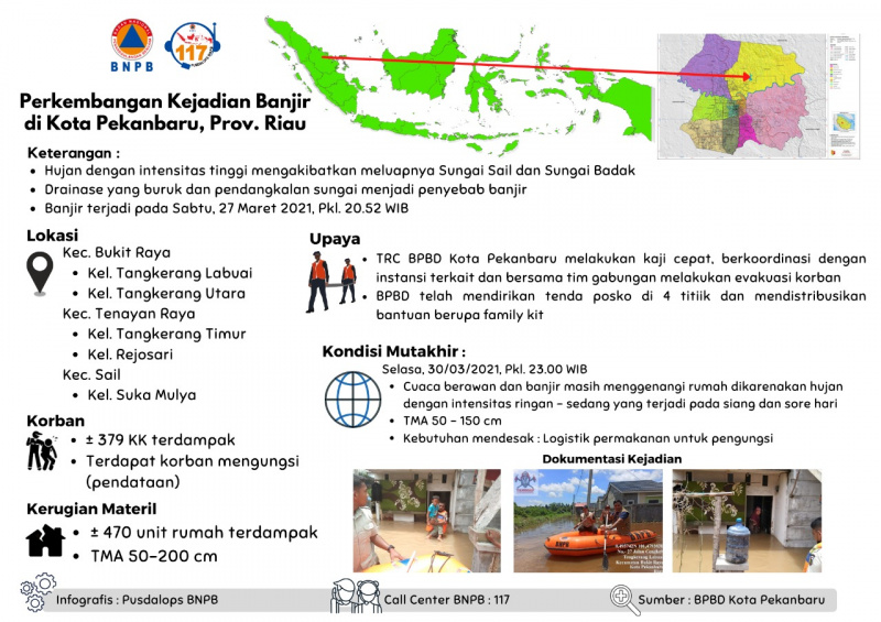
• High intensity rain caused the overflow of the Sail River and Badak River
• Poor drainage and river silting are the causes of flooding
• Floods occurred on Saturday, 27 March 2021, at 20.52 WIB
Location:
Bukit Raya Sub-district
• Tangkerang Labuai Village
• North Tangkerang Village
Tenayan Raya Sub-district
• East Tangkerang Village
• Rejosari Village
Sail Sub-district
• Suka Mulya Village
Affecting:
• ± 379 families
• There are victims displaced (data collection)
Material Disadvantages:
• ± 470 housing units were affected
• Flood depth 50-200 cm
Effort :
• Quick Response Team BPBD Pekanbaru City conducted a rapid assessment, coordinated with relevant agencies and together with the joint team carried out the evacuation of victims
• BPBD has set up post tents at 4 points and distributed aid in the form of family kits
Update:
Tuesday, 30/03/2021, at 23.00 WIB
• Cloudy weather and floods still inundate the house due to light to moderate rain that occurs during the day and evening
• Flood Depth 50 - 150 cm
Urgent needs:
• Food logistics for refugees
• Limited BPBD facilities and infrastructure
Source:
BPBD Pekanbaru City
• High intensity rain caused the overflow of the Sail River and Badak River
• Poor drainage and river silting are the causes of flooding
• Floods occurred on Saturday, 27 March 2021, at 20.52 WIB
Location:
Bukit Raya Sub-district
• Tangkerang Labuai Village
• North Tangkerang Village
Tenayan Raya Sub-district
• East Tangkerang Village
• Rejosari Village
Sail Sub-district
• Suka Mulya Village
Affecting:
• ± 379 families
• There are victims displaced (data collection)
Material Disadvantages:
• ± 470 housing units were affected
• Flood depth 50-200 cm
Effort :
• Quick Response Team BPBD Pekanbaru City conducted a rapid assessment, coordinated with relevant agencies and together with the joint team carried out the evacuation of victims
• BPBD has set up post tents at 4 points and distributed aid in the form of family kits
Update:
Tuesday, 30/03/2021, at 23.00 WIB
• Cloudy weather and floods still inundate the house due to light to moderate rain that occurs during the day and evening
• Flood Depth 50 - 150 cm
Urgent needs:
• Food logistics for refugees
• Limited BPBD facilities and infrastructure
Source:
BPBD Pekanbaru City
Impact Statistic
0
Dead
0
Missing
0
Injured
1.9K
Affected Person
0
Displaced
External Video
News
Human SADDD
- Dead -
- Missing -
- Injured -
- Affected Person 1,895
- Affected Family 379
- Internaly Displaced People -
- Refugees -
- Evacuation Center (in Country) -
- Evacuation Center (out Of Country) -
House
- Affected Houses 470
- Damage Partial -
- Totally Damage -
Infrastructure
- Bridges -
- Number of Roads -
- Road Distance (km) -
Public
- Schools -
- Health -
- Government Office / Public Facilities -
- Settlements -
- Worship Places -
- Others -
General
Cost
- Local Currency 0.00
- Cost of Damages -
- Cost of Damages (USD) -
- Cost of Assistance -
- Cost of Assistance (USD) -
Agricultural
- Rice Field -
- Other Crops -
- Fish Ponds -
- Cattle -
- Poultries -
- Livestock -
Relevant Disasters
The ASEAN Disaster Information Network (ADINet) is a repository of information concerning hazards and disasters that have happened in the region. The platform is open for public, which means that the public can submit information about any hazard and disaster to the AHA Centre. Thereafter, the AHA Centre will verify and validate any submitted information to ensure the accuracy of the data inputs. The AHA Centre can also add new information when relevant and as necessary. ADINet has been recording disaster information in the region since the AHA Centre was operational in 2012.

Supported by :