Indonesia, Flooding in Padang Lawas, North Sumatera Province
Mar 27, 2021 11:13
Sep 27, 2026 15:18
Location
Coordinate:
1.1410103209623, 99.842874444917
Administrative:
Sumatera Utara, Indonesia
Affected Area:
Sumatera Utara
Hazard
Main : Flood- Inundated Area (km) = fill value here
- Maximum Flood Depth (cm) = fill value here
Description
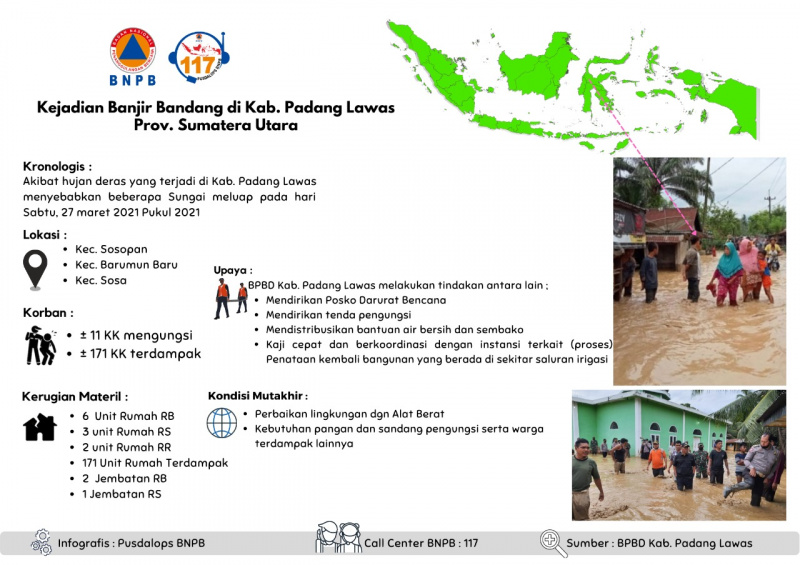
Flash floods in Padang Lawas District, North Sumatra Province
Chronology:
• Due to heavy rain that occurred in the District. Padang Lawas caused several rivers to overflow on Saturday, 27 March 2021 at 20.21 WIB
Location:
Sub-District: Sosopan, Barumun Baru, Sosa
Fatalities :
• ± 11 families were displaced
• ± 171 HHs affected
Material Disadvantages:
• 6 housing units heavily damaged
• 3 Hospital units
• 2 units of RR Houses
• 171 Affected Housing Units
• 2 Bridges heavily damaged
• 1 Bridge slightly damaged
Effort :
BPBD Padang Lawas District performs the following actions:
• Establishing a Disaster Emergency Post
• Establishing refugee tents
• Distributing clean water and basic necessities
• Quick assessment and coordination with related agencies (process) Rearrangement of buildings around the irrigation canals
Source:
• Mr. Sitorus Kasi RR BPBD Padang Lawas District
Informed by:
PUSDALOPS BNPB
Call Center / Complaint Number: 117 (Toll-Free)
Instagram: pusdalops_bnpb
Twitter: @Bnpbpusdalops
Chronology:
• Due to heavy rain that occurred in the District. Padang Lawas caused several rivers to overflow on Saturday, 27 March 2021 at 20.21 WIB
Location:
Sub-District: Sosopan, Barumun Baru, Sosa
Fatalities :
• ± 11 families were displaced
• ± 171 HHs affected
Material Disadvantages:
• 6 housing units heavily damaged
• 3 Hospital units
• 2 units of RR Houses
• 171 Affected Housing Units
• 2 Bridges heavily damaged
• 1 Bridge slightly damaged
Effort :
BPBD Padang Lawas District performs the following actions:
• Establishing a Disaster Emergency Post
• Establishing refugee tents
• Distributing clean water and basic necessities
• Quick assessment and coordination with related agencies (process) Rearrangement of buildings around the irrigation canals
Source:
• Mr. Sitorus Kasi RR BPBD Padang Lawas District
Informed by:
PUSDALOPS BNPB
Call Center / Complaint Number: 117 (Toll-Free)
Instagram: pusdalops_bnpb
Twitter: @Bnpbpusdalops
Impact Statistic
0
Dead
0
Missing
0
Injured
855
Affected Person
55
Displaced
External Video
News
Human SADDD
- Dead -
- Missing -
- Injured -
- Affected Person 855
- Affected Family 171
- Internaly Displaced People 55
- Refugees -
- Evacuation Center (in Country) -
- Evacuation Center (out Of Country) -
House
- Affected Houses 171
- Damage Partial 2
- Totally Damage 6
Infrastructure
- Bridges 3
- Number of Roads 3
- Road Distance (km) -
Public
- Schools -
- Health 3
- Government Office / Public Facilities -
- Settlements -
- Worship Places -
- Others -
General
Cost
- Local Currency 0.00
- Cost of Damages -
- Cost of Damages (USD) -
- Cost of Assistance -
- Cost of Assistance (USD) -
Agricultural
- Rice Field -
- Other Crops -
- Fish Ponds -
- Cattle -
- Poultries -
- Livestock -
Relevant Disasters
The ASEAN Disaster Information Network (ADINet) is a repository of information concerning hazards and disasters that have happened in the region. The platform is open for public, which means that the public can submit information about any hazard and disaster to the AHA Centre. Thereafter, the AHA Centre will verify and validate any submitted information to ensure the accuracy of the data inputs. The AHA Centre can also add new information when relevant and as necessary. ADINet has been recording disaster information in the region since the AHA Centre was operational in 2012.

Supported by :