Indonesia, Flooding in Makassar, South Sulawesi
Dec 18, 2020 13:53
Sep 27, 2026 15:18
Location
Coordinate:
-5.148758, 119.452406
Administrative:
Jawa Tengah, Indonesia
Affected Area:
Sulawesi Selatan
Hazard
Main : Flood- Inundated Area (km) = fill value here
- Maximum Flood Depth (cm) = fill value here
Description
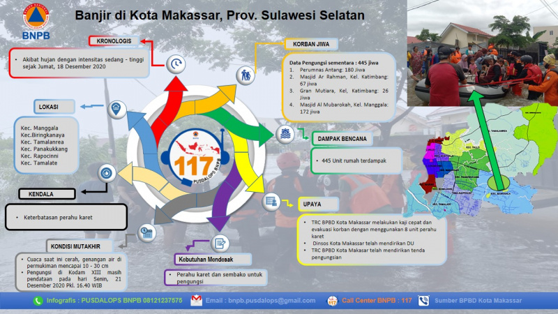
Causes: Due to moderate to high-intensity rain since Friday, 18 October 2020 Location: Manggala District, Kec. Biringkanaya, Kec. Tamalanrea, Kec. Panakukkang, Kec. Rapocinni Kec. Tamalate. Impact (Temporary data): Total Refugees: 445 persons 1. Perumnas Antang: 180 persons 2. Ar Rahman Mosque, Draw Village: 67 persons 3. Gran Mutiara, Ex, Katimbang: 26 persons 4. Masjid Al Mubarokah, Kel. Manggala: 172 persons Assistance: - Makassar City BPBD TRC conducted a quick assessment and evacuation of victims using 7 rubber boats - The Office of Social Department of Makassar has established the public kitchen for the refugees - Makassar City BPBD quick response team has set up evacuation tents Advanced Condition: - The weather is sunny, standing water in the settlement has reached 10-30 cm - Refugees at Kodam III are still collecting data as of 21 Dec 2020 at 4.40 PM Source: Mr. Rusly Kalak BPBD Makassar City Informed by: PUSDALOPS-PB BNPB Complaint / Call Center Number: 117 (Toll Free) Instagram: pusdalops_bnpb Twitter: @Bnpbpusdalops
Impact Statistic
0
Dead
0
Missing
0
Injured
445
Affected Person
445
Displaced
Human SADDD
- Dead -
- Missing -
- Injured -
- Affected Person 445
- Affected Family 89
- Internaly Displaced People 445
- Refugees -
- Evacuation Center (in Country) -
- Evacuation Center (out Of Country) -
House
- Affected Houses 445
- Damage Partial -
- Totally Damage -
Infrastructure
- Bridges -
- Number of Roads -
- Road Distance (km) -
Public
- Schools -
- Health -
- Government Office / Public Facilities -
- Settlements -
- Worship Places -
- Others -
General
Cost
- Local Currency 0.00
- Cost of Damages -
- Cost of Damages (USD) -
- Cost of Assistance -
- Cost of Assistance (USD) -
Agricultural
- Rice Field -
- Other Crops -
- Fish Ponds -
- Cattle -
- Poultries -
- Livestock -
Relevant Disasters
The ASEAN Disaster Information Network (ADINet) is a repository of information concerning hazards and disasters that have happened in the region. The platform is open for public, which means that the public can submit information about any hazard and disaster to the AHA Centre. Thereafter, the AHA Centre will verify and validate any submitted information to ensure the accuracy of the data inputs. The AHA Centre can also add new information when relevant and as necessary. ADINet has been recording disaster information in the region since the AHA Centre was operational in 2012.

Supported by :