Indonesia, Flooding in Lima Puluh Kota Regency, West Sumatra
Mar 13, 2021 16:00
Sep 27, 2026 15:18
Location
Coordinate:
0.033908, 100.526964
Administrative:
Sumatera Barat, Indonesia
Affected Area:
Sumatera Barat
Hazard
Main : Flood- Inundated Area (km) = fill value here
- Maximum Flood Depth (cm) = fill value here
Description
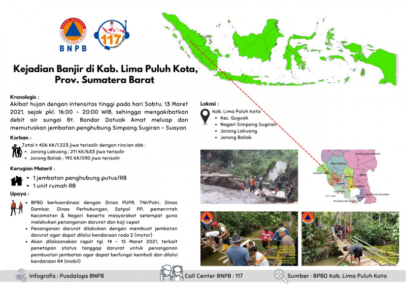
Chronology: • Due to high-intensity rain on Saturday, March 13, 2021, since 11 am. 16:00 - 20:00 WIB, resulting in river water discharge Bt. Bondar Datuak Amat overflowed and cut off the connecting bridge for the Sugiran - Suayan intersection Location: • Kec. Guguak • Nagari Simpang Sugiran Fatalities : A total of ± 406 families / 1,223 people are isolated, with the following details: • Jorong Lakuang; 211 KK / 633 people are isolated • Jorong Baliak; 195 KK / 590 people are isolated Material Disadvantages: • 1 bridge connecting break • 1 unit of house Effort : • BPBD coordinates with the PUPR Office, TNI / Polri, Damkar Service, Transportation Service, Satpol PP, District & Nagari governments and the local community to carry out emergency handling and rapid assessments • Emergency handling is carried out by constructing an emergency bridge so that it can be passed by 2-wheeled vehicles (motorbikes) • There will be a meeting on the date. March 14 - 15, 2021 regarding the determination of the emergency response status for handling the construction of a bridge so that it can function again and be traversed by 4 wheels vehicles (cars) Latest condition: • Residents living in 2 Jorong who were once isolated are now no longer isolated, because emergency handling has been carried out by building an emergency connecting bridge that can only be passed by R2 (motorbike) Source: BPBD Kab. Lima Puluh Kota Informed by: PUSDALOPS-PB BNPB Call Center / Complaint Number: 117 (Toll Free) Instagram: pusdalops_bnpb Twitter: @Bnpbpusdalops
Impact Statistic
0
Dead
0
Missing
0
Injured
1.2K
Affected Person
0
Displaced
External Video
News
Human SADDD
- Dead -
- Missing -
- Injured -
- Affected Person 1,223
- Affected Family 406
- Internaly Displaced People -
- Refugees -
- Evacuation Center (in Country) -
- Evacuation Center (out Of Country) -
House
- Affected Houses 1
- Damage Partial -
- Totally Damage -
Infrastructure
- Bridges 1
- Number of Roads -
- Road Distance (km) -
Public
- Schools -
- Health -
- Government Office / Public Facilities -
- Settlements -
- Worship Places -
- Others -
General
Cost
- Local Currency 0.00
- Cost of Damages -
- Cost of Damages (USD) -
- Cost of Assistance -
- Cost of Assistance (USD) -
Agricultural
- Rice Field -
- Other Crops -
- Fish Ponds -
- Cattle -
- Poultries -
- Livestock -
Relevant Disasters
The ASEAN Disaster Information Network (ADINet) is a repository of information concerning hazards and disasters that have happened in the region. The platform is open for public, which means that the public can submit information about any hazard and disaster to the AHA Centre. Thereafter, the AHA Centre will verify and validate any submitted information to ensure the accuracy of the data inputs. The AHA Centre can also add new information when relevant and as necessary. ADINet has been recording disaster information in the region since the AHA Centre was operational in 2012.

Supported by :