Indonesia, Flooding in Bandung, West Java
Jan 10, 2021 20:00
Sep 27, 2026 15:18
Location
Coordinate:
-6.9175, 107.6191
Administrative:
Jawa Barat, Indonesia
Affected Area:
Jawa Barat
Hazard
Main : Flood- Inundated Area (km) = fill value here
- Maximum Flood Depth (cm) = fill value here
Description
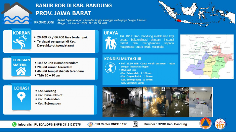
JAKARTA - Four sub-districts in Bandung Regency, West Java Province, were affected by flooding with water levels varying up to 100 cm. Thousands of houses were flooded and there were no reports of casualties as a result of the incident. One of the triggered floods was the high intensity rain on Sunday (10/11). The rainfall caused the Citarum River to overflow, which was monitored at 20.00 local time. The Regional Disaster Management Agency (BPBD) of Bandung Regency recorded 4 sub-districts affected in its area, including Soreang, Dayeuhkolot, Baleendah and Bojongsoang Districts. Of the four sub-districts, 8 administrative areas at the village or sub-district level were affected by the flood. The following are the names of the villages affected by the flood, Cincing Village (Soreang District), Dayeuhkolot Village and Pasawahan Village (Dayeuhkolot), Baleendah and Andir Villages (Baleendah), Bojongsoang Village, Bojongsari and Tegaluar (Bojongsoang). BPBD data for Bandung Regency as of Monday (11/1), at 06.00 WIB, as many as 20,409 families or 66,400 people were affected by this flood. In addition, BPBD monitors the presence of evacuation in Dayeuhkolot District. The number of residents who fled is still being collected by officers. The following is a provisional breakdown of the number of affected residents in three sub-districts, including Dayeuhkolot District 8,719 families / 26,078 people, Baleendah 9,208 families / 33,252 people and Bojongsoang 2,482 families / 7,070 people. Meanwhile, in Soreang District, officers are still collecting data. As for material losses, the temporary total in the three sub-districts is 10,572 houses submerged, 28 schools and 46 places of worship. Meanwhile, the latest information on Sunday (10/1), around 23.30 WIB, the weather was observed to be cloudy and rainy with light intensity. Water level (TMA) still occurs with information on TMA in Baleendah District 100 cm, Dayeuhkolot 90 cm, Bojongsoang 70 cm, while Soreang has receded. Bandung Regency is an area with frequent floods. Judging from InaRISK, this area is one of the areas with moderate to high flood potential. A total of 29 sub-districts with this potential danger, including the four sub-districts that experienced flooding. The public is urged to remain vigilant and alert, especially in the middle of the peak of the rainy season which will still occur until February 2021. The public can use the BMKG Info application to find out the rainfall forecasts up to the sub-district level. People who live on slopes, especially on slopes of more than 30 degrees to be more vigilant, especially if there is rain in the upstream area.
Impact Statistic
0
Dead
0
Missing
0
Injured
66.4K
Affected Person
0
Displaced
Human SADDD
- Dead -
- Missing -
- Injured -
- Affected Person 66,400
- Affected Family 20,409
- Internaly Displaced People -
- Refugees -
- Evacuation Center (in Country) -
- Evacuation Center (out Of Country) -
House
- Affected Houses 10,572
- Damage Partial -
- Totally Damage -
Infrastructure
- Bridges -
- Number of Roads -
- Road Distance (km) -
Public
- Schools 28
- Health -
- Government Office / Public Facilities -
- Settlements -
- Worship Places 46
- Others -
General
Cost
- Local Currency 0.00
- Cost of Damages -
- Cost of Damages (USD) -
- Cost of Assistance -
- Cost of Assistance (USD) -
Agricultural
- Rice Field -
- Other Crops -
- Fish Ponds -
- Cattle -
- Poultries -
- Livestock -
Relevant Disasters
The ASEAN Disaster Information Network (ADINet) is a repository of information concerning hazards and disasters that have happened in the region. The platform is open for public, which means that the public can submit information about any hazard and disaster to the AHA Centre. Thereafter, the AHA Centre will verify and validate any submitted information to ensure the accuracy of the data inputs. The AHA Centre can also add new information when relevant and as necessary. ADINet has been recording disaster information in the region since the AHA Centre was operational in 2012.

Supported by :