Indonesia, Flooding in Asahan Regency, North Sumatra
Aug 16, 2021 10:00
Sep 27, 2026 15:18
Location
Coordinate:
2.8023687744568, 99.56256259779
Administrative:
Sumatera Utara, Indonesia
Affected Area:
Sumatera Utara
Hazard
Main : Flood- Inundated Area (km) = fill value here
- Maximum Flood Depth (cm) = fill value here
Description
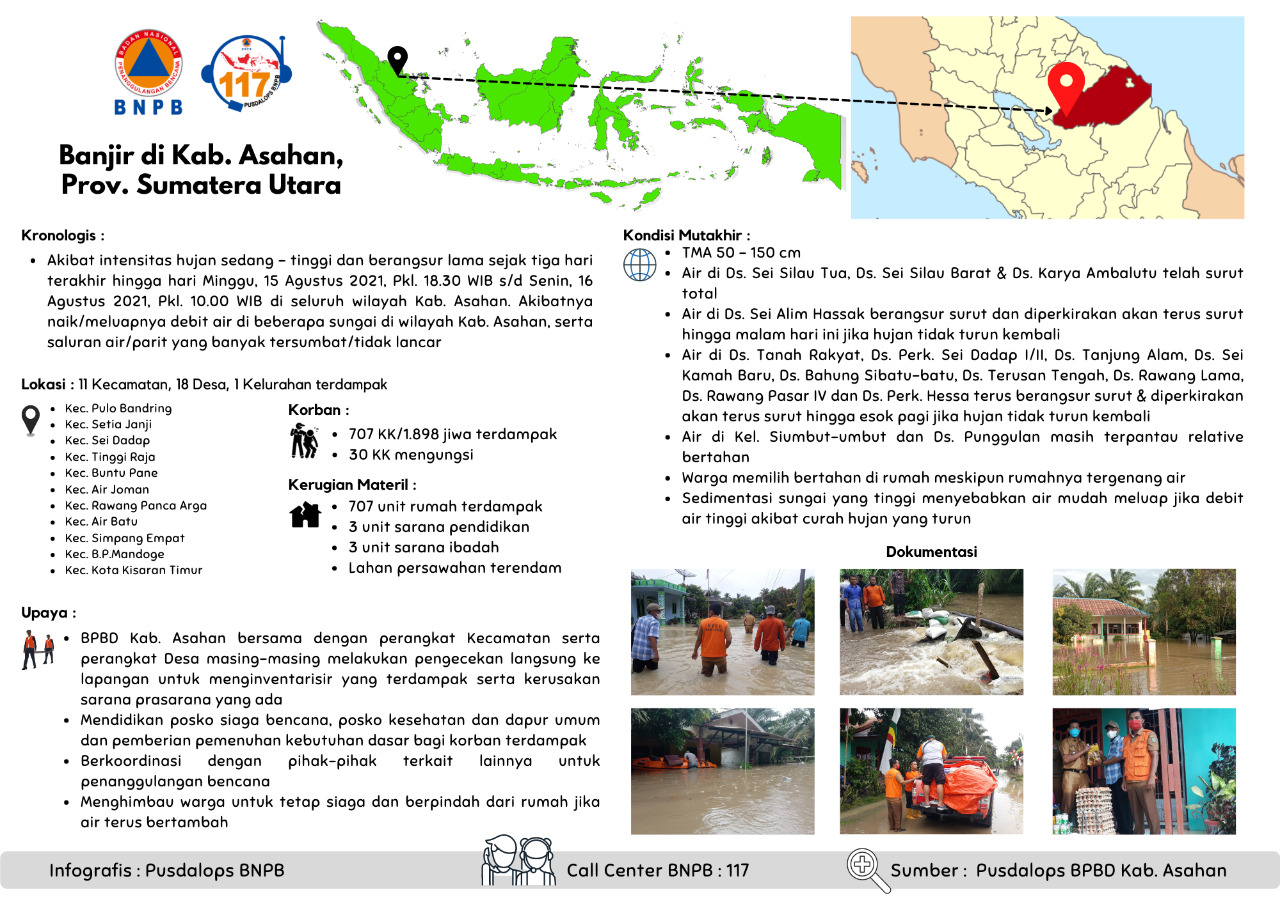
Floods in Kab. Asahan, Prov. North Sumatra
Chronology :
• Due to the moderate - high intensity of rain and gradually lasted for the last three days until Sunday, August 15, 2021, Pkl. 18.30 WIB to Monday, August 16, 2021, Pkl. 10.00 WIB in all areas of the Regency. sharpen. As a result, the water discharge rises/overflows in several rivers in the Kab. Sharpening, as well as many clogged/not smooth drains/troughs
Location :
Kab. Asahan
• Kec. Pulo Bandring
• Kec. Setia Janji
• Kec. Sei Dadap
• Kec. Tinggi Raja
• Kec. Buntu Pane
• Kec. Air Joman
• Kec. Rawang Panca Arga
• Kec. Air Batu
• Kec. Simpang Empat
• Kec. B. P. Mandoge
• Kec. Kota Kisaran Timur
Fatalities :
• 707 families / 1,898 people affected
• 30 families evacuate
Material Losses:
• 707 housing units affected
• 3 units of educational facilities
• 3 units of worship facilities
• Submerged rice fields
Effort :
• BPBD Kab. Asahan together with the sub-district and village apparatuses carried out direct checks in the field to take an inventory of those affected and the damage to existing infrastructure.
• Educate disaster preparedness posts, health posts and public kitchens and provide basic needs for affected victims
• Coordinate with other related parties for disaster management
• Calling on residents to stay alert and move from their homes if the water continues to rise
Up-to-date Condition:
• Flood depth 50 - 150 cm
• Water in Ds. Sei Silau Tua, Ds. Sei Silau Barat & Ds. Ambalutu's work has completely receded
• Water in Ds. Sei Alim Hassak is gradually receding and is expected to continue to recede until tonight if the rain does not return
• Water in Ds. People's Land, Ds. Perks. Sei Dadap I/II, Ds. Tanjung Alam, Ds. Sei Kamah Baru, Ds. Bahung Sibatu-batu, Ds. Middle Canal, Ds. Rawang Lama, Ds. Rawang Pasar IV and Ds. Perks. Hessa continues to gradually recede & is expected to continue to recede until tomorrow morning if it doesn't rain again
• Water in Ds. Siumbut-umbut and Ds. The superior is still observed to be relatively stable
• Residents choose to stay at home even though their house is flooded
• High river sedimentation causes water to easily overflow if the water discharge is high due to heavy rainfall
Source :
BPBD Kab. Asahan
Informed By:
BNPB PUSDALOPS
Complaint Number / Call Center : 117 (Toll Free)
Instagram : pusdalops_bnpb
Twitter : @Bnpbpusdalops
Impact Statistic
0
Dead
0
Missing
0
Injured
16.6K
Affected Person
510
Displaced
External Video
News
Human SADDD
- Dead -
- Missing -
- Injured -
- Affected Person 16,615
- Affected Family 3,323
- Internaly Displaced People 510
- Refugees -
- Evacuation Center (in Country) -
- Evacuation Center (out Of Country) -
House
- Affected Houses 3,323
- Damage Partial -
- Totally Damage -
Infrastructure
- Bridges -
- Number of Roads -
- Road Distance (km) -
Public
- Schools 5
- Health 1
- Government Office / Public Facilities 3
- Settlements -
- Worship Places 4
- Others -
General
Cost
- Local Currency 0.00
- Cost of Damages -
- Cost of Damages (USD) -
- Cost of Assistance -
- Cost of Assistance (USD) -
Agricultural
- Rice Field 1.00
- Other Crops -
- Fish Ponds -
- Cattle -
- Poultries -
- Livestock -
Relevant Disasters
The ASEAN Disaster Information Network (ADINet) is a repository of information concerning hazards and disasters that have happened in the region. The platform is open for public, which means that the public can submit information about any hazard and disaster to the AHA Centre. Thereafter, the AHA Centre will verify and validate any submitted information to ensure the accuracy of the data inputs. The AHA Centre can also add new information when relevant and as necessary. ADINet has been recording disaster information in the region since the AHA Centre was operational in 2012.

Supported by :