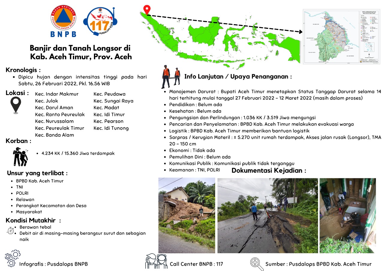
Indonesia, Flooding and Landslide in East Aceh Regency (Aceh)
Feb 26, 2022 16:56
Sep 27, 2026 15:20
Location
Coordinate:
4.6299783968692, 97.627732106662
Administrative:
Aceh, Indonesia
Affected Area:
Aceh
Hazard
Main : Flood- Inundated Area (km) = fill value here
- Maximum Flood Depth (cm) = fill value here
Description
Cause: Heavy rainfall
Location:
Lokasi :
Kec. Indar Makmur
• Gp. Julok Rayeuk Selatan
• Gp. Julok Rayeuk Utara
• Gp. Pelita Sagoup Jaya
• Gp. Seuneubok Cina
• Gp. Alue Ie Itam
• Gp. Alue Ie Mirah
• Gp. Jambo Lubok
• Gp. Blang Nisam
Kec. Julok
• Gp. Blang Jambe
• Gp. Teupin Raya
• Gp. Alue Cek Doi
• Gp. Blang Pauh 2
• Gp. Buket Siraja
• Gp. Labuan
• Gp. Julok Tunong
• Gp. Paya Bakong
• Gp. Blang Uyok
• Gp. Belang Gleum
Kec. Darul Aman
• Gp. Keude
• Gp. Alue Gadeng
• Gp. Bukit Raya
• Gp. Blang Buket
• Gp. Keumuneng Dua
• Gp. Bagok Panah Lhee
• Gp. Lhok Geulumpang
• Gp. Seuneubok Buloh
• Gp. Dama Pulo Sa
Kec. Ranto Peureulak
• Gp. Alue Udep
• Gp. Bhom Lama
• Gp. Punti Payong
• Gp. Mata Iee
• Gp. Alue Dua
• Gp. Paya Palas
• Gp. Alue Batee
• Gp. Seumali
• Gp. Pertamina
• Gp. Seumanah Jaya
Kec. Nurussalam
• Gp. Alue Siwah Serdang
Kec. Peureulak Timur
• Gp. Taulang Pateng
• Gp. Babah Krueng
• Gp. Snb Lapang
• Gp. Alue Tho
• Gp. Alue Gureb
• Gp. Snb Punti
• Gp. Snb Teungoh
Kec. Banda Alam
• Gp. Paton Rayeuk T
Kec. Peudawa
• Gp. Meunasah Krueng
• Gp. Asan Rampak
• Gp. Sama Dua
Kec. Sungai Raya
• Gp. Paya Ketapang
• Gp. Bukit Drien
Kec. Madat
• Gp. Lueng Sa
• Gp. Blang Awe
• Gp. Matang Kupala
• Gp. Seneubok Pidie
• Gp. Matang Kupula 2
Kec. Idi Timur
• Gp. Ule Glee
Kec. Pearson
• Gp. Bukit Tiga
Kec. Idi Tunong
• Gp. Buket Kreung
Effort :
• BPBD Kab. East Aceh coordinates with relevant agencies
• Conduct data collection
• Delegating the PB Task Force at the site
• Evacuating affected people
• BPBD of East Aceh Regency carry out on-site monitoring
• Establishing a Public Kitchen by the community
• Distribution of Assistance
Latest Condition:
• Heavy clouds
• The water discharge in each gradually recedes and some rises
Impact Statistic
0
Dead
0
Missing
0
Injured
15.4K
Affected Person
4.2K
Displaced
External Video
News
Human SADDD
- Dead -
- Missing -
- Injured -
- Affected Person 15,360
- Affected Family 4,234
- Internaly Displaced People 4,229
- Refugees -
- Evacuation Center (in Country) -
- Evacuation Center (out Of Country) -
House
- Affected Houses 5,270
- Damage Partial -
- Totally Damage -
Infrastructure
- Bridges -
- Number of Roads 1
- Road Distance (km) -
Public
- Schools -
- Health -
- Government Office / Public Facilities -
- Settlements -
- Worship Places -
- Others -
General
Cost
- Local Currency 0.00
- Cost of Damages -
- Cost of Damages (USD) -
- Cost of Assistance -
- Cost of Assistance (USD) -
Agricultural
- Rice Field -
- Other Crops -
- Fish Ponds -
- Cattle -
- Poultries -
- Livestock -
Relevant Disasters
The ASEAN Disaster Information Network (ADINet) is a repository of information concerning hazards and disasters that have happened in the region. The platform is open for public, which means that the public can submit information about any hazard and disaster to the AHA Centre. Thereafter, the AHA Centre will verify and validate any submitted information to ensure the accuracy of the data inputs. The AHA Centre can also add new information when relevant and as necessary. ADINet has been recording disaster information in the region since the AHA Centre was operational in 2012.

Supported by :