Indonesia, Flood in Pekalongan
Feb 18, 2018 04:24
Sep 27, 2026 15:11
Location
Coordinate:
-6.941083, 109.697084
Administrative:
Jawa Tengah, Indonesia
Affected Area:
Jawa Tengah
Hazard
Main : Flood- Inundated Area (km) = fill value here
- Maximum Flood Depth (cm) = fill value here
Description
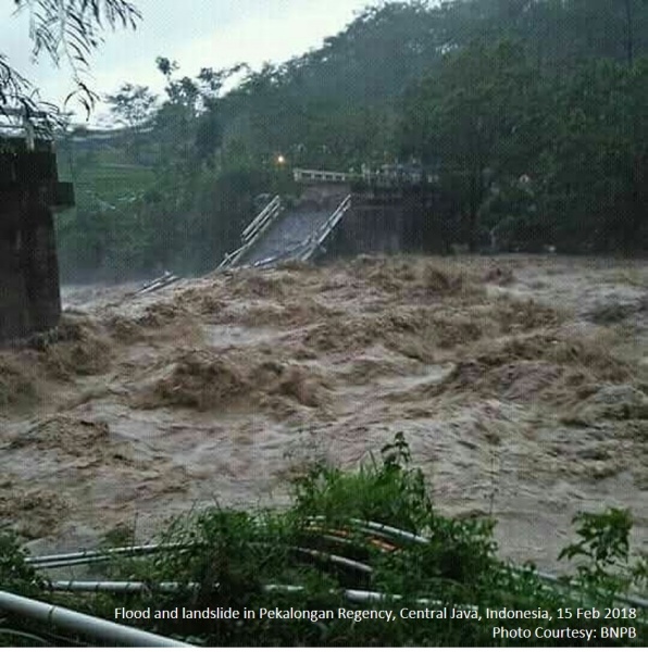
Heavy rain that took place on Thursday (15/2/2018) from afternoon to night caused floods hit some areas in Pekalongan Regency, Central Java Province. Until evening BPBD officers with TNI, Polri, Basarnas, SKPD, PMI, Tagana, volunteers and the community assisted the flood affected communities. Temporary data collected by BPBD Kabupaten Pekalongan reported that 2 bridges and thousands of houses affected by flood. There were no fatalities from the flood. Some of the damage caused by the flood is the Kalikeruh bridge connecting Luragung Village Kandangserang District Pekalongan Regency with Village Medayu Watukumpul Subdistrict Pemalang Regency drop out. Kali Asahan Bridge in Bubak Village Kandangserang Sub-district Pekalongan Regency also broke up. Bridge with a length of 8 meters and a width of 4 meters hit by landslides and a total break. In addition, Kandangserang Road in Kendangserang Village Kandangserang Sub-district landslides along 16 meters, 3 meters wide and 2 meters deep. Cars and motorcycles can still pass through but one lane. Landslide struck Karanganyar Lebakbarang Highway in Bantarkulon Village, Lebakbarang District. Traffic stalls completely because the landslide material closes the road. Floods hit several areas such as in Lambanggelun Village, Paninggaran Subdistrict. On Saturday early morning has subsided. Flood in the Village of Pacar Tirto District runoff Sengkarang River water high 30-40 cm. Floods hit 10 villages in Tirto district, Wonokerto subdistrict and Siwalan sub district 30-50 cm water level. BPBD, Indonesian Armed Forces, Police, Public Works agency, transportation agency and other local government agencies, volunteers and the community do the work for the handling of floods and landslides.
Impact Statistic
0
Dead
0
Missing
0
Injured
5K
Affected Person
0
Displaced
Human SADDD
- Dead -
- Missing -
- Injured -
- Affected Person 5,000
- Affected Family 1,000
- Internaly Displaced People -
- Refugees 0
- Evacuation Center (in Country) -
- Evacuation Center (out Of Country) 0
House
- Affected Houses 1,000
- Damage Partial 0
- Totally Damage 1,000
Infrastructure
- Bridges 2
- Number of Roads 1
- Road Distance (km) 0.00
Public
- Schools -
- Health -
- Government Office / Public Facilities 0
- Settlements 0
- Worship Places 0
- Others 0
General
Cost
- Local Currency 0.00
- Cost of Damages 0.00
- Cost of Damages (USD) -
- Cost of Assistance 0.00
- Cost of Assistance (USD) -
Agricultural
- Rice Field 0.00
- Other Crops 0.00
- Fish Ponds 0
- Cattle 0
- Poultries 0
- Livestock 0
Relevant Disasters
The ASEAN Disaster Information Network (ADINet) is a repository of information concerning hazards and disasters that have happened in the region. The platform is open for public, which means that the public can submit information about any hazard and disaster to the AHA Centre. Thereafter, the AHA Centre will verify and validate any submitted information to ensure the accuracy of the data inputs. The AHA Centre can also add new information when relevant and as necessary. ADINet has been recording disaster information in the region since the AHA Centre was operational in 2012.

Supported by :